
-
Federal
WorldView-1 Level 1B Panchromatic Satellite Imagery
National Aeronautics and Space Administration —
The WorldView-1 Level 1B Panchromatic Imagery collection contains satellite imagery acquired from Maxar Technologies (formerly known as DigitalGlobe) by the... -
Federal
MODIS/Terra Near Real Time (NRT) Land Surface Temperature/Emissivity 5-Min L2 Swath 1km
National Aeronautics and Space Administration —
The MODIS/Terra Near Real Time (NRT) level-2 Land Surface Temperature and Emissivity (LST/E) data (Shortname: MOD11_L2) incorporate 1 km pixels, which are produced... -
Federal
MODIS/Aqua Near Real Time (NRT) Temperature and Water Vapor Profiles 5-Min L2 Swath 5km
National Aeronautics and Space Administration —
The level-2 MODIS Temperature and Water Vapor Profile Product MYD07_L2 consists of 30 gridded parameters related to atmospheric stability, atmospheric temperature and... -
Federal
CERES and GEO-Enhanced TOA, Within-Atmosphere and Surface Fluxes, Clouds and Aerosols Daily Terra Edition4A
National Aeronautics and Space Administration —
CER_SYN1deg-Day_Terra-MODIS_Edition4A is the Clouds and the Earth's Radiant Energy System (CERES) and geostationary (GEO)-Enhanced Top-of-Atmosphere (TOA) and Surface... -
Federal
ARCTAS DC-8 Aircraft In-situ Aerosol Data
National Aeronautics and Space Administration —
ARCTAS_Aerosol_AircraftInSitu_DC8_Data is the in-situ aerosol data for the DC-8 aircraft collected during the Arctic Research of the Composition of the Troposphere... -
Federal
A Global Database of Gas Fluxes from Soils after Rewetting or Thawing, Version 1.0
National Aeronautics and Space Administration —
This database contains information compiled from published studies on gas flux from soil following rewetting or thawing. The resulting database includes 222 field and... -
Federal
G-LiHT Metrics V001
National Aeronautics and Space Administration —
Goddard’s LiDAR, Hyperspectral, and Thermal Imager (G-LiHT) mission is a portable, airborne imaging system that aims to... -
Federal
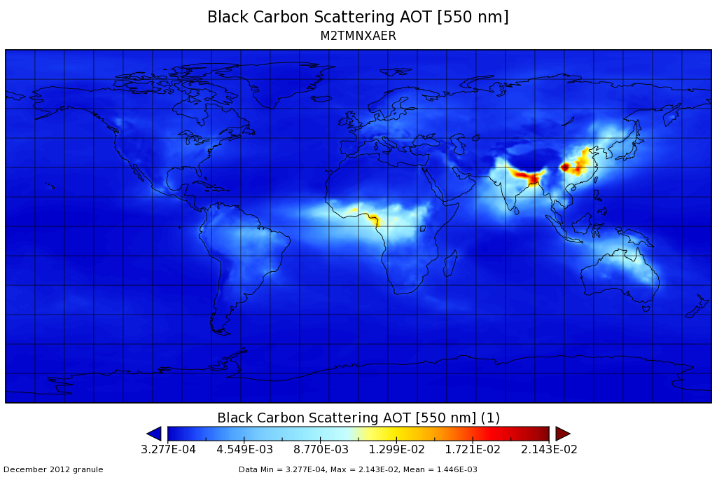
MERRA-2 tavgM_2d_aer_Nx: 2d,Monthly mean,Time-averaged,Single-Level,Assimilation,Aerosol Diagnostics 0.625 x 0.5 degree V5.12.4 (M2TMNXAER) at GES DISC
National Aeronautics and Space Administration —
M2TMNXAER (or tavgM_2d_aer_Nx) is a time-averaged 2-dimensional monthly mean data collection in Modern-Era Retrospective analysis for Research and Applications... -
Federal
VIIRS/NPP Land Surface Temperature/Emissivity Daily L3 Global 1km SIN Grid Night V001
National Aeronautics and Space Administration —
The VNP21A1N VIIRS Version 1 data product was decommissioned on April 8th, 2025. Users are encouraged to use Version 2 data products, which provideFederalGlobal Navigation Satellite System (GNSS) IGS Final Cumulative Combined Set of Station Coordinates Product from NASA CDDIS
National Aeronautics and Space Administration —
This derived product set consists of Global Navigation Satellite System Final Cumulative Station Positions/Velocities (no covariance matrix) Product available from...FederalCYGNSS Level 1 Science Data Record Version 3.2
National Aeronautics and Space Administration —
This CYGNSS Level 1 (L1) science data record dataset contains the version 3.2 geo-located Delay Doppler Maps (DDMs) calibrated into Power Received (Watts) and...FederalMODIS/Terra+Aqua Direct Broadcast Burned Area Monthly L3 Global 500m SIN Grid V006
National Aeronautics and Space Administration —
The MCD64A1 Version 6 data product was decommissioned on July 31, 2023. Users are encouraged to use the MCD64A1...FederalARCSIX P-3B Aircraft Multi-function Airborne Raman Lidar (MARLi) Data
National Aeronautics and Space Administration —
ARCSIX_AircraftRemoteSensing_P3B_MARLi_Data contains data collected by the Multi-function Airborne Raman Lidar (MARLi) onboard the P-3B aircraft during the Arctic...FederalLiDAR Derived Biomass, Canopy Height, and Cover for New England Region, USA, 2015
National Aeronautics and Space Administration —
This dataset provides 30 m gridded estimates of aboveground biomass density (AGBD), forest canopy height, and tree canopy coverage for the New England Region of the...FederalGEOS-5 FP-IT 3D Time-Averaged Model-Layer Assimilated Data Geo-Colocated to OMI/Aura UV2 1-Orbit L2 Swath 13x24km V4 (OMUFPMET) at GES DISC
National Aeronautics and Space Administration —
The GEOS-5 FP-IT 3D Time-Averaged Model-Layer Assimilated Data Geo-Colocated to OMI/Aura UV2 1-Orbit L2 Swath 13x24km (OMUFPMET) product provides selected...FederalSoil Temperature Station Data from Permafrost Regions of Russia (Selection of Five Stations), 1915 - 2000, Version 1
National Aeronautics and Space Administration —
This data set includes soil temperature data from boreholes located at five stations in Russia: Yakutsk, Verkhoyansk, Pokrovsk, Isit', and Churapcha. The data have...FederalGRACE-FO Level-1A Release version 4.0 from JPL in ASCII
National Aeronautics and Space Administration —
FOR EXPERT USE ONLY. The GRACE-FO Level-1A data contains telemetry data that has been converted to engineering units, from which Level-1B data products are derived....FederalGOES-R PLT Cloud Physics LiDAR (CPL)
National Aeronautics and Space Administration —
The GOES-R PLT Cloud Physics Lidar (CPL) dataset consists of backscatter coefficient, lidar depolarization ratio, layer top/base height, layer type, particulate...FederalMISR Level 1B2 Ellipsoid Data V003
National Aeronautics and Space Administration —
Multi-angle Imaging SpectroRadiometer (MISR) is an instrument designed to view Earth with cameras pointed in 9 different directions. As the instrument flies overhead,...FederalGlobal MODIS and FLUXNET-derived Daily Gross Primary Production, V2
National Aeronautics and Space Administration —
This dataset provides global gridded daily estimates of gross primary production (GPP) and uncertainties at 0.05-degree resolution for the period 2000-03-01 to the...9,607 datasets found

Official websites use .gov
A
.gov website belongs to an official government
organization in the United States.
Secure .gov websites use HTTPS
A
lock (
) or https:// means you’ve safely connected to
the .gov website. Share sensitive information only on official,
secure websites.