
-
Federal
ECOSTRESS Swath Land Surface Temperature and Emissivity Instantaneous L2 Global 70 m V002
National Aeronautics and Space Administration —
The ECOsystem Spaceborne Thermal Radiometer Experiment on Space Station (ECOSTRESS) mission measures the temperature of plants to better understand how much water... -
Federal
ECOSTRESS Gridded Surface Energy Balance Instantaneous L3 Global 70 m V002
National Aeronautics and Space Administration —
The ECOsystem Spaceborne Thermal Radiometer Experiment on Space Station (ECOSTRESS) mission measures the temperature of plants to better understand how much water... -
Federal
ECOSTRESS Swath Cloud Mask Instantaneous L2 Global 70 m V002
National Aeronautics and Space Administration —
The ECOsystem Spaceborne Thermal Radiometer Experiment on Space Station (ECOSTRESS) mission measures the temperature of plants to better understand how much water... -
Federal
Combined ASTER and MODIS Emissivity database over Land (CAMEL) Emissivity Monthly Global 0.05Deg V003
National Aeronautics and Space Administration —
The NASA Making Earth System Data Records for Use in Research Environments (MEaSUREs)... -
Federal
ECOSTRESS Tiled Evapotranspiration Instantaneous and Daytime L3 Global 70 m V002
National Aeronautics and Space Administration —
The ECOsystem Spaceborne Thermal Radiometer Experiment on Space Station (ECOSTRESS) mission measures the temperature of plants to better understand how much water... -
Federal
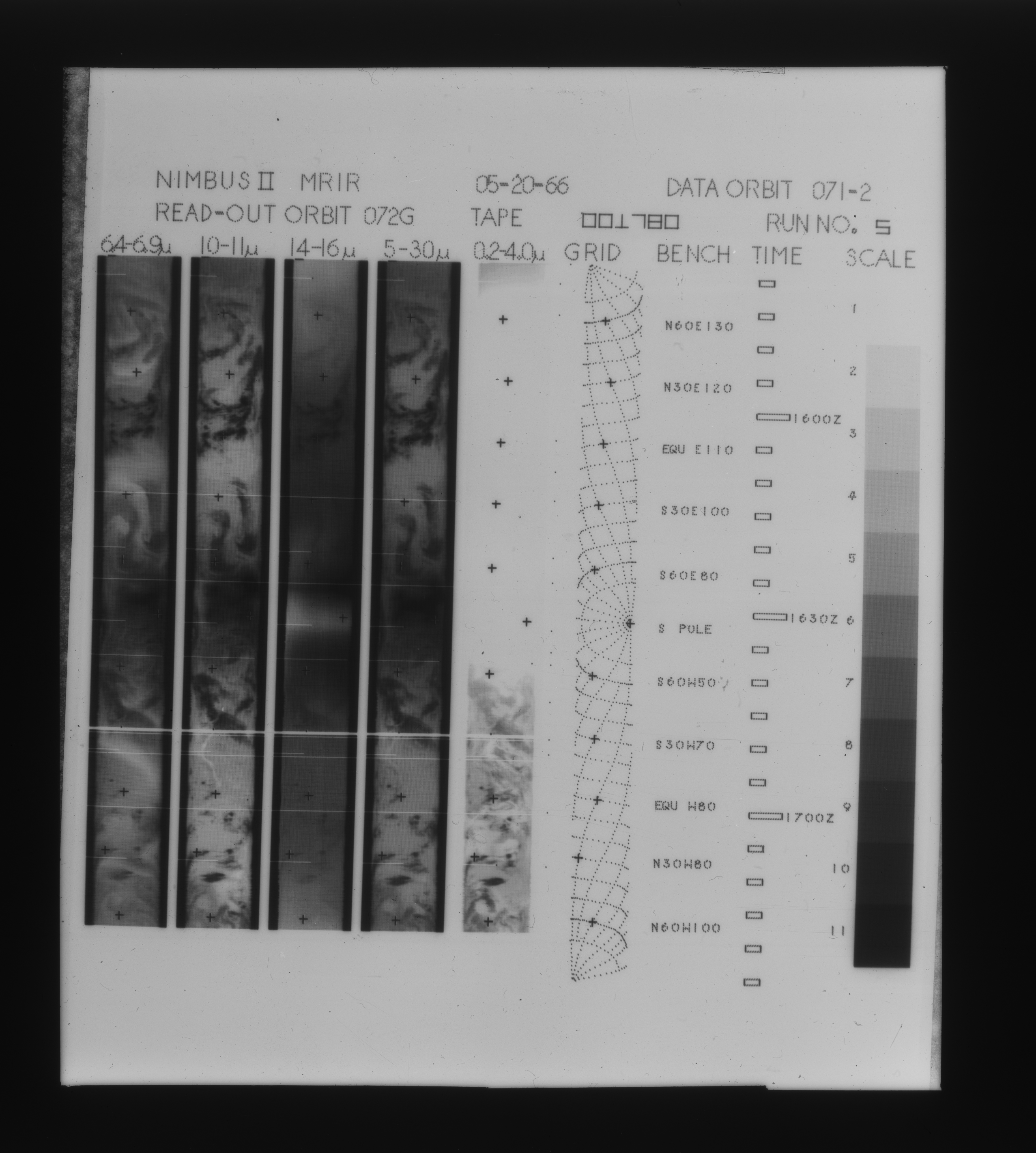
MRIR/Nimbus-2 Level 1 Meteorological Radiation Data V001 (MRIRN2L1) at GES DISC
National Aeronautics and Space Administration —
The Nimbus 2 Medium Resolution Infrared Radiometer (MRIR) was designed to measure electromagnetic radiation emitted and reflected from the earth and its atmosphere at... -
Federal
BUV/Nimbus-4 Level 2 Compressed Ozone Profile Data V005 (BUVN4L2CPOZ) at GES DISC
National Aeronautics and Space Administration —
The Nimbus-4 BUV Level 2 Compressed Ozone Profile Data collection or CPOZ contains total ozone, reflectivities, ozone mixing ratios and layer ozone amounts measured... -
Federal
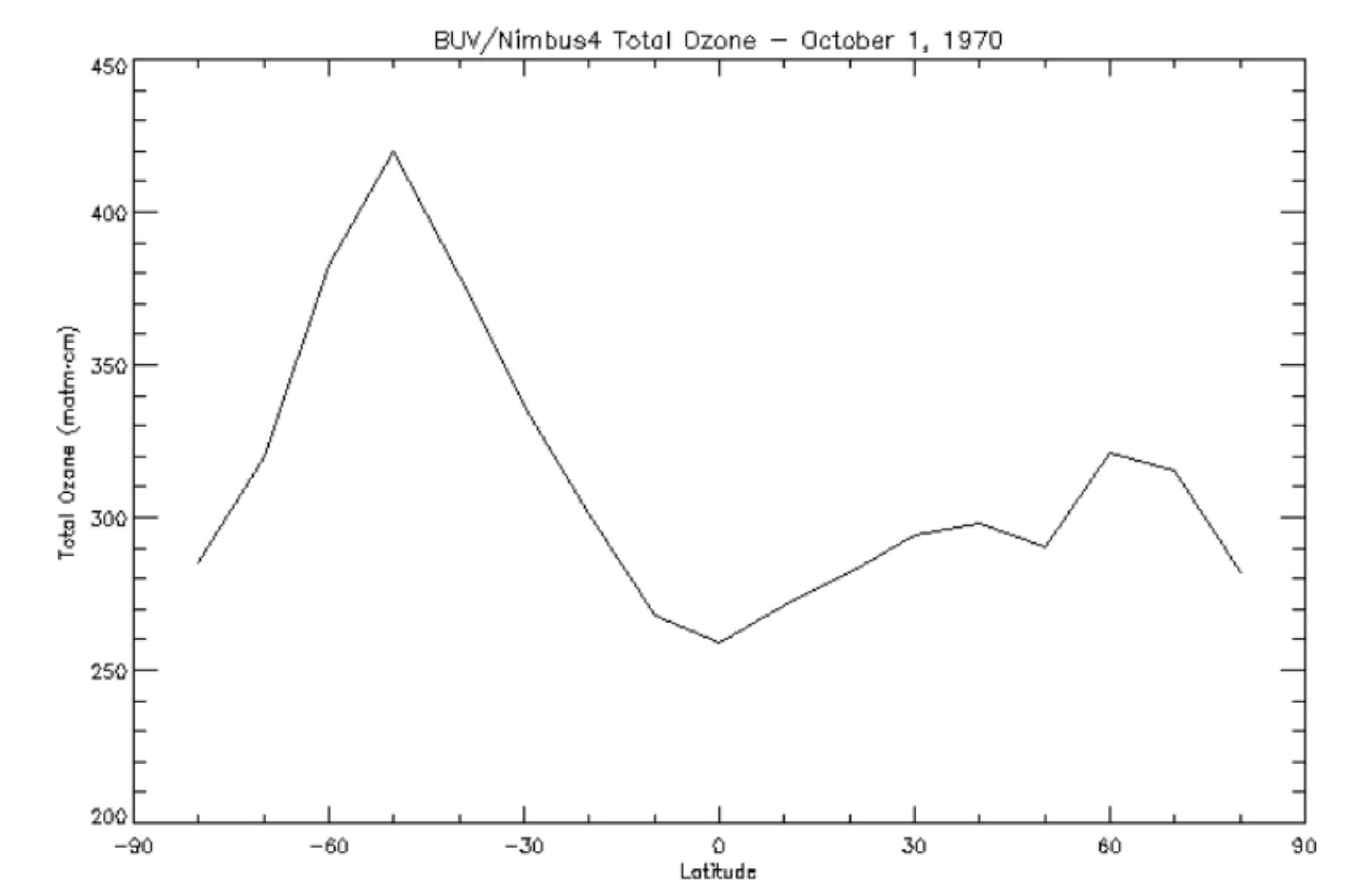
BUV/Nimbus-4 Level 3 Ozone Zonal Means V005 (BUVN4L3ZMT) at GES DISC
National Aeronautics and Space Administration —
The Nimbus-4 BUV Level 3 Ozone Zonal Means collection or ZMT contains total ozone, reflectivities, and ozone mixing ratios averaged in 10 degree latitude zones... -
Federal
BUV/Nimbus-4 Dark Current Study Working Data V001 (BUVN4L1DCW) at GES DISC
National Aeronautics and Space Administration —
The Nimbus-4 BUV Level-1 Dark Current Study Working Data is derived from the BUV Level 1 Radiance (RUT) product and contains the geophysical indices and... -
Federal
CAMEX-4 MOBILE X-BAND POLARIMETRIC WEATHER RADAR V1
National Aeronautics and Space Administration —
The CAMEX-4 Mobile X-Band Polarimetric Weather Radar dataset was collected by the Mobile X-band Polarimetric Weather Radar on Wheels (X-POW), which is a Doppler... -
Federal
BUV/Nimbus-4 Dark Current Study Master Data V001 (BUVN4L1DCM) at GES DISC
National Aeronautics and Space Administration —
The Nimbus-4 BUV Level-1 Dark Current Study Master Data is derived from the BUV Level 1 Radiance (RUT) product and contains the geophysical indices and... -
Federal
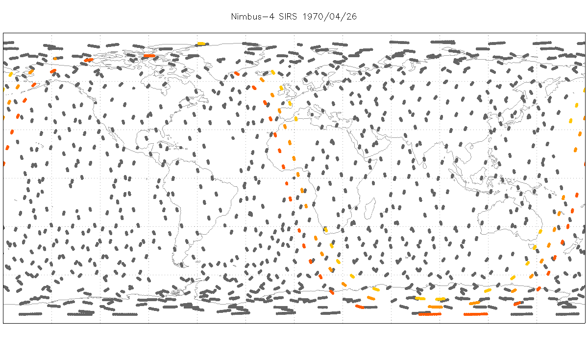
SIRS/Nimbus-4 Level 1 Radiance Data V001 (SIRSN4L1) at GES DISC
National Aeronautics and Space Administration —
SIRSN4L1 is the Nimbus-4 Satellite Infrared Spectrometer (SIRS) Level 1 Radiance Data product. SIRS measured infrared radiation (11 to 36 micrometers) emitted from... -
Federal
International Laser Ranging Service (ILRS) extension of the International Terrestrial Reference Frame 2020 (ITRF2020) TRF Model with additional SLR sites from NASA CDDIS
National Aeronautics and Space Administration —
Expanded set of SLR station positions and velocities in the ITRF2020 frame, includes historical sites NOT part of ITRF2020 and some very recently installed sites that... -
Federal
THIR/Nimbus-5 Level 1 Meteorological Radiation Data at 11.5 microns V001 (THIRN5L1CH115) at GES DISC
National Aeronautics and Space Administration —
THIRN5L1CH115 is the Nimbus-5 Temperature-Humidity Infrared Radiometer (THIR) Level 1 Meteorological Radiation Data at 11.5 microns product and contains radiances... -
Federal
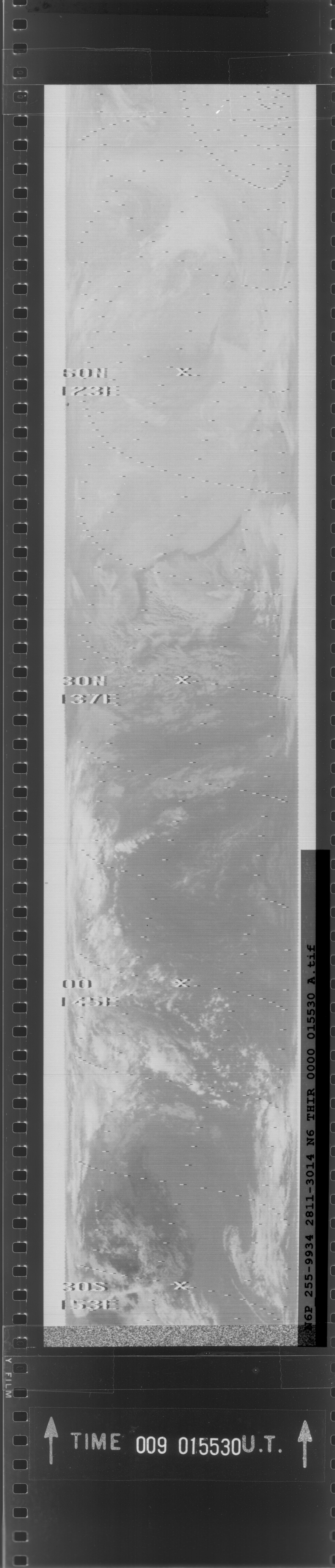
THIR/Nimbus-6 Images of Daytime and Nighttime Brightness Temperature on 70 mm Film V001 (THIRN6IM) at GES DISC
National Aeronautics and Space Administration —
The THIRN6IM data product consists of daily montages of brightness temperatures on 70 mm photofacsimile film strips from the Nimbus-6 Temperature-Humidity Infrared... -
Federal
THIR/Nimbus-4 Level 1 Meteorological Radiation Data at 11.5 microns V001 (THIRN4L1CH115) at GES DISC
National Aeronautics and Space Administration —
THIRN4L1CH115 is the Nimbus-4 Temperature-Humidity Infrared Radiometer (THIR) Level 1 Meteorological Radiation Data at 11.5 microns product and contains radiances... -
Federal
THIR/Nimbus-4 Images of Daytime and Nighttime Brightness Temperature at 6.7 microns on 70 mm Film V001 (THIRN4IMCH67) at GES DISC
National Aeronautics and Space Administration —
THIRN4IMCH67 is the Nimbus-4 Temperature-Humidity Infrared Radiometer (THIR) data product consisting of daily montages of brightness temperatures measured at 6.7... -
Federal
SAGE III Meteor-3M L2 Solar Event Species Profiles (Native) V004
National Aeronautics and Space Administration —
A Level 2 data file containing all the species products for a single solar event -
Federal
ESMR/Nimbus-5 Images of Brightness Temperature on 70 mm Film V001 (ESMRN5IM) at GES DISC
National Aeronautics and Space Administration —
ESMRN5IM is the Nimbus-5 Electrically Scanning Microwave Radiometer (ESMR) data product containing daily brightness temperature images from 70-mm photofacsimile film... -
Federal
LRIR/Nimbus-6 Level 2 Inverted Profiles of Temperature and Ozone V001 (LRIRN6L2IPAT) at GES DISC
National Aeronautics and Space Administration —
LRIRN6L2IPAT is the Nimbus-6 Limb Radiance Inversion Radiometer (LRIR) Level 2 Inverted Profiles of Temperature and Ozone data product. The product contains daily...

Official websites use .gov
A
.gov website belongs to an official government
organization in the United States.
Secure .gov websites use HTTPS
A
lock (
) or https:// means you’ve safely connected to
the .gov website. Share sensitive information only on official,
secure websites.