

644 datasets found
-
Federal
Geothermal Geodatabase for Rico Hot Springs Area and Lemon Hot Springs, Dolores and San Miguel Counties, Colorado
Department of Energy —
This geodatabase was built to cover several geothermal targets developed by Flint Geothermal in 2012 during a search for high-temperature systems that could be... -
Federal
Kilauea 2018 lower East Rift Zone eruption - fissure 22 lava flow
Department of the Interior —
The 2018 lower East Rift Zone eruption of Kilauea Volcano began in the late afternoon of 3 May, with fissure 1 opening and erupting lava onto Mohala Street in the... -
Federal
Okeanos Explorer (EX0903): Mapping Field Trial I Mendocino Ridge
National Oceanic and Atmospheric Administration, Department of Commerce —
The exhaustive study of the U.S. data holdings pertinent to the formulation of U.S. potential claims of an extended continental shelf under the United Nations... -
Federal
Geothermal Data Gap Analysis Over the Western US
Department of Energy —
NREL, as part of the Play Fairway Analysis Retrospective, compiled and mapped publicly available geologic and geophysical data in relation to the 2008 USGS geothermal... -
Federal
Kilauea 2018 lower East Rift Zone eruption - fissures 06 and 13 lava flow
Department of the Interior —
The 2018 lower East Rift Zone eruption of Kilauea Volcano began in the late afternoon of 3 May, with fissure 1 opening and erupting lava onto Mohala Street in the... -
County
KCSO Patrol Districts
King County, Washington —
Patrol districts for the King County Sheriff's Department -
Federal
The Everglades National Park and Big Cypress National Preserve Vegetation Mapping Project: Geodatabase–Southeast Saline Everglades (Region 2), Everglades National Park
Department of the Interior —
The Everglades National Park (EVER) and Big Cypress National Preserve (BICY) vegetation mapping project is part of the Comprehensive Everglades Restoration Plan... -
City
Miles Of Streets
City of San Francisco —
A report compiled for the Controller's Office containing miles of City streets broken out by jurisdiction. -
Federal
The Everglades National Park and Big Cypress National Preserve vegetation mapping project: Interim Report-Eastern Big Cypress (Regions 5 & 6), Big Cypress National Preserve (Geospatial Product & Final Report)
Department of the Interior —
The Everglades National Park and Big Cypress National Preserve vegetation mapping project is part of the Comprehensive Everglades Restoration Plan (CERP). It is a... -
Federal
Lacassine National Wildlife Refuge Land Status Map
Department of the Interior —
Land status map of Lacassine National Wildlife Refuge -
Federal
Areas with Surface Thermal Anomalies as Detected by ASTER and LANDSAT Data around South Canyon Hot Springs, Garfield County, Colorado
Department of Energy —
This map shows areas of anomalous surface temperature around South Canyon Hot Springs as identified from ASTER and LANDSAT thermal data and spatial based insolation... -
Federal
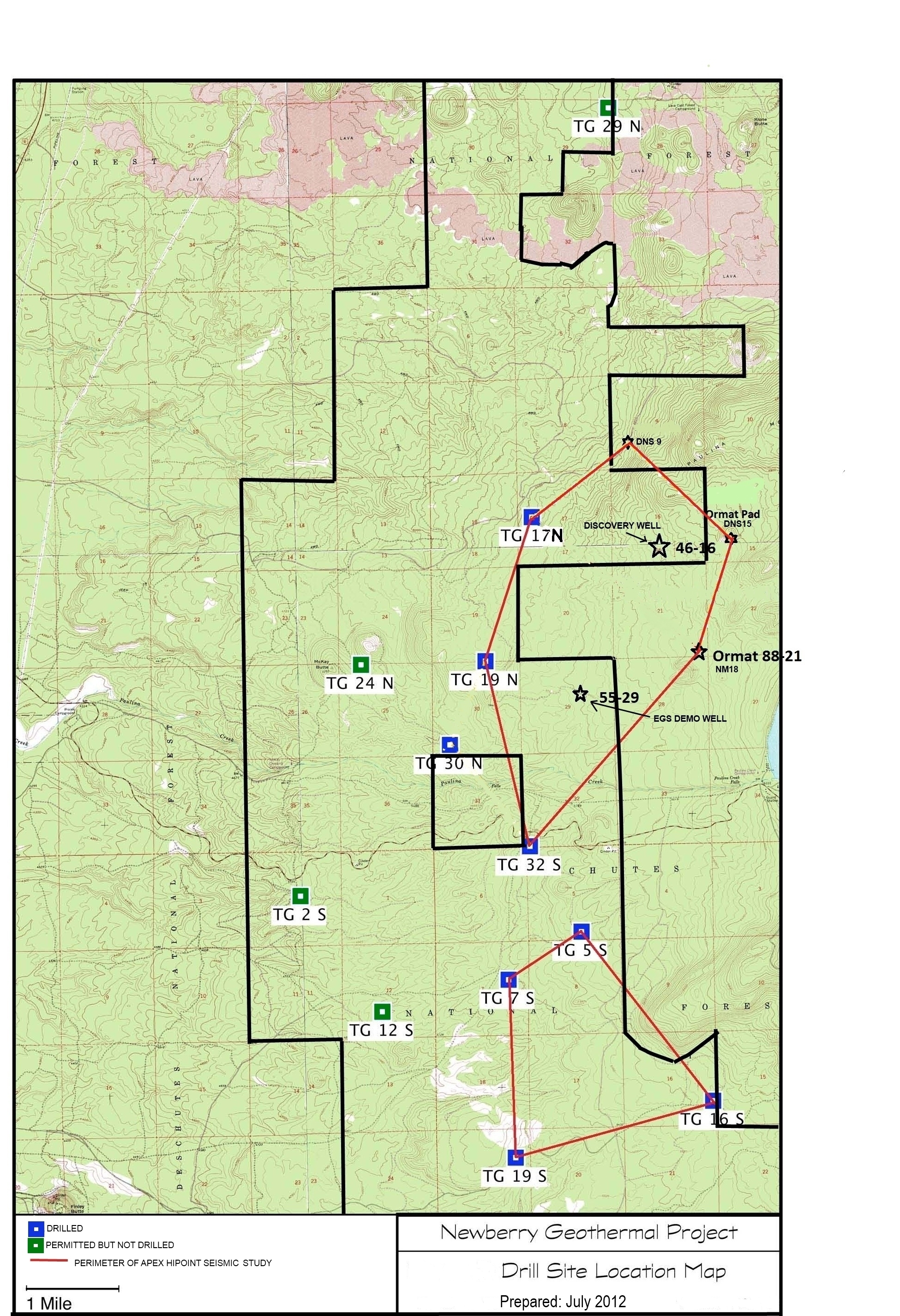
Map of Validation of Innovative Exploration Technologies for Newberry Volcano
Department of Energy —
A map showing location of wells permitted, drilled and seismic test, as part of validation of innovative exploration technologies done for the Newberry Volcano... -
Federal
2014 ITS World Congress Connected Vehicle Test Bed Demonstration Traveler Situation Data
Department of Transportation —
During the 2014 ITS World Congress a demonstration of the connected vehicle infrastructure in the City of Detroit was conducted. The test site included approximately... -
Federal
I-94 Automation FAQs
Department of Homeland Security —
In order to increase efficiency, reduce operating costs and streamline the admissions process, U.S. Customs and Border Protection has automated Form I-94 at air and...
644 datasets found