

654 datasets found
-
County
Loudoun River and Stream Corridor Resources (RSCR)
Loudoun County, Virginia —
River and Stream Corridor Resources (RSCR) is a part of the Natural and Environmental Resources chapter of the new Loudoun County Zoning Ordinance adopted on Dec 13,... -
Federal
Species detection and abundance using a biosensor - Development and Testing of in-situ Biological Sensors
National Oceanic and Atmospheric Administration, Department of Commerce —
The Environmental Sample Processor (ESP), http://www.mbari.org/ESP/, is an autonomous biological sensing system that conducts in situ collection and molecular... -
State
SSWP Cultural Resources
State of California —
The SSWP Cultural Resources Study is one of many relicensing documents for the South SWP (SSWP) Hydropower Project Number 2426. The California Department of Water... -
State
Shoreline change at Alaska coastal communities, Kipnuk, Alaska
State of Alaska —
The Division of Geological & Geophysical Surveys has analyzed long-term shoreline change at 48 Alaska communities. Shoreline datasets were compiled from... -
State
305b Assessed 2012 Estuary
State of Connecticut —
305b Assessed 2012 River, Lake, Estuary set: Connecticut 305b Assessed River 2012 is a 1:24,000-scale, line feature-based layer that includes rivers that have been... -
State
Single-beam bathymetric data near Chefornak, Alaska, collected August 17, 2022
State of Alaska —
Single-beam bathymetric data near Chefornak, Alaska, collected August 17, 2022, Raw Data File 2023-11, provides bathymetric data collected near Chefornak, Alaska, on... -
State
Landslide hazard susceptibility mapping in Haines, Alaska
State of Alaska —
Landslide hazard susceptibility mapping in Haines, Alaska, Report of Investigation 2024-8, provides a map and database of historical and prehistoric slope failures,... -
State
Sandy Beach Ecosystems, California South Coast MPA Baseline Study, 2011 to 2013
State of California —
Sandy beaches are among the most intensely used coastal ecosystems for human recreation and are vitally important to coastal economies. Beaches support unique... -
Federal
Yucatan 6km Sea Surface Currents
National Oceanic and Atmospheric Administration, Department of Commerce —
Radial Vectors quality controlled using hfradarpy Python toolbox -
State
Lidar-derived elevation data for Speel Arm, Southeast Alaska, collected September 7, 2019
State of Alaska —
The Alaska Division of Geological & Geophysical Surveys (DGGS) used aerial lidar to produce a classified point cloud, digital surface model (DSM), digital terrain... -
Federal
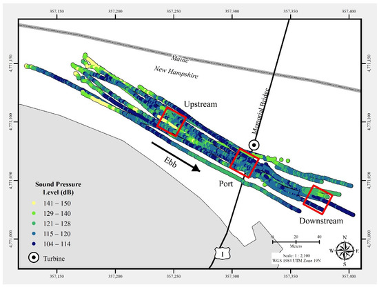
Triton Field Trials (TFiT) underwater noise - University of New Hampshire Living Bridge turbine Processed Data
Department of Energy —
In July 2021, a commercial-off-the-shelf hydrophone was deployed in a free-drifting configuration to measure underwater acoustic emissions and characterize a 25 kW-... -
Federal
RTOFS Forecast, 3D, Daily, Global, Latest Model Run, today - today+8days, Lon+/-180
National Oceanic and Atmospheric Administration, Department of Commerce —
The global operational Real-Time Ocean Forecast System (Global RTOFS) at the NOAA National Centers for Environmental Prediction is based on an eddy resolving 1/12°... -
State
Addendum A: Regional tsunami hazard assessment for Pasagshak, Alaska
State of Alaska —
Report of Investigation 2019-6A, Addendum A: Regional tsunami hazard assessment for Pasagshak, Alaska, provides an estimated extent of the tsunami hazard zone in the... -
Federal
Rutgers, Realtime Waves 13mhz SPRK
National Oceanic and Atmospheric Administration, Department of Commerce —
Mid-Atlantic Regional Association Coastal Ocean Observing System (MARACOOS) Wave Heights. Ocean Wave Heights. Center for Ocean Observing and Leadership, Department of... -
State
Aquifer Protection Area
State of Connecticut —
See full Data Guide here. Aquifer Protection Areas Set is a 1:24,000-scale, polygon feature-based layer that includes all Preliminary (Level B) and Final (Level A)... -
State
Photogrammetric digital surface models and orthoimagery for 26 coastal communities of western Alaska
State of Alaska —
The State of Alaska Division of Geological & Geophysical Surveys acquired photogrammetric digital surface models (DSMs) and co-registered orthorectified aerial... -
State
Shoreline change at Alaska coastal communities, Dillingham, Alaska
State of Alaska —
The Division of Geological & Geophysical Surveys has analyzed long-term shoreline change at 48 Alaska communities. Shoreline datasets were compiled from... -
State
Lidar-derived surface elevation data for Glen Alps, Southcentral Alaska, collected August 17, 2024
State of Alaska —
Lidar-derived surface elevation data for Glen Alps, Southcentral Alaska, collected August 17, 2024, Raw Data File 2025-19, releases classified point cloud, digital... -
State
Shoreline change at Alaska coastal communities, Stebbins, Alaska
State of Alaska —
The Division of Geological & Geophysical Surveys has analyzed long-term shoreline change at 48 Alaska communities. Shoreline datasets were compiled from...
654 datasets found