
-
Federal
GPM GMI (GPROF) Climate-based Radiometer Precipitation Profiling L2A 1.5 hours 4 km x 4 km V07 (GPM_2AGPROFGPMGMI_CLIM) at GES DISC
National Aeronautics and Space Administration —
Version 07 is the current version of the data set. Older versions will no longer be available and have been superseded by Version 07. The 'CLIM' products differ from... -
Federal
Data for Advanced Metrology Suite for Linking Residual Stress to FundamentalProperties of Thermoset Packaging Materials
National Institute of Standards and Technology —
This repository contains data generated to support and ECTC 2025 conference manuscript titled "Advanced Metrology Suite for Linking Residual Stress to Fundamental... -
Federal
Data from: Quantification and diagnostic relevance of blood and heme-mediated inhibition of prion detection by RT-QuIC
Department of Agriculture —
Purpose of the study:The mechanisms of inhibition mediated by heme on the prion protein misfolding reaction and detection of scrapie prions by the real-time quaking-... -
Federal
CERES and GEO-Enhanced TOA, Within-Atmosphere and Surface Fluxes, Clouds and Aerosols 1-Hourly Terra-Aqua-NOAA20 Edition4B
National Aeronautics and Space Administration —
CER_SYN1deg-1Hour_Terra-Aqua-NOAA20_Edition4B is the Clouds and the Earth's Radiant Energy System (CERES) and geostationary (GEO) Top-of-Atmosphere (TOA) Within-... -
Federal
Global Soil Texture and Derived Water-Holding Capacities (Webb et al.)
National Aeronautics and Space Administration —
A standardized global data set of soil horizon thicknesses and textures (particle size distributions) was compiled by Webb et al. This data set will be used for the... -
Federal
CMS: LiDAR-derived Biomass, Canopy Height and Cover, Sonoma County, California, 2013
National Aeronautics and Space Administration —
This data set provides estimates of above-ground biomass (AGB), canopy height, and percent tree cover at 30-m spatial resolution for Sonoma County, California, USA,... -
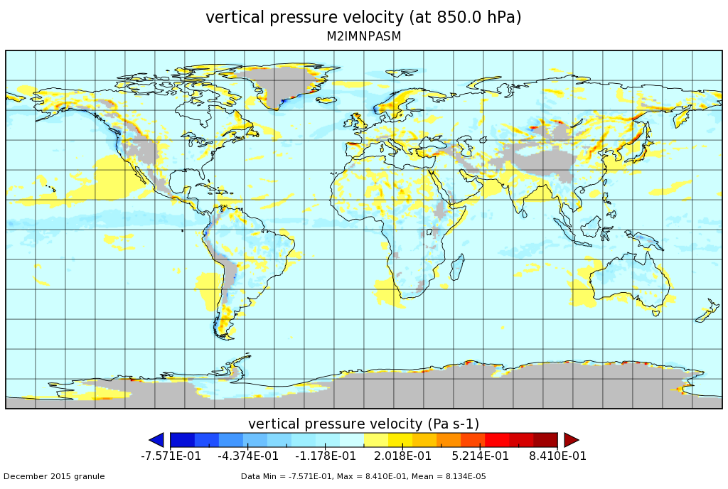
Federal
MERRA-2 instM_3d_asm_Np: 3d,Monthly mean,Instantaneous,Pressure-Level,Assimilation,Assimilated Meteorological Fields 0.625 x 0.5 degree V5.12.4 (M2IMNPASM) at GES DISC
National Aeronautics and Space Administration —
M2IMNPASM (or instM_3d_asm_Np) is an instantaneous 3-dimensional monthly mean data collection in Modern-Era Retrospective analysis for Research and Applications... -
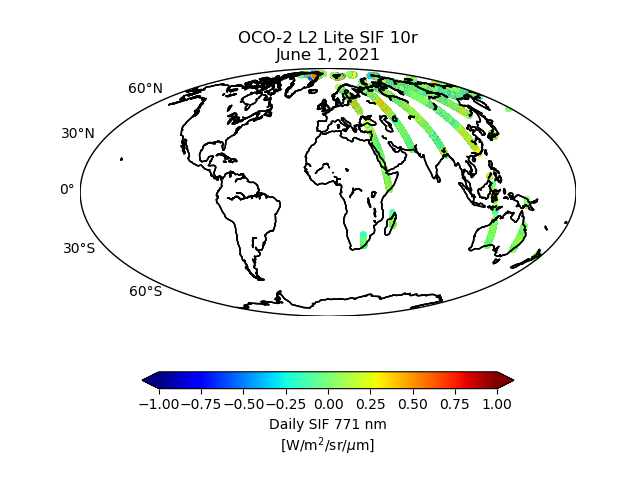
Federal
OCO-2 Level 2 bias-corrected solar-induced fluorescence and other select fields from the IMAP-DOAS algorithm aggregated as daily files, Retrospective processing V10r (OCO2_L2_Lite_SIF) at GES DISC
National Aeronautics and Space Administration —
Version 10r is the current version of the data set. Older versions will no longer be available and are superseded by Version 10r. The OCO-2 SIF Lite files contain... -
Federal
Voyager 2 Saturn Plasma Wave Spectrometer (PWS) Resampled Spectral Analyzer, Version 1.0, 48 s Data
National Aeronautics and Space Administration —
- Data Set Overview\n =================\n\n+-------------------------------------------------+\n| Data Characteristics | Value...
-
Federal
Delta-X: UAVSAR L1 Single Look Complex (SLC) Stack Products, MRD, Louisiana, 2021
National Aeronautics and Space Administration —
This dataset contains UAVSAR Level 1 (L1) Single Look Complex (SLC) stack products for Delta-X flight lines acquired during 2021-03-27 to 2021-04-18 (spring) and... -
Federal
TOVS LMD MONTHLY GRIDS from NOAA-12 V01 (TOVSBMND) at GES DISC
National Aeronautics and Space Administration —
Level 3 parameters from HIRS/2 and MSU radiances using the Improved Initialization Inversion (3I) classification retrieval scheme by the Laboratoire de Meteorologie... -
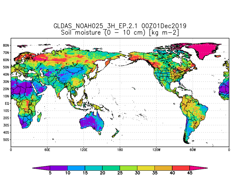
Federal
GLDAS Noah Land Surface Model L4 3 hourly 0.25 x 0.25 degree Early Product V2.1 (GLDAS_NOAH025_3H_EP) at GES DISC
National Aeronautics and Space Administration —
NASA Global Land Data Assimilation System Version 2 (GLDAS-2) has three components: GLDAS-2.0, GLDAS-2.1, and GLDAS-2.2. GLDAS-2.0 is forced entirely with the... -
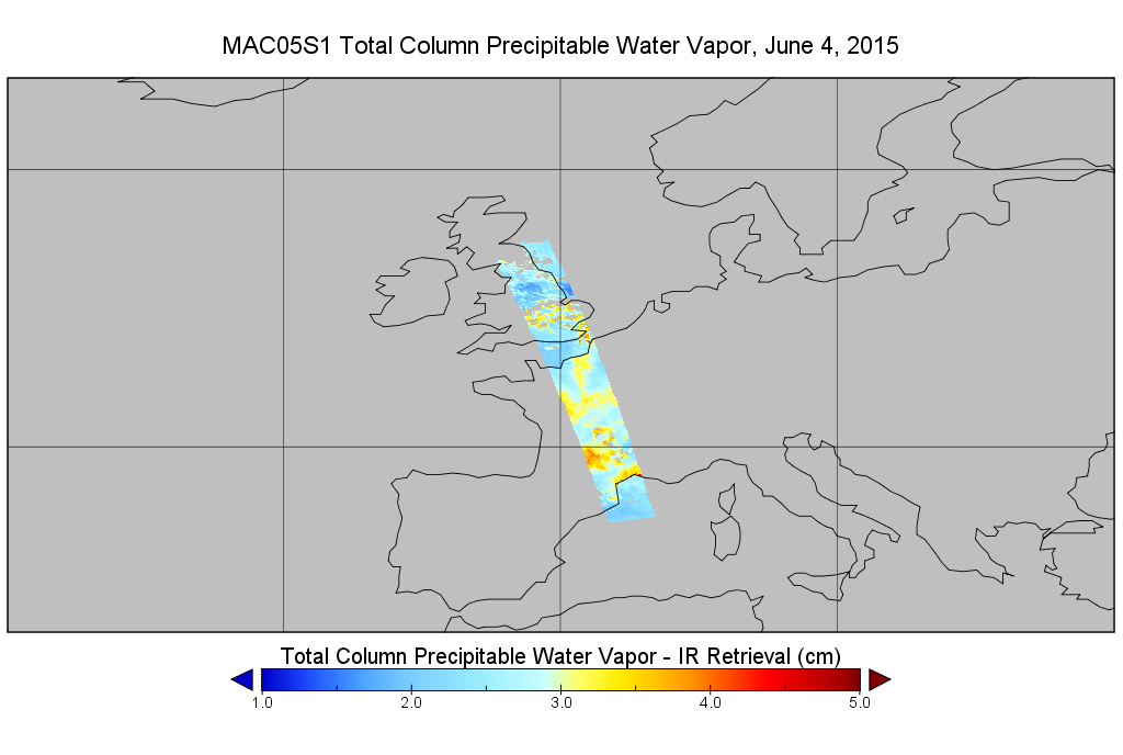
Federal
MODIS/Aqua Total Precip Water Vapor 1km and 5km 5-Min L2 Swath Subset along MLS V002 (MAM05S0) at GES DISC
National Aeronautics and Space Administration —
This is the MODIS/Aqua subset along MLS field of view track. The goal of the subset is to select and return MODIS data that are within +-100 km across the MLS track.... -
Federal
CALIPSO Lidar Level 3 Tropospheric Aerosol Profiles, Cloudy Sky Transparent Data, Standard V4-21
National Aeronautics and Space Administration —
CAL_LID_L3_Tropospheric_APro_CloudySkyTransparent-Standard-V4-21 is the Cloud-Aerosol Lidar and Infrared Pathfinder Satellite Observation (CALIPSO) Lidar Level 3... -
Federal
Sentinel-6 NASA/JPL GNSS-RO Near-Real-Time Level 1B V1 (S6A_RO_1B_NRT_NC__) at GES DISC
National Aeronautics and Space Administration —
This dataset provides the L1B Global Navigation Satellite System (GNSS) Radio-Occultation (RO) Near-Real-Time (NRT) retrieval generated by NASA's Jet Propulsion... -
Federal
Sounder SIPS: Suomi NPP CrIMSS Level 2 CHART Normal Spectral Resolution: Atmosphere, cloud and surface geophysical state V1
National Aeronautics and Space Administration —
The objective of this limited edition data collection is to examine products generated by the Climate Heritage AIRS Retrieval Technique (CHART) algorithm to analyze... -
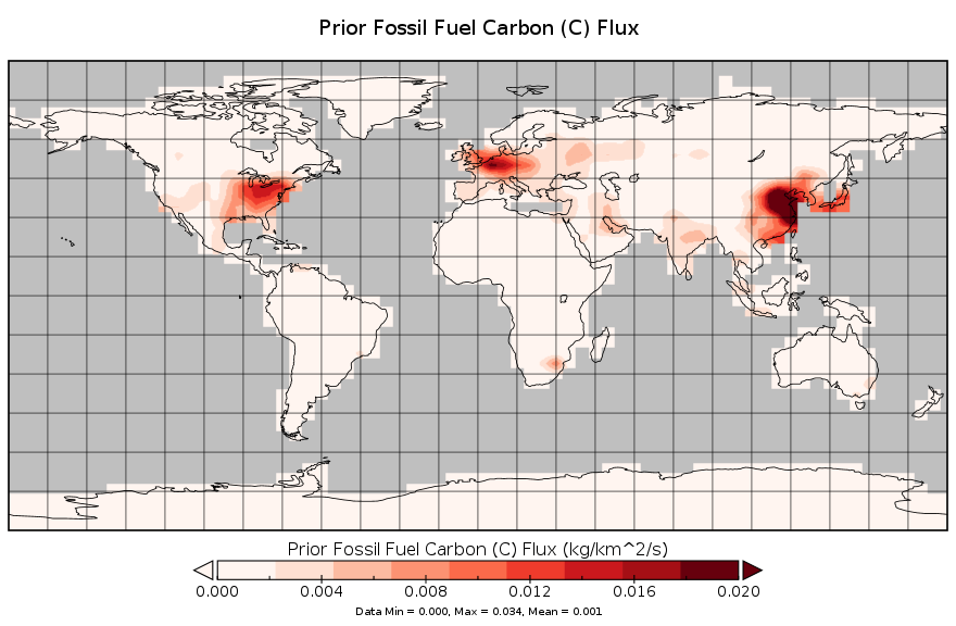
Federal
Carbon Monitoring System Carbon Flux for Fossil Fuel Prior L4 V2 (CMSFluxFossilFuelPrior) at GES DISC
National Aeronautics and Space Administration —
This dataset provides the Carbon Flux for Fossil Fuel Prior. The NASA Carbon Monitoring System (CMS) is designed to make significant contributions in characterizing,... -
Federal
Harmonic Constants for Baroclinic Tide Prediction
National Aeronautics and Space Administration —
This dataset of Harmonic Constants for Baroclinic Tide Prediction was produced by Edward Zaron (Oregon State University) and Shane Elipot (University of Miami). It... -
Federal
GPCP Precipitation Level 3 Monthly 0.5-Degree V3.2 (GPCPMON) at GES DISC
National Aeronautics and Space Administration —
Version 3.2 has been superseded by Version 3.3 (10.5067/MEASURES/GPCP/DATA306). The Global Precipitation Climatology Project (GPCP) is the precipitation component of... -
Federal
Snake River Plain FORGE: Site Characterization Data
Department of Energy —
The site characterization data used to develop the conceptual geologic model for the Snake River Plain site in Idaho, as part of phase 1 of the Frontier Observatory...

Official websites use .gov
A
.gov website belongs to an official government
organization in the United States.
Secure .gov websites use HTTPS
A
lock (
) or https:// means you’ve safely connected to
the .gov website. Share sensitive information only on official,
secure websites.