
-
Federal
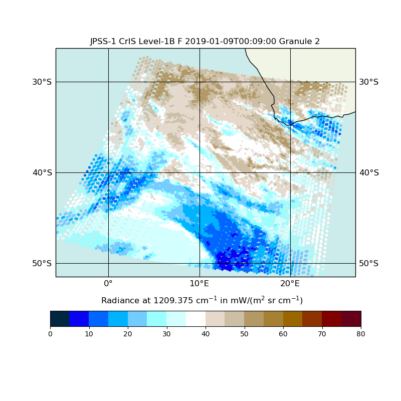
JPSS-1 CrIS Level 1B Full Spectral Resolution V2 (SNDRJ1CrISL1B) at GES DISC
National Aeronautics and Space Administration —
The Cross-track Infrared Sounder (CrIS) Level 1B Full Spectral Resolution (FSR) data files contain radiance measurements along with ancillary spacecraft, instrument,... -
Federal
Global Vegetation Height Metrics from GEDI and ICESat2
National Aeronautics and Space Administration —
This dataset provides global rasters of relative height metrics for vegetation from Global Ecosystem Dynamics Investigation (GEDI) L2A data and Ice, Cloud, and Land... -
Federal
VIIRS/NPP Active Fires 6-Min L2 Swath 375m - NRT
National Aeronautics and Space Administration —
The VNP14IMG_NRT is a Near Real Time (NRT) S-NPP/VIIRS 375 m active fire detection data product (Schroeder 2014). The product is built on the EOS/MODIS fire product... -
Federal
Land Resources of Russia -- Maps of Soil Characteristics, Version 1
National Aeronautics and Space Administration —
This data set consists of maps of various soil characteristics for all of Russia. The maps are available as ESRI Shapefiles and they are accompanied by databases of... -
Federal
IceBridge Sea Ice Freeboard, Snow Depth, and Thickness Quick Look, Version 1
National Aeronautics and Space Administration —
This data set is an evaluation product containing derived geophysical data products retrieved over the Arctic sea ice cover, using the IceBridge Airborne Topographic... -
Federal
GPM IMERG Final Precipitation L3 1 month 0.1 degree x 0.1 degree V07 (GPM_3IMERGM) at GES DISC
National Aeronautics and Space Administration —
Version 07B is the current version of the IMERG data sets. Older versions will no longer be available and have been superseded by Version 07. The Integrated Multi-... -
Federal
AHI/Himawari-08 Dark Target Aerosol 10-Min L2 Full Disk 10 km
National Aeronautics and Space Administration —
The AHI/Himawari-08 Dark Target Aerosol 10-Min L2 Full Disk 10 km product, short-name XAERDT_L2_AHI_H08 is provided at 10-km spatial resolution (at-nadir) and a... -
Federal
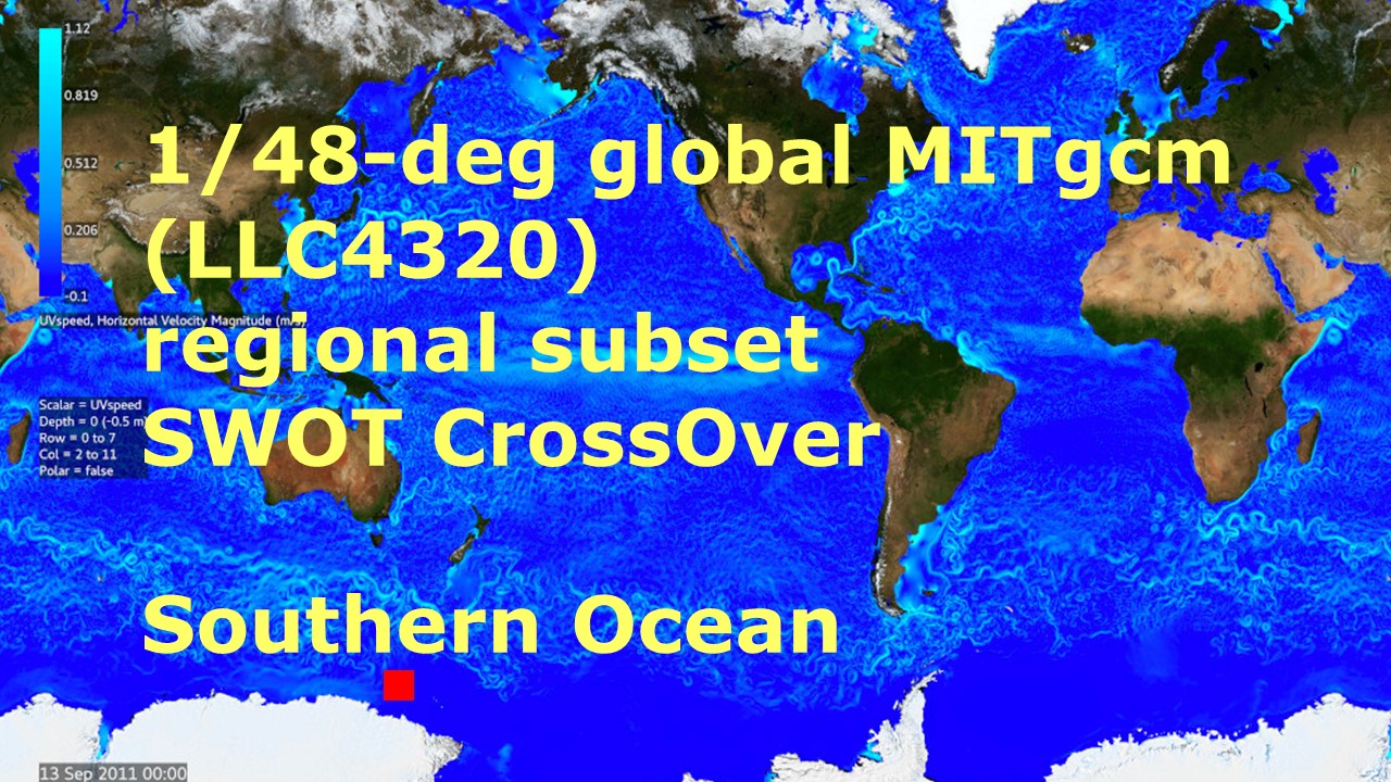
Southern Ocean Pre-SWOT Level-4 Hourly MITgcm LLC4320 Native Grid 2km Oceanographic Dataset Version 1.0
National Aeronautics and Space Administration —
This dataset provides a regional multivariate oceanographic state estimate from a global ocean numerical simulation with a focus on the Southern Ocean region. The... -
Federal
Global Navigation Satellite System (GNSS) IGS Summary of Orbit and Clock Comparisons of Analysis Center (AC) and Combination Real-Time Solutions with IGS Rapid Solutions from NASA CDDIS
National Aeronautics and Space Administration —
This derived product set consists of a summary comparing the International GNSS Service (IGS) Real-Time Service (RTS) orbit and clock products from all analysis... -
Federal
Submarine Upward Looking Sonar Ice Draft Profile Data and Statistics, Version 1
National Aeronautics and Space Administration —
This data set consists of upward looking sonar sea ice draft data collected by submarines in the Arctic Ocean. It includes data from both U.S. Navy and Royal Navy... -
Federal
MODIS/Terra Land Surface Temperature/Emissivity 8-Day L3 Global 1km SIN Grid V006
National Aeronautics and Space Administration —
The MOD11A2 Version 6 data product was decommissioned on July 31, 2023. Users are encouraged to use the MOD11A2... -
Federal
HAQAST Sentinel-5P TROPOMI Nitrogen Dioxide (NO2) GLOBAL Annual Level 3 0.1 x 0.1 Degree Gridded Data Version 2.4 (HAQ_TROPOMI_NO2_GLOBAL_A_L3) at GES DISC
National Aeronautics and Space Administration —
This product provides level 3 annual averages of tropospheric Nitrogen dioxide (NO2) vertical column density derived from the level 2 Tropospheric Monitoring... -
Federal
VIIRS/NPP Burned Area Monthly L4 Global 500m SIN Grid V002
National Aeronautics and Space Administration —
The daily NASA/NOAA Suomi National Polar-orbiting Partnership (Suomi NPP) Visible Infrared Imaging Radiometer Suite (VIIRS) Burned Area (VNP64A1) Version 2 data... -
Federal
First ISCCP Regional Experiment (FIRE) Atlantic Stratocumulus Transition Experiment (ASTEX) INMG Funchal Sounding Data
National Aeronautics and Space Administration —
The First ISCCP Regional Experiments have been designed to improve data products and cloud/radiation parameterizations used in general circulation models (GCMs).... -
Federal
NLDAS Noah Land Surface Model L4 Monthly 0.125 x 0.125 degree V2.0 (NLDAS_NOAH0125_M) at GES DISC
National Aeronautics and Space Administration —
This data set contains fifty-two fields simulated from the Noah land-surface model (LSM) for Phase 2 of the North American Land Data Assimilation System (NLDAS-2).... -
Federal
MODIS/Terra Leaf Area Index/FPAR 8-Day L4 Global 500m SIN Grid V061
National Aeronautics and Space Administration —
The MOD15A2H Version 6.1 Moderate Resolution Imaging Spectroradiometer (MODIS) combined Leaf Area Index (LAI) and Fraction of Photosynthetically Active Radiation... -
Federal
WorldView-2 Level 2A Multispectral 8-Band Satellite Imagery
National Aeronautics and Space Administration —
The WorldView-2 Level 2A Multispectral 8-Band Imagery collection contains satellite imagery acquired from Maxar Technologies (formerly known as DigitalGlobe) by the... -
Federal
Weather Research and Forecasting (WRF) Model IMPACTS
National Aeronautics and Space Administration —
The Weather Research and Forecasting (WRF) Model IMPACTS dataset includes model data simulated by the Weather Research and Forecasting (WRF) model for the... -
Federal
TES/Aura L3 Ozone Daily Gridded V006
National Aeronautics and Space Administration —
TL3O3D_6 is the Tropospheric Emission Spectrometer (TES)/Aura L3 Ozone Daily Gridded Version 6 data product. TES was an instrument aboard NASA's Aura satellite and...

Official websites use .gov
A
.gov website belongs to an official government
organization in the United States.
Secure .gov websites use HTTPS
A
lock (
) or https:// means you’ve safely connected to
the .gov website. Share sensitive information only on official,
secure websites.