
-
Federal
Video transects of coral reefs on the west coast of the island of Hawaii collected from 2017-02-03 to 2017-02-08 (NCEI Accession 0172858)
National Oceanic and Atmospheric Administration, Department of Commerce —
This data set contains video transects of coral reefs on the west coast of the island of Hawaii collected during February of 2017. The videos are in MP4 format and... -
Federal
CRED Optical Validation Data at the island of Ta'u in American Samoa, 2012 to support Benthic Habitat Mapping (TOAD)
National Oceanic and Atmospheric Administration, Department of Commerce —
Optical validation data were collected using the Tethered Optical Assessment Device (TOAD), a sled equipped with underwater video camera, still camera and lights.... -
Federal
Long-Term Monitoring at the East and West Flower Garden Banks National Marine Sanctuary in the Gulf of Mexico, 2007-2008 (NCEI Accession 0070125)
National Oceanic and Atmospheric Administration, Department of Commerce —
The Long-Term Monitoring at the East and West Flower Garden Banks 2007-2008 dataset includes biological and oceanographic measurements collected to satisfy the BOEMRE... -
Federal
CRED Optical Validation Data at the islands of Ofu and Olosega in American Samoa, 2004 to Support Benthic Habitat Mapping (TOAD)
National Oceanic and Atmospheric Administration, Department of Commerce —
Optical validation data were collected using a Tethered Optical Assessment Device (TOAD), an underwater sled equipped with an underwater digital video camera and... -
Federal
CRED Integrated Benthic Habitat Map for French Frigate Shoals, Northwestern Hawaiian Islands 2007
National Oceanic and Atmospheric Administration, Department of Commerce —
This is an integrated benthic habitat map system which consists of a number of separate map layers including multibeam bathymetry, acoustic backscatter imagery,... -
Federal
NCCOS Assessment: Underwater Video for Ground Validation and Accuracy Assessment of Benthic Habitat Maps of the Insular Shelf South of St. Thomas and St. John, U.S. Virgin Islands, 2010-03-20 to 2017-02-10
National Oceanic and Atmospheric Administration, Department of Commerce —
The presence and absence of the four substrate and four biological cover types were documented at 1,353 locations on the insular shelf south of St. Thomas and St.... -
Federal
Long-Term Monitoring at the East and West Flower Garden Banks National Marine Sanctuary in the Gulf of Mexico, 2002-2006 (NCEI Accession 0012632)
National Oceanic and Atmospheric Administration, Department of Commerce —
The Long-Term Monitoring at the East and West Flower Garden Banks National Marine Sanctuary 2002-2006 data include biological and oceanographic measurements collected... -
Federal
CRED Integrated Benthic Habitat Map for Tutuila Island, American Samoa Year 2007
National Oceanic and Atmospheric Administration, Department of Commerce —
This is an integrated benthic habitat map system which consists of a number of separate map layers including multibeam bathymetry, digital NOAA nautical charts,... -
Federal
CRED Fish Observations from Stereo Video Cameras on a SeaBED AUV collected around Tutuila, American Samoa in 2012
National Oceanic and Atmospheric Administration, Department of Commerce —
Black and white imagery were collected using a stereo pair of underwater video cameras mounted on a SeaBED autonomous underwater vehicle (AUV) and deployed around the... -
Federal
NCCOS Assessment: Underwater Video and Photographs for Ground Validation and Accuracy Assessment of Benthic Habitat Maps of Saipan Lagoon, Commonwealth of the Northern Mariana Islands, 2016-07-28 to 2016-08-09
National Oceanic and Atmospheric Administration, Department of Commerce —
Underwater video and photographs were acquired between 28 July 2016 and 9 August 2016 at nearly 600 sites throughout the lagoon to document the presence and percent-... -
Federal
CRED Optical Validation Data at the island of Ta'u in American Samoa, 2004 to Support Benthic Habitat Mapping (TOAD)
National Oceanic and Atmospheric Administration, Department of Commerce —
Optical validation data were collected using a Tethered Optical Assessment Device (TOAD), an underwater sled equipped with an underwater digital video camera and... -
Federal
Hawaii Coral Reef Assessment and Monitoring Program (CRAMP): Fish Data from 2000 (NODC Accession 0000758)
National Oceanic and Atmospheric Administration, Department of Commerce —
This dataset consists of CRAMP surveys taken in 2000 and includes quantitative estimates of fish species richness, abundance, and biomass. There are 32 survey sites,... -
Federal
CRED Fish Biomass Estimates map at Pearl and Hermes Atoll.
National Oceanic and Atmospheric Administration, Department of Commerce —
This map displays fish biomass observation locations overlaid on bathymetry. -
Federal
CRED Optical Validation Data at the island of Ofu and Olosega in American Samoa, 2006 to support Benthic Habitat Mapping (TOAD)
National Oceanic and Atmospheric Administration, Department of Commerce —
Optical validation data were collected using a Tethered Optical Assessment Device (TOAD), an underwater sled equipped with an underwater digital video camera and... -
Federal
CRED Optical Validation Data at the island of Ta'u in American Samoa, 2006 to support Benthic Habitat Mapping (TOAD)
National Oceanic and Atmospheric Administration, Department of Commerce —
Optical validation data were collected using a Tethered Optical Assessment Device (TOAD), an underwater sled equipped with an underwater digital video camera and... -
Federal
Video Transect Images from the Hawaii Coral Reef Assessment and Monitoring Program (CRAMP):Data from 2003 (NODC Accession 0001732)
National Oceanic and Atmospheric Administration, Department of Commerce —
This dataset consists of video transect images (TIF files) from CRAMP surveys taken in 2003 at 15 sites, some of which had multiple depths. Estimates of substrate... -
Federal
Benthic Habitats of Buck Island Reef National Monument, St. Croix U.S. Virgin Islands, 2004-02-18 to 2011-08-30 (NCEI Accession 0285904)
National Oceanic and Atmospheric Administration, Department of Commerce —
This data package contains information about the geology and biology of the seafloor from approximately 0 to 1,830 meters in Buck Island Reef National Monument... -
Federal
CRED Fish Biomass Estimates map at French Frigate Shoals, 2001-2008
National Oceanic and Atmospheric Administration, Department of Commerce —
This map displays fish biomass observation locations overlaid on bathymetry -
Federal
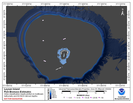
CRED Fish Biomass Estimates map at Laysan Island
National Oceanic and Atmospheric Administration, Department of Commerce —
This map displays fish biomass observation locations overlaid on bathymetry -
Federal
Long-Term Monitoring at the East and West Flower Garden Banks National Marine Sanctuary 2002-2006, (NODC Accession 0012632)
National Oceanic and Atmospheric Administration, Department of Commerce —
The Long-Term Monitoring at the East and West Flower Garden Banks National Marine Sanctuary 2002-2006 data include biological and oceanographic measurements collected...

Official websites use .gov
A
.gov website belongs to an official government
organization in the United States.
Secure .gov websites use HTTPS
A
lock (
) or https:// means you’ve safely connected to
the .gov website. Share sensitive information only on official,
secure websites.