
-
Federal
Fisheries One Stop Shop Public Data 2009 - Present
National Oceanic and Atmospheric Administration, Department of Commerce —
The purpose of the Fisheries One-Stop-Shop (FOSS) is to make fisheries dependent information readily available to fisheries managers, scientists and the American... -
Federal
Surface ocean radial velocities obtained by HF-radar from stations located along coastal waters of Hawaii, North Slope Alaska, Gulf of Alaska, Puerto Rico/Virgin Islands, eastern U.S./Gulf of America, western U.S., and the Great Lakes
National Oceanic and Atmospheric Administration, Department of Commerce —
This dataset contains surface ocean radial velocities data obtained by HF-radar from stations located along coastal waters of the United States. Radial velocity files... -
Federal
Underway physical, meteorological, chemical, and other data collected aboard numerous ships in the NOAA fleet in seas world-wide since February 2012
National Oceanic and Atmospheric Administration, Department of Commerce —
This collection contains underway physical, meteorological, chemical, and other datasets logged by the Scientific Computer System (SCS) aboard ships in the NOAA fleet... -
Federal
AtlanticCanyons2011: Exploration and Research of Mid-Atlantic Deepwater hard Bottom Habitats and Shipwrecks with Emphasis on Canyons and Coral Communities between 20110604 and 20110617
National Oceanic and Atmospheric Administration, Department of Commerce —
This is an interagency study that focuses on the exploration and investigation of deepwater hard bottom biological communities located in the northwest Atlantic Ocean... -
Federal
Sea level measured by tide gauges from global oceans as part of the Joint Archive for Sea Level (JASL) since 1846
National Oceanic and Atmospheric Administration, Department of Commerce —
This collection contains the complete holdings of the Joint Archive for Sea Level (JASL) for hourly and daily data that have been quality controlled, assessed, and... -
Federal
Near-real-time surface ocean velocities derived from HF-radar stations located along coastal waters of North Slope Alaska, Gulf of Alaska, Puerto Rico/Virgin Islands, eastern U.S./Gulf of America, Hawaii, Great Lakes, and western U.S.
National Oceanic and Atmospheric Administration, Department of Commerce —
This dataset contains near-real-time ocean surface velocities, also known as total vector velocities, derived from high-frequency (HF) radar stations. The velocities... -
Federal
F00783: NOS Hydrographic Survey , 2019-08-13
National Oceanic and Atmospheric Administration, Department of Commerce —
The National Oceanic and Atmospheric Administration (NOAA) has the statutory mandate to collect hydrographic data in support of nautical chart compilation for safe... -
Federal
CHIRP Subbottom Profiler Data for the US Atlantic Margin
National Oceanic and Atmospheric Administration, Department of Commerce —
Knudsen 3260 CHIRP subbottom profiler - CHIRP Subbottom Profiler data were collected in Raw Knudsen SEG-Y Datagram format. -
Federal
Understanding the Vulnerabilities of Southeastern Coastal Habitats to Climate Change Impacts - NERRS/NSC(NERRS Science Collaborative)
National Oceanic and Atmospheric Administration, Department of Commerce —
In this project, National Estuarine Research Reserves in North and South Carolina worked to improve local understanding of climate change effects on southeastern salt... -
Federal
Broad River, SC (S110) Bathymetric Digital Elevation Model (30 meter resolution) Derived From Source Hydrographic Survey Soundings Collected by NOAA
National Oceanic and Atmospheric Administration, Department of Commerce —
Bathymetry for the Broad River was derived from twenty-three surveys containing 98,479 soundings. No surveys were omitted. The average separation between soundings... -
Federal
Advancing Low Impact Development in Coastal South Carolina - NERRS/NSC(NERRS Science Collaborative)
National Oceanic and Atmospheric Administration, Department of Commerce —
Known for its beautiful beaches and marshlands, coastal South Carolina has seen a 20 percent population increase over the past decades, which in turn has led to an... -
Federal
Bringing Shorelines to Life in South Carolina - NERRS/NSC(NERRS Science Collaborative)
National Oceanic and Atmospheric Administration, Department of Commerce —
In South Carolina, the Eastern oyster is an ecosystem âall-star.â It filters huge volumes of water, creates habitat for commercial and recreational fisheries, and... -
Federal
Mud on the Move: Predicting How Marshes Will Change as Sea Levels Rise - NERRS/NSC(NERRS Science Collaborative)
National Oceanic and Atmospheric Administration, Department of Commerce —
Healthy tidal marshes support the food webs that underpin our fisheries; they mitigate the impact of coastal storms, and they improve water quality. However, as sea... -
Federal
Santee River, SC (S070) Bathymetric Digital Elevation Model (30 meter resolution) Derived From Source Hydrographic Survey Soundings Collected by NOAA
National Oceanic and Atmospheric Administration, Department of Commerce —
Bathymetry for the Santee River was derived from two surveys containing 11,079 soundings. No surveys were omitted. The average separation between soundings was 40... -
Federal
Modeling Stormwater Impacts in Coastal South Carolina - NERRS/NSC(NERRS Science Collaborative)
National Oceanic and Atmospheric Administration, Department of Commerce —
Coastal South Carolinaâs population is on the rise. As development to support this growth increases, communities must contend with the increase in stormwater runoff... -
Federal
Winyah Bay, SC (S060) Bathymetric Digital Elevation Model (30 meter resolution) Derived From Source Hydrographic Survey Soundings Collected by NOAA
National Oceanic and Atmospheric Administration, Department of Commerce —
Bathymetry for Winyah Bay was derived from eight surveys containing 33,974 soundings. No surveys were omitted. The average separation between soundings was 49 meters.... -
Federal
Bridging the Gap between Quadrats and Satellites: Assessing Utility of Drone-based Imagery to Enhance Emergent Vegetation Biomonitoring - NERRS/NSC(NERRS Science Collaborative)
National Oceanic and Atmospheric Administration, Department of Commerce —
Monitoring plays a central role in detecting change in coastal ecosystems. The National Estuarine Research Reserve System (NERRS) invests heavily in assessing changes... -
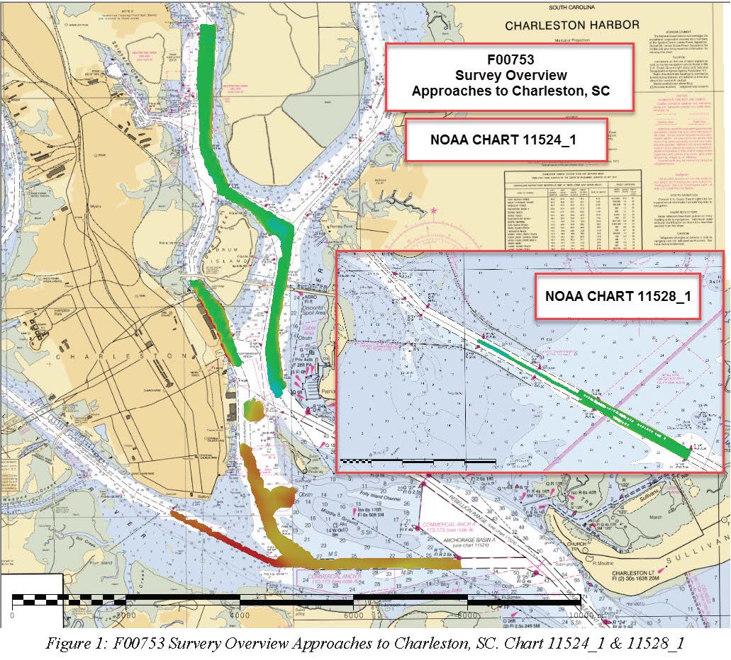
Federal
F00753: NOS Hydrographic Survey , 2018-10-23
National Oceanic and Atmospheric Administration, Department of Commerce —
The National Oceanic and Atmospheric Administration (NOAA) has the statutory mandate to collect hydrographic data in support of nautical chart compilation for safe... -
Federal
Understanding South Carolina's "Swash Cycle" - NERRS/NSC(NERRS Science Collaborative)
National Oceanic and Atmospheric Administration, Department of Commerce —
Myrtle Beach is an economic pearl in South Carolinaâs grand strand, a sixty-mile stretch of beaches and resort communities that support a multi-billion dollar... -
Federal
Connecting the Dots between Data and Atlantic Fisheries Management - NERRS/NSC(NERRS Science Collaborative)
National Oceanic and Atmospheric Administration, Department of Commerce —
Changes in coastal conditions, including those associated with a shifting climate, can impact the spawning, growth, and ultimately, survival of commercially and...

Official websites use .gov
A
.gov website belongs to an official government
organization in the United States.
Secure .gov websites use HTTPS
A
lock (
) or https:// means you’ve safely connected to
the .gov website. Share sensitive information only on official,
secure websites.