
-
Federal
Fisheries One Stop Shop Public Data 2009 - Present
National Oceanic and Atmospheric Administration, Department of Commerce —
The purpose of the Fisheries One-Stop-Shop (FOSS) is to make fisheries dependent information readily available to fisheries managers, scientists and the American... -
Federal
Surface ocean radial velocities obtained by HF-radar from stations located along coastal waters of Hawaii, North Slope Alaska, Gulf of Alaska, Puerto Rico/Virgin Islands, eastern U.S./Gulf of America, western U.S., and the Great Lakes
National Oceanic and Atmospheric Administration, Department of Commerce —
This dataset contains surface ocean radial velocities data obtained by HF-radar from stations located along coastal waters of the United States. Radial velocity files... -
Federal
Underway physical, meteorological, chemical, and other data collected aboard numerous ships in the NOAA fleet in seas world-wide since February 2012
National Oceanic and Atmospheric Administration, Department of Commerce —
This collection contains underway physical, meteorological, chemical, and other datasets logged by the Scientific Computer System (SCS) aboard ships in the NOAA fleet... -
Federal
CTD and sound speed profile data acquired in support of hydrographic multibeam surveys to meet NOAA/NOS, Office of Coast Survey charting requirements
National Oceanic and Atmospheric Administration, Department of Commerce —
Multiple sensors are used to acquire sound speed profiles in the survey areas assigned to the ships and navigation response teams. Some vessels have CTDs and acquire... -
Federal
Bogue Sound, NC (S030) Bathymetric Digital Elevation Model (30 meter resolution) Derived From Source Hydrographic Survey Soundings Collected by NOAA
National Oceanic and Atmospheric Administration, Department of Commerce —
Bathymetry for Bogue Sound was derived from eleven surveys containing 52,366 soundings. Two older, overlapping, less accurate surveys were entirely omitted. The... -
Federal
Sea level measured by tide gauges from global oceans as part of the Joint Archive for Sea Level (JASL) since 1846
National Oceanic and Atmospheric Administration, Department of Commerce —
This collection contains the complete holdings of the Joint Archive for Sea Level (JASL) for hourly and daily data that have been quality controlled, assessed, and... -
Federal
Chirp Subbottom Profiler Data Collected in Pamlico Sound on Cruise RVRiggs_09_29_30_2011 of RV Riggs for the Coastal Hydrodynamics and Natural Geologic Evolution (CHaNGE) Project
National Oceanic and Atmospheric Administration, Department of Commerce —
Edgetech 216 chirp data (SEG-Y format) collected for the Coastal Hydrodynamics and Natural Geologic Evolution (CHaNGE) project, OCE-1130843. Survey area covers... -
Federal
Near-real-time surface ocean velocities derived from HF-radar stations located along coastal waters of North Slope Alaska, Gulf of Alaska, Puerto Rico/Virgin Islands, eastern U.S./Gulf of America, Hawaii, Great Lakes, and western U.S.
National Oceanic and Atmospheric Administration, Department of Commerce —
This dataset contains near-real-time ocean surface velocities, also known as total vector velocities, derived from high-frequency (HF) radar stations. The velocities... -
Federal
Cape Fear River, NC (S050) Bathymetric Digital Elevation Model (30 meter resolution) Derived From Source Hydrographic Survey Soundings Collected by NOAA
National Oceanic and Atmospheric Administration, Department of Commerce —
Bathymetry for the Cape Fear River was derived from seven surveys containing 34,390 soundings. No surveys were omitted. The average separation between soundings was... -
Federal
Chirp Subbottom Profiler Data Collected in Pamlico Sound on Cruise RVRiggs_07_31_2013 of RV Riggs for the Coastal Hydrodynamics and Natural Geologic Evolution (CHaNGE) Project
National Oceanic and Atmospheric Administration, Department of Commerce —
Edgetech 216 chirp data (SEG-Y format) collected for the Coastal Hydrodynamics and Natural Geologic Evolution (CHaNGE) project, OCE-1130843. Survey area covers... -
Federal
Chirp subbottom profiler data collected in Pamlico Sound on cruise RVRiggs_07_29_2013 of RV Riggs for the Coastal Hydrodynamics and Natural Geologic Evolution (CHaNGE) project
National Oceanic and Atmospheric Administration, Department of Commerce —
Edgetech 216 chirp data (SEG-Y format) collected for the Coastal Hydrodynamics and Natural Geologic Evolution (CHaNGE) project, OCE-1130843. Survey area covers... -
Federal
Understanding the Vulnerabilities of Southeastern Coastal Habitats to Climate Change Impacts - NERRS/NSC(NERRS Science Collaborative)
National Oceanic and Atmospheric Administration, Department of Commerce —
In this project, National Estuarine Research Reserves in North and South Carolina worked to improve local understanding of climate change effects on southeastern salt... -
Federal
Chirp subbottom profiler data collected in Pamlico Sound on cruise EPamSh-2016 of RV Riggs for the Coastal Hydrodynamics and Natural Geologic Evolution (CHaNGE) project
National Oceanic and Atmospheric Administration, Department of Commerce —
Edgetech 216 chirp data (SEG-Y format) collected for the Coastal Hydrodynamics and Natural Geologic Evolution (CHaNGE) project, OCE-1130843. Survey area covers... -
Federal
Chirp Subbottom Profiler Data Collected in Pamlico Sound on Cruise RVRiggs_05_23_24_2012 of RV Riggs for the Coastal Hydrodynamics and Natural Geologic Evolution (CHaNGE) project
National Oceanic and Atmospheric Administration, Department of Commerce —
Edgetech 216 chirp data (SEG-Y format) collected for the Coastal Hydrodynamics and Natural Geologic Evolution (CHaNGE) project, OCE-1130843. Survey area covers... -
Federal
Chirp Subbottom Profiler Data Collected in Pamlico Sound on Cruise SndPt_05_21_22_2012 of RV Riggs for the Coastal Hydrodynamics and Natural Geologic Evolution (CHaNGE) Project
National Oceanic and Atmospheric Administration, Department of Commerce —
Edgetech 216 chirp data (SEG-Y format) collected for the Coastal Hydrodynamics and Natural Geologic Evolution (CHaNGE) project, OCE-1130843. Survey area covers... -
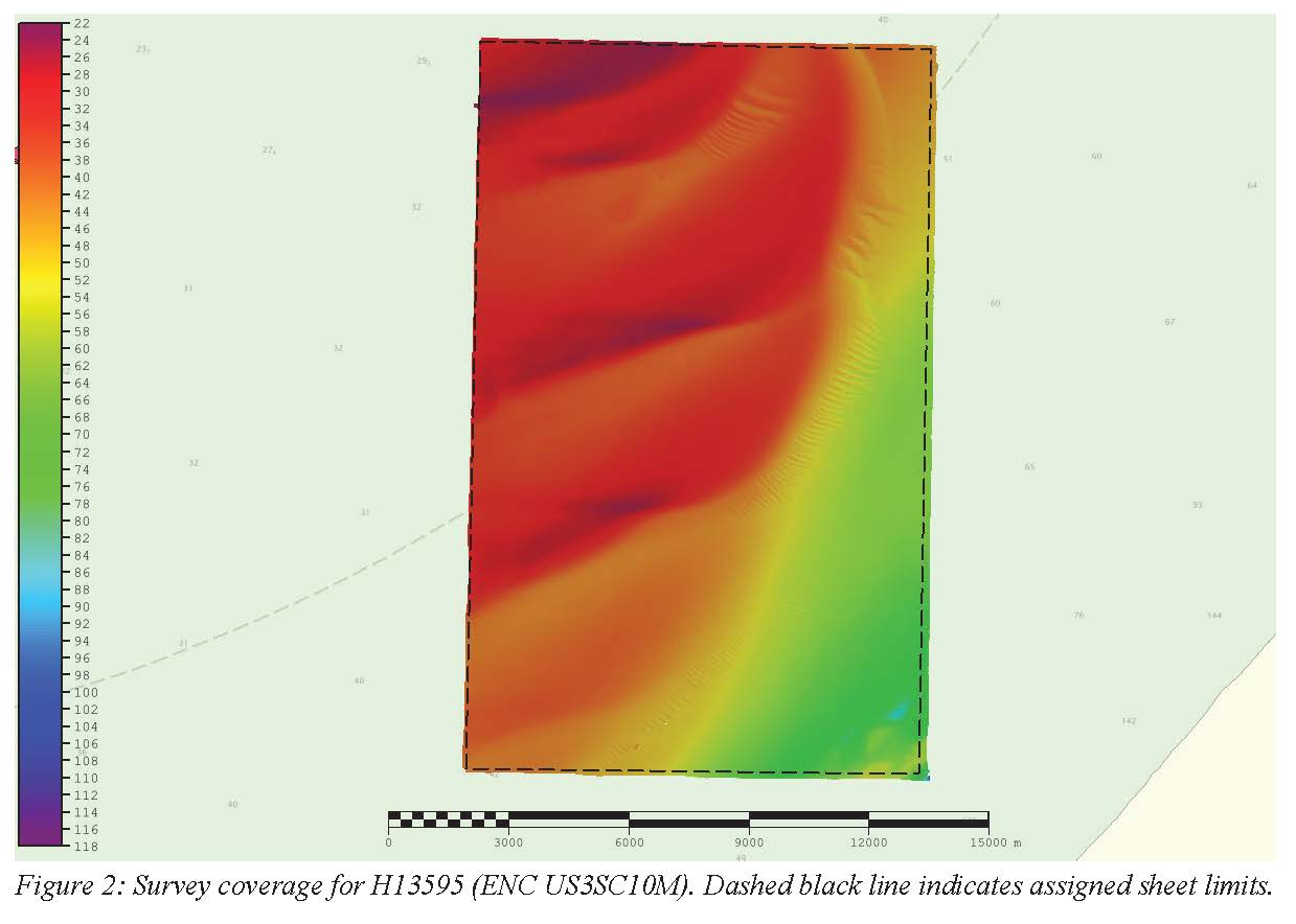
Federal
H13595: NOS Hydrographic Survey , 2022-08-13
National Oceanic and Atmospheric Administration, Department of Commerce —
The National Oceanic and Atmospheric Administration (NOAA) has the statutory mandate to collect hydrographic data in support of nautical chart compilation for safe... -
Federal
H13597: NOS Hydrographic Survey , 2022-10-10
National Oceanic and Atmospheric Administration, Department of Commerce —
The National Oceanic and Atmospheric Administration (NOAA) has the statutory mandate to collect hydrographic data in support of nautical chart compilation for safe... -
Federal
Chirp Subbottom Profiler Data Collected in Pamlico Sound on Cruise RVRiggs_05_20_22_2014 of RV Riggs for the Coastal Hydrodynamics and Natural Geologic Evolution (CHaNGE) Project
National Oceanic and Atmospheric Administration, Department of Commerce —
Edgetech 216 chirp data (SEG-Y format) collected for the Coastal Hydrodynamics and Natural Geologic Evolution (CHaNGE) project, OCE-1130843. Survey area covers the... -
Federal
Exploring Applications of Ecosystem Service Conceptual Models for Coastal Habitats - NERRS/NSC(NERRS Science Collaborative)
National Oceanic and Atmospheric Administration, Department of Commerce —
People receive numerous benefits from nature, such as water purification, coastal protection, and food production. These ecosystem services are an increasingly...

Official websites use .gov
A
.gov website belongs to an official government
organization in the United States.
Secure .gov websites use HTTPS
A
lock (
) or https:// means you’ve safely connected to
the .gov website. Share sensitive information only on official,
secure websites.