
-
Federal
Fisheries One Stop Shop Public Data 2009 - Present
National Oceanic and Atmospheric Administration, Department of Commerce —
The purpose of the Fisheries One-Stop-Shop (FOSS) is to make fisheries dependent information readily available to fisheries managers, scientists and the American... -
Federal
Surface ocean radial velocities obtained by HF-radar from stations located along coastal waters of Hawaii, North Slope Alaska, Gulf of Alaska, Puerto Rico/Virgin Islands, eastern U.S./Gulf of America, western U.S., and the Great Lakes
National Oceanic and Atmospheric Administration, Department of Commerce —
This dataset contains surface ocean radial velocities data obtained by HF-radar from stations located along coastal waters of the United States. Radial velocity files... -
Federal
Underway physical, meteorological, chemical, and other data collected aboard numerous ships in the NOAA fleet in seas world-wide since February 2012
National Oceanic and Atmospheric Administration, Department of Commerce —
This collection contains underway physical, meteorological, chemical, and other datasets logged by the Scientific Computer System (SCS) aboard ships in the NOAA fleet... -
Federal
CTD and sound speed profile data acquired in support of hydrographic multibeam surveys to meet NOAA/NOS, Office of Coast Survey charting requirements
National Oceanic and Atmospheric Administration, Department of Commerce —
Multiple sensors are used to acquire sound speed profiles in the survey areas assigned to the ships and navigation response teams. Some vessels have CTDs and acquire... -
Federal
Water Quality, Nutrients and Chlorophyll Data in Biscayne Bay, Government Cut and Offshore Reefs (NCEI Accession 0248362)
National Oceanic and Atmospheric Administration, Department of Commerce —
The dataset is from monthly Biscayne Bay Water Quality Sampling. Sites were selected to overlap with locations occupied by FDEP and DERM in order to increase temporal... -
Federal
NOAA RESTORE Science Program: A Web-based Interactive Decision-Support Tool for Adaptation of Coastal Urban and Natural Ecosystems (ACUNE) in Southwest Florida: Flood Maps for current conditions, 2030, 2060, and 2100 under different sea level rise scenarios (NCEI Accession 0248802)
National Oceanic and Atmospheric Administration, Department of Commerce —
This dataset contains probabilistic (return-period based) flood maps from storm surge, tide and waves. The maps were produced by the Joint Probability Method with... -
Federal
St. Johns River, FL (S180) Bathymetric Digital Elevation Model (30 meter resolution) Derived From Source Hydrographic Survey Soundings Collected by NOAA
National Oceanic and Atmospheric Administration, Department of Commerce —
Bathymetry for the St. Johns River was derived from thirty-two surveys containing 158,931 soundings. No surveys were omitted. The average separation between soundings... -
Federal
NCCOS Assessment: Investigating the effects of chronic turbidity exposure to priority Florida coral species, Orbicella faveolata 2023-09-19 to 2023-12-12 (NCEI Accession 0303582)
National Oceanic and Atmospheric Administration, Department of Commerce —
This dataset is comprised of many biochemical analyses performed throughout the course of a 90-day laboratory exposure experiments to determine the chronic effects of... -
Federal
Sea level measured by tide gauges from global oceans as part of the Joint Archive for Sea Level (JASL) since 1846
National Oceanic and Atmospheric Administration, Department of Commerce —
This collection contains the complete holdings of the Joint Archive for Sea Level (JASL) for hourly and daily data that have been quality controlled, assessed, and... -
Federal
NOAA RESTORE Science Program: Gulf-wide assessment of habitat use and habitat-specific production estimates of nekton in turtlegrass (Thalassia testudinum): Nekton and primary producer stable isotopes in turtlegrass-dominated seagrass beds in the northern Gulf of America, 2018-05-23 to 2018-10-03 (NCEI Accession 0304846)
National Oceanic and Atmospheric Administration, Department of Commerce —
This dataset consists of stable isotope data from turtlegrass-dominated seagrass beds of the northern Gulf of America (formally the Gulf of Mexico), including Lower... -
Federal
Near-real-time surface ocean velocities derived from HF-radar stations located along coastal waters of North Slope Alaska, Gulf of Alaska, Puerto Rico/Virgin Islands, eastern U.S./Gulf of America, Hawaii, Great Lakes, and western U.S.
National Oceanic and Atmospheric Administration, Department of Commerce —
This dataset contains near-real-time ocean surface velocities, also known as total vector velocities, derived from high-frequency (HF) radar stations. The velocities... -
Federal
NCCOS Assessment: Investigating the effects of chronic turbidity exposure with elevated temperature to priority Florida coral species, Orbicella faveolata 2024-02-13 to 2024-05-07 (NCEI Accession 0304024)
National Oceanic and Atmospheric Administration, Department of Commerce —
This dataset is comprised of multiple analyses from a 90-day laboratory exposure experiment to determine the chronic effects of fine-sediment generated turbidity in... -
Federal
Stakeholder-Driven Modeling to Understand Oyster Population Sustainability - NERRS/NSC(NERRS Science Collaborative)
National Oceanic and Atmospheric Administration, Department of Commerce —
The Eastern oyster (Crassostrea virginica) is a keystone species in northeast Florida estuaries, including the Guana Tolomato Matanzas (GTM) Reserve. However,... -
Federal
F00868: NOS Hydrographic Survey , 2022-09-30
National Oceanic and Atmospheric Administration, Department of Commerce —
The National Oceanic and Atmospheric Administration (NOAA) has the statutory mandate to collect hydrographic data in support of nautical chart compilation for safe... -
Federal
H12357: NOS Hydrographic Survey , 2014-01-06
National Oceanic and Atmospheric Administration, Department of Commerce —
The National Oceanic and Atmospheric Administration (NOAA) has the statutory mandate to collect hydrographic data in support of nautical chart compilation for safe... -
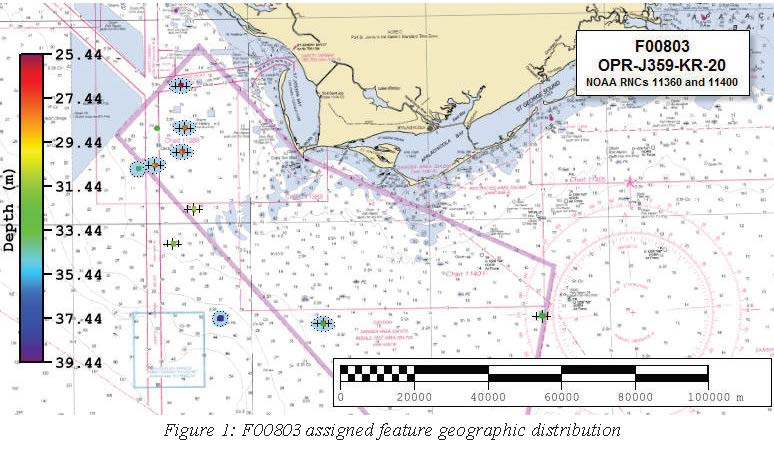
Federal
F00803: NOS Hydrographic Survey , 2020-06-28
National Oceanic and Atmospheric Administration, Department of Commerce —
The National Oceanic and Atmospheric Administration (NOAA) has the statutory mandate to collect hydrographic data in support of nautical chart compilation for safe... -
Federal
F00629: NOS Hydrographic Survey , St. Augustine, FL, 2013-04-09
National Oceanic and Atmospheric Administration, Department of Commerce —
The National Oceanic and Atmospheric Administration (NOAA) has the statutory mandate to collect hydrographic data in support of nautical chart compilation for safe... -
Federal
NCCOS Assessment: Investigating the effects of chronic turbidity exposure to priority Florida coral species, Acropora cervicornis 2023-08-15 to 2023-11-07 (NCEI Accession 0309260)
National Oceanic and Atmospheric Administration, Department of Commerce —
This dataset is comprised of many biochemical analyses performed throughout the course of a 90-day laboratory exposure experiments to determine the chronic effects of... -
Federal
Assessing the Current and Potential Role of Shellfish for Improving Water Quality - NERRS/NSC(NERRS Science Collaborative)
National Oceanic and Atmospheric Administration, Department of Commerce —
By leveraging reserve capacity and deepening relationships, this project fostered connectedness between people and data to strengthen water quality restoration... -
Federal
CHIRP Subbottom Profiler Data for the US Atlantic Margin
National Oceanic and Atmospheric Administration, Department of Commerce —
Knudsen 3260 CHIRP subbottom profiler - CHIRP Subbottom Profiler data were collected in Raw Knudsen SEG-Y Datagram format.

Official websites use .gov
A
.gov website belongs to an official government
organization in the United States.
Secure .gov websites use HTTPS
A
lock (
) or https:// means you’ve safely connected to
the .gov website. Share sensitive information only on official,
secure websites.