
-
Federal
CORONA Satellite Photography
National Aeronautics and Space Administration —
On February 24, 1995, President Clinton signed an Executive Order, directing the declassification of intelligence imagery acquired by the first generation of United... -
Federal
Landsat 8
National Aeronautics and Space Administration —
The Operational Land Imager (OLI) and Thermal Infrared Sensor (TIRS) are onboard the Landsat 8 satellite, have acquired images of the Earth since February 2013. The... -
Federal
USGS Digital Orthophoto Quadrangles
National Aeronautics and Space Administration —
A Digital Orthophoto Quadrangle (DOQ) is a computer-generated image of an aerial photograph in which the image displacement caused by terrain relief and camera tilt... -
Federal
CORONA Satellite Photographs from the U.S. Geological Survey
National Aeronautics and Space Administration —
The first generation of U.S. photo intelligence satellites collected more than 860,000 images of the Earth’s surface between 1960 and 1972. The classified military... -
Federal
Global Land Cover Characterization Program
National Aeronautics and Space Administration —
The Global Land Cover Characterization Project was established to meet science data requirements identified by the International Geosphere and Biosphere Programme... -
Federal
High-Resolution QuickBird Imagery and Related GIS Layers for Barrow, Alaska, USA, Version 1
National Aeronautics and Space Administration —
This data set contains high-resolution QuickBird imagery and geospatial data for the entire Barrow QuickBird image area (156.15° W - 157.07° W, 71.15° N - 71.41° N)... -
Federal
IceBridge DMS L1B Geolocated and Orthorectified Images V001
National Aeronautics and Space Administration —
This data set contains Level-1B imagery taken from the Digital Mapping System (DMS) over Greenland and Antarctica. The data were collected as part of Operation... -
Federal
EO-1 Hyperion
National Aeronautics and Space Administration —
The Earth-Observing One (EO-1) satellite was decommissioned March 2017. The EO-1 satellite was launched on November 21, 2000 with the NASA's New Millennium Program... -
Federal
National High Altitude Photography
National Aeronautics and Space Administration —
The National High Altitude Photography (NHAP) program, which was operated from 1980 - 1989, was coordinated by the U.S. Geological Survey as an interagency project to... -
Federal
GOES-R PLT Airborne Visible/Infrared Imaging Spectrometer (AVIRIS) V1
National Aeronautics and Space Administration —
The GOES-R PLT Airborne Visible/Infrared Imaging Spectrometer (AVIRIS) dataset consists of radiance, reflectance, water phase, and navigation data delivered by the... -
Federal
NASA Landsat Data Collection
National Aeronautics and Space Administration —
The NASA Landsat Data Collection (NLDC) is a compilation of Landsat multispectral scanner (MSS) scenes and Landsat thematic mapper (TM) scenes. This compilation of... -
Federal
IceBridge DMS L3 Ames Stereo Pipeline Orthorectified Images V001
National Aeronautics and Space Administration —
This data set represents a collection of orthorectified images obtained by processing Operation IceBridge DMS stereo images and lidar data using the NASA Ames Stereo... -
Federal
Advanced Spaceborne Thermal Emission and Reflection Radiometer (ASTER) NGDA
National Aeronautics and Space Administration —
This dataset represents multiple products archived at the Land Processes DAAC for ASTER (Advanced Spaceborne Thermal Emission and Reflection Radiometer) aboard the... -
Federal
VIIRS/JPSS2 Moderate Resolution 6 Min L1B Swath 750 m
National Aeronautics and Space Administration —
The VIIRS/JPSS2 Moderate Resolution 6-Min L1B Swath 750m, short-name VJ202MOD is the Joint Polar-orbiting Satellite System-2 (JPSS-2/NOAA-21; referred to hereafter as... -
Federal
International Space Station SERVIR Environmental Research and Visualization System V1
National Aeronautics and Space Administration —
Abstract: The ISS SERVIR Environmental Research and Visualization System (ISERV) acquired images of the Earth's surface from the International Space Station (ISS).... -
Federal
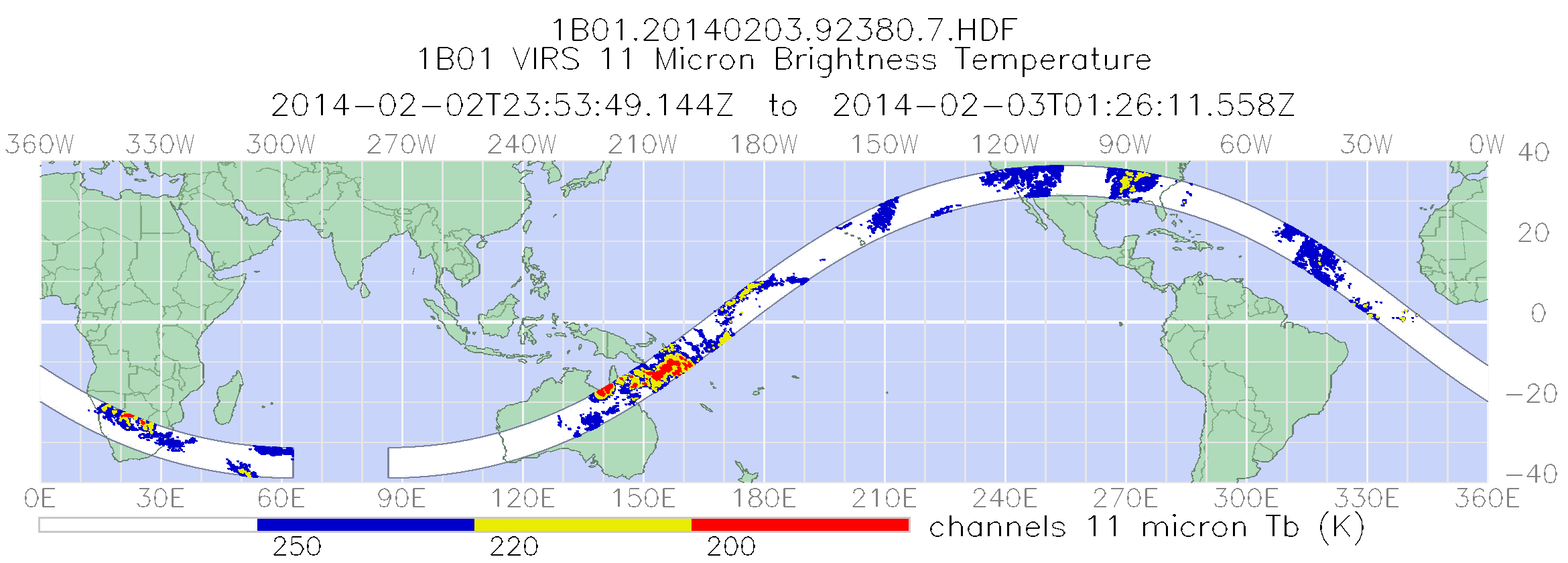
TRMM Visible and Infrared Scanner Calibrated Radiances L1B 1.5 hours V7 (TRMM_1B01) at GES DISC
National Aeronautics and Space Administration —
This TRMM Visible and Infrared Scanner (VIRS) Level 1B Calibrated Radiance Product (1B01) contains calibrated radiances and auxiliary geolocation information from the... -
Federal
IceBridge LVIS L1A Geotagged Images V001
National Aeronautics and Space Administration —
This data set contains geotagged images taken over Greenland and Antarctica by the NASA Digital Mapping Camera paired with the Land, Vegetation, and Ice Sensor... -
Federal
TRMM Visible and Infrared Scanner Calibrated Radiances L1B 1.5 hours V7 (TRMM_1B01) at GES DISC
National Aeronautics and Space Administration —
This TRMM Visible and Infrared Scanner (VIRS) Level 1B Calibrated Radiance Product (1B01) contains calibrated radiances and auxiliary geolocation information from the... -
Federal
Multi-Resolution Land Characteristics
National Aeronautics and Space Administration —
The Multi-Resolution Land Characteristics (MRLC) project was established to provide multi-resolution land cover data of the conterminous United States from local to...

Official websites use .gov
A
.gov website belongs to an official government
organization in the United States.
Secure .gov websites use HTTPS
A
lock (
) or https:// means you’ve safely connected to
the .gov website. Share sensitive information only on official,
secure websites.