
-
Federal
ASTER Global DEM NGDA
National Aeronautics and Space Administration —
ASTER is capable of collecting in-track stereo using nadir- and aft-looking near infrared cameras. Since 2001, these stereo pairs have been used to produce single-... -
Federal
Moderate Resolution Imaging Spectroradiometer (MODIS) - Terra NGDA
National Aeronautics and Space Administration —
This dataset represents multiple products archived at the multiple archive centers for the MODIS (Moderate Resolution Imaging Spectroradiometer) instrument aboard the... -
Federal
MODIS/Aqua Sea Ice Extent Daily L3 Global 1km EASE-Grid Day V061 NGDA
National Aeronautics and Space Administration —
This global Level-3 (L3) data set provides daily daytime sea ice extent and ice surface temperature derived from the 'MODIS/Aqua Sea Ice Extent 5-Min L2 Swath 1km'... -
Federal
CERES and GEO-Enhanced TOA, Within-Atmosphere and Surface Fluxes, Clouds and Aerosols 3-Hourly Terra-Aqua Edition4A NGDA
National Aeronautics and Space Administration —
CER_SYN1deg-3Hour_Terra-Aqua-MODIS_Edition4A is the Clouds and the Earth's Radiant Energy System (CERES) and geostationary (GEO)-Enhanced Top of Atmosphere (TOA),... -
Federal
Aqua MODIS Global Mapped Chlorophyll (CHL) - NRT Data, version R2022.0 NGDA
National Aeronautics and Space Administration —
The Ocean Biology DAAC produces near real-time (quicklook) products using the best-available combination of ancillary data from meteorological and ozone data. As... -
Federal
Moderate Resolution Imaging Spectroradiometer (MODIS) - Aqua NGDA
National Aeronautics and Space Administration —
This dataset represents multiple products archived at the multiple archive centers for the MODIS (Moderate Resolution Imaging Spectroradiometer) instrument aboard the... -
Federal
Advanced Spaceborne Thermal Emission and Reflection Radiometer (ASTER) NGDA
National Aeronautics and Space Administration —
This dataset represents multiple products archived at the Land Processes DAAC for ASTER (Advanced Spaceborne Thermal Emission and Reflection Radiometer) aboard the... -
Federal
Aqua MODIS Level-3 Global Mapped 11µm Daytime Sea Surface Temperature (SST) Data, version R2019.0 NGDA
National Aeronautics and Space Administration —
MODIS (or Moderate-Resolution Imaging Spectroradiometer) is a key instrument aboard the Terra (EOS AM) and Aqua (EOS PM) satellites. Terra's orbit around the Earth is... -
Federal
Moderate Resolution Imaging Spectroradiometer (MODIS) - Terra NGDA
National Aeronautics and Space Administration —
This dataset represents multiple products archived at the multiple archive centers for the MODIS (Moderate Resolution Imaging Spectroradiometer) instrument aboard the... -
Federal
Moderate Resolution Imaging Spectroradiometer (MODIS) - Aqua NGDA
National Aeronautics and Space Administration —
This dataset represents multiple products archived at the multiple archive centers for the MODIS (Moderate Resolution Imaging Spectroradiometer) instrument aboard the... -
Federal
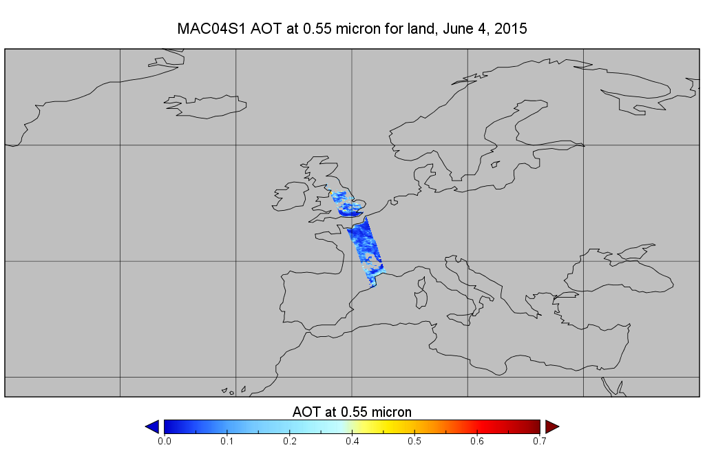
MODIS/Aqua Aerosol 10km 5-Min L2 Wide Swath Subset along CloudSat V002 (MAC04S1) at GES DISC NGDA
National Aeronautics and Space Administration —
This is the wide-swath MODIS/Aqua subset along CloudSat field of view track. The goal of the wide-swath subset is to select and return MODIS data that are within... -
Federal
2015 Urban Extents from VIIRS and MODIS for the Continental U.S. Using Machine Learning Methods NGDA
National Aeronautics and Space Administration —
The 2015 Urban Extents from VIIRS and MODIS for the Continental U.S. Using Machine Learning Methods data set models urban settlements in the Continental United States... -
Federal
MODIS/Aqua Sea Ice Extent and IST Daily L3 Global 4km EASE-Grid Day V061 NGDA
National Aeronautics and Space Administration —
This global Level-3 (L3) data set provides Northern and Southern Hemisphere maps of sea ice extent and ice surface temperature. The maps are generated by compositing... -
Federal
Terra MODIS Level-3 Global Mapped 4µm Nighttime Sea Surface Temperature (SST4) Data, version R2019.0 NGDA
National Aeronautics and Space Administration —
MODIS (or Moderate-Resolution Imaging Spectroradiometer) is a key instrument aboard the Terra (EOS AM) and Aqua (EOS PM) satellites. Terra's orbit around the Earth is... -
Federal
Terra MODIS Level-3 Global Binned 4µm Day/Night Sea Surface Temperature (SST4) - Near Real-time (NRT) Data, version R2019.0 NGDA
National Aeronautics and Space Administration —
The Ocean Biology DAAC produces near real-time (quicklook) products using the best-available combination of ancillary data from meteorological and ozone data. As... -
Federal
Terra MODIS Level-3 Global Mapped 4µm Day/Night Sea Surface Temperature (SST4) - Near Real-time (NRT) Data, version R2019.0 NGDA
National Aeronautics and Space Administration —
The Ocean Biology DAAC produces near real-time (quicklook) products using the best-available combination of ancillary data from meteorological and ozone data. As... -
Federal
Aqua MODIS Level-3 Global Mapped 11µm Nighttime Sea Surface Temperature (NSST) Data, version R2019.0 NGDA
National Aeronautics and Space Administration —
MODIS (or Moderate-Resolution Imaging Spectroradiometer) is a key instrument aboard the Terra (EOS AM) and Aqua (EOS PM) satellites. Terra's orbit around the Earth is... -
Federal
MODIS/Terra Snow Cover Daily L3 Global 500m SIN Grid V061 NGDA
National Aeronautics and Space Administration —
This global Level-3 (L3) data set provides a daily composite of snow cover and albedo derived from the 'MODIS/Terra Snow Cover 5-Min L2 Swath 500m' data set... -
Federal
MODIS/Terra Global Annual 0.01Deg CMG Snow Cover Climatology V001 NGDA
National Aeronautics and Space Administration —
This data set presents new global snow cover classification regimes derived from the MODIS Terra cloud gap-filled NDSI data (MOD10A1F), elevation, and temperature... -
Federal
Multilayer Greenland Ice Surface Temperature, Surface Albedo, and Water Vapor from MODIS V001 NGDA
National Aeronautics and Space Administration —
This multilayer data set includes standard MODIS Collection 6.1 ice surface temperature (IST) and derived melt map, as well as MODIS Collection 6.0 albedo and water...

Official websites use .gov
A
.gov website belongs to an official government
organization in the United States.
Secure .gov websites use HTTPS
A
lock (
) or https:// means you’ve safely connected to
the .gov website. Share sensitive information only on official,
secure websites.