
-
Federal
Global Man-made Impervious Surface (GMIS) Dataset From Landsat
National Aeronautics and Space Administration —
The Global Man-made Impervious Surface (GMIS) Dataset From Landsat consists of global estimates of fractional impervious cover derived from the Global Land Survey... -
Federal
China Dimensions Data Collection: China Maps Bibliographic Database
National Aeronautics and Space Administration —
The China Maps Bibliographic Database is an historical collection of bibliographic information for more than 400 maps of China. The information resides in a... -
Federal
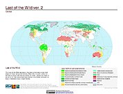
Last of the Wild Project, Version 2, 2005 (LWP-2): Global Human Footprint Dataset (Geographic)
National Aeronautics and Space Administration —
The Global Human Footprint Dataset of the Last of the Wild Project, Version 2, 2005 (LWP-2) is the Human Influence Index (HII) normalized by biome and realm. The HII... -
Federal
Last of the Wild Project, Version 3 (LWP-3): 2009 Human Footprint, 2018 Release
National Aeronautics and Space Administration —
The 2009 Human Footprint, 2018 Release provides a global map of the cumulative human pressure on the environment in 2009, at a spatial resolution of ~1 km. The human... -
Federal
Millennium Ecosystem Assessment: MA Ecosystems
National Aeronautics and Space Administration —
The Millennium Ecosystem Assessment: MA Ecosystems provides data and information on the extent and classification of ecosystems circa 2000, including coastal,... -
Federal
Tidal Wetlands Soil Organic Carbon and Estuarine Characteristics, USA, 1972-2015
National Aeronautics and Space Administration —
This dataset provides a synthesis of soil organic carbon (SOC) estimates and a variety of other environmental information from tidal wetlands within estuaries in the... -
Federal
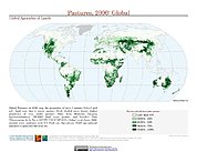
Global Agricultural Lands: Pastures, 2000
National Aeronautics and Space Administration —
The Global Pastures data set represents the proportion of land areas used as pasture land (land used to support grazing animals) in the year 2000. Satellite data from... -
Federal
Last of the Wild Project, Version 1, 2002 (LWP-1): Global Human Footprint Dataset (Geographic)
National Aeronautics and Space Administration —
The Global Human Footprint Dataset of the Last of the Wild Project, Version 1, 2002 (LWP-1) is the Human Influence Index (HII) normalized by biome and realm. The HII... -
Federal
NOAA-20 VIIRS Global Mapped Inherent Optical Properties (IOP) - Near Real-time (NRT) Data, version R2022.0
National Aeronautics and Space Administration —
The Ocean Biology DAAC produces near real-time (quicklook) products using the best-available combination of ancillary data from meteorological and ozone data. As... -
Federal
NOAA-21 VIIRS Global Mapped Inherent Optical Properties (IOP) - Near Real-time (NRT) Data, version R2022.0
National Aeronautics and Space Administration —
The Ocean Biology DAAC produces near real-time (quicklook) products using the best-available combination of ancillary data from meteorological and ozone data. As... -
Federal
Compendium of Environmental Sustainability Indicator Collections: The Wellbeing of Nations
National Aeronautics and Space Administration —
The Wellbeing of Nations portion of the Compendium of Environmental Sustainability Indicator Collections contains a subset of 123 variables assembled from the... -
Federal
Last of the Wild Project, Version 2, 2005 (LWP-2): Last of the Wild Dataset (Geographic)
National Aeronautics and Space Administration —
The Last of the Wild Dataset of the Last of the Wild Project, Version 2, 2005 (LWP-2) is derived from the LWP-2 Human Footprint Dataset. The gridded data are... -
Federal
Sentinel-3A OLCI Regional Mapped Inland Waters (ILW) Data, version 4
National Aeronautics and Space Administration —
The Inland Waters dataset (ILW) provides data for lakes and other water bodies across the contiguous United States (CONUS) and Alaska. ILW significantly reduces the... -
Federal
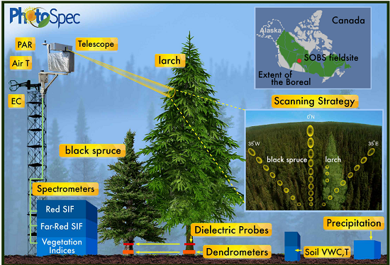
Tower-based PhotoSpec Products for the 2019 and 2020 Spring Transition Season, SK, CA
National Aeronautics and Space Administration —
This dataset includes daily averaged solar-induced chlorophyll fluorescence (SIF) in the red (680-686 nm) and far-red (745-758 nm) wavelength ranges, relative SIF... -
Federal
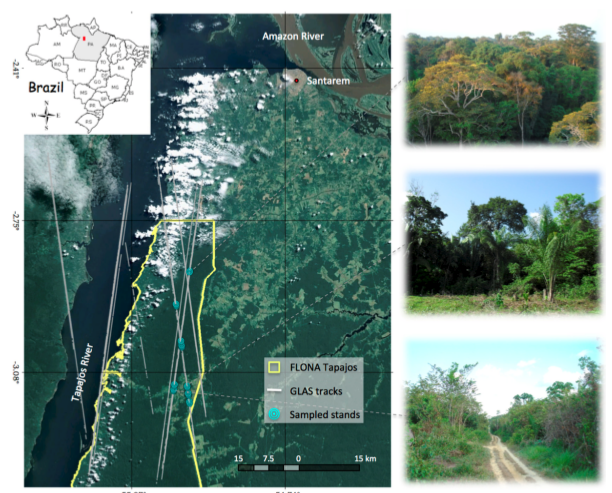
Tree Inventory and Biometry Measurements, Tapajos National Forest, Para, Brazil, 2010
National Aeronautics and Space Administration —
This dataset provides tree inventory, tree height, diameter at breast height (DBH), and estimated crown measurements from 30 plots located in the Tapajos National... -
Federal
Sentinel-3A OLCI Regional Binned Inland Waters (ILW) Data, version 4
National Aeronautics and Space Administration —
The Inland Waters dataset (ILW) provides data for lakes and other water bodies across the contiguous United States (CONUS) and Alaska. ILW significantly reduces the... -
Federal
Last of the Wild Project, Version 1, 2002 (LWP-1): Last of the Wild Dataset (IGHP)
National Aeronautics and Space Administration —
The Last of the Wild Dataset of the Last of the Wild Project, Version 1, 2002 (LWP-1) is derived from the LWP-1 Human Footprint Dataset. The gridded data are... -
Federal
Sentinel-3B OLCI Regional Binned Inland Waters (ILW) Data, version 4
National Aeronautics and Space Administration —
The Inland Waters dataset (ILW) provides data for lakes and other water bodies across the contiguous United States (CONUS) and Alaska. ILW significantly reduces the...

Official websites use .gov
A
.gov website belongs to an official government
organization in the United States.
Secure .gov websites use HTTPS
A
lock (
) or https:// means you’ve safely connected to
the .gov website. Share sensitive information only on official,
secure websites.