
-
Federal
Spitzer Extragalactic First Look Survey SDSS Spectroscopic Catalog
National Aeronautics and Space Administration —
The Extragalactic First Look Survey is composed of 4 square degrees of imaging with MIPS and IRAC centered at J1718+5930, with extensive ancillary data from ground-... -
Federal
INTEGRAL IBIS Hard X-Ray Survey Above 100 keV Source Catalog
National Aeronautics and Space Administration —
This table contains results from an all-sky survey, performed by the Imager on-Board the INTEGRAL Satellite (IBIS) telescope on board the INTErnational Gamma-Ray... -
Federal
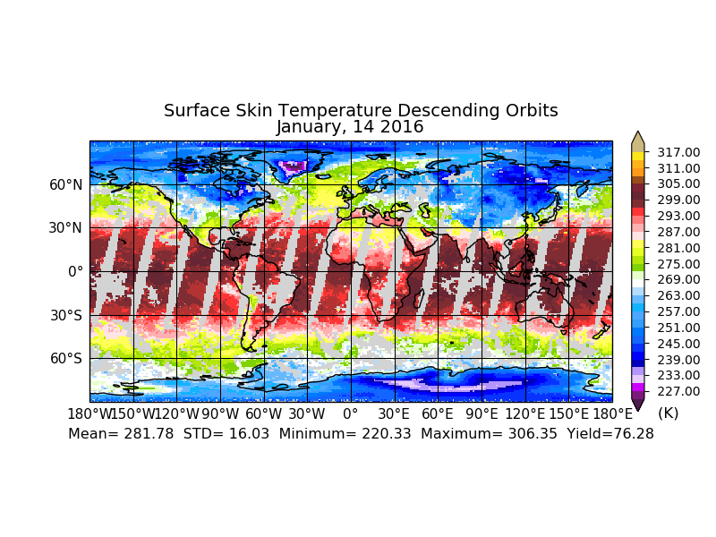
Sounder SIPS: AQUA AIRS IR-only Level 3 CLIMCAPS: Specific Quality Control Gridded Daily V2 (SNDRAQIL3SDCCP) at GES DISC
National Aeronautics and Space Administration —
WARNING: Users of the derived product “co_mmr_midtrop” (carbon monoxide mass mixing ratio to dry air [kg/kg] at ~500 hPa). This variable has a significant bias due to... -
Federal
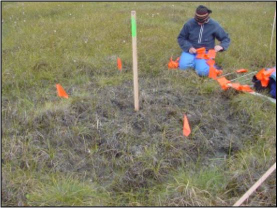
Arctic Vegetation Plots at Frost Boil Sites, North Slope, Alaska, 2000-2006
National Aeronautics and Space Administration —
This data set describes the environment, soil, and vegetation on nonsorted circles and earth hummocks at seven study sites along a N-S-transect from the Arctic Ocean... -
Federal
LAI (Indirect): Light Wand - KSU (FIFE)
National Aeronautics and Space Administration —
The prairie is inherently variable and large numbers of samples are needed to obtain reliable estimates of the prairie agronomic characteristics. For the Indirect... -
Federal
ATTREX Global Hawk UAS In-Situ Trace Gas Measurements
National Aeronautics and Space Administration —
ATTREX-Aircraft_insitu_TraceGas_Measurements are in-situ trace gas measurements collected onboard the Global Hawk Uninhabited Aerial System (UAS) during the Airborne... -
Federal
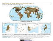
Gridded Population of the World, Version 4 (GPWv4): Administrative Unit Center Points with Population Estimates, Revision 11
National Aeronautics and Space Administration —
The Gridded Population of the World, Version 4 (GPWv4): Administrative Unit Center Points with Population Estimates, Revision 11 consists of UN WPP-adjusted... -
Federal
SnowEx20 Cameron Pass Ground Penetrating Radar Raw V001
National Aeronautics and Space Administration —
This data set contains the raw files from ground-penetrating radar surveys conducted at Cameron Pass, Colorado during the SnowEx20 campaign. Data were collected... -
Federal
ISIS-2 Topside Sounder Average Ionogram over Santiago, Chile: SNT, Latitude -33, Longitude 298
National Aeronautics and Space Administration —
These Ionograms were digitized from the original ISIS-2 7-Track Analog Telemetry Tapes using the Facilities of the former Data Evaluation Laboratory at the NASA/GSFC.... -
Federal
MODIS/Terra Surface Reflectance 8-Day L3 Global 500m SIN Grid V061
National Aeronautics and Space Administration —
The Moderate Resolution Imaging Spectroradiometer (MODIS) Terra MOD09A1 Version 6.1 product provides an estimate of the surface spectral reflectance of Terra MODIS... -
Federal
CERES Monthly Daytime Mean Regionally Averaged NOAA-20 TOA Fluxes and Associated Cloud Properties Stratified by Optical Depth and Effective Pressure Edition1B
National Aeronautics and Space Administration —
CER_FluxByCldTyp-Month_NOAA20-VIIRS_Edition1B is the Clouds and the Earth's Radiant Energy System (CERES) Monthly Daytime Mean Regionally Averaged NOAA-20 Top-of-... -
Federal
GHRSST Level 2P Regional 1m Sea Surface Temperature from the Advanced Very High Resolution Radiometer (AVHRR) on the NOAA-19 satellite produced by NAVO
National Aeronautics and Space Administration —
A regional Group for High Resolution Sea Surface Temperature (GHRSST) Level 2P dataset based on multi-channel sea surface temperature (SST) retrievals generated in... -
Federal
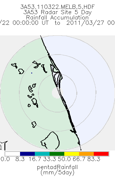
TRMM Ground Validation Radar Site Rain Totals Map L3 5 days 2 km V7 (TRMM_3A53) at GES DISC
National Aeronautics and Space Administration —
This is the 5-day accumulation of the 2A53 product, 'Radar Site Rain Map', which originally is an instantaneous surface rain rate map in Cartesian coordinates with a... -
Federal
IMP 8 Cosmic Ray Nuclear Composition (CRNC) hourly energetic proton fluxes
National Aeronautics and Space Administration —
This data set contains hourly, spin-averaged\nfluxes of protons from the IMP8. Cosmic Ray Nuclear Composition\nexperiment of U. Chicago and UNH. There are are fluxes... -
Federal
ACES Aircraft and Mechanical Data V1
National Aeronautics and Space Administration —
The ACES Aircraft and Mechanical Data consist of aircraft (e.g. pitch, roll, yaw) and mechanical (e.g. aircraft engine speed, tail commands, fuel levels) data... -
Federal
USGS Global Forest Observations Initiative (GFOI) Colombia
National Aeronautics and Space Administration —
The Global Forest Observations Initiative (GFOI) is an initiative of the inter-governmental Group on Earth Observations (GEO) that aims to: foster the sustained... -
Federal
MODIS/Terra Gap-Filled, Smoothed NDVI 8-Day L4 500m SIN Grid
National Aeronautics and Space Administration —
The MODIS/Terra Gap-Filled, Smoothed NDVI 8-Day L4 500m SIN Grid product, with short-name MOD09A1G_NDVI is calculated from MODIS surface reflectance products (MOD09),... -
Federal
Comparative Transcriptomic Analysis of Adult Medaka Tissues Sampled after Adaptation to a Space Environment
National Aeronautics and Space Administration —
To understand how humans adapt to space environments many experiments can be conducted on astronauts while they work aboard the Space Shuttle or the International... -
Federal
Glacier Inventory of West Greenland, 1948 - 1985, Version 1
National Aeronautics and Space Administration —
The inventory includes 5,297 Glaciers from west Greenland between 59 to 71 degrees latitude north and 43 to 53 degrees longitude west. The glacier data basin division... -
Federal
HERITAGE SMC PACS 100 micron Catalog
National Aeronautics and Space Administration —
The HERschel Inventory of The Agents of Galaxy Evolution (HERITAGE) open time key program mapped the Large Magellanic Cloud (LMC) and Small Magellanic Cloud (SMC) at...

Official websites use .gov
A
.gov website belongs to an official government
organization in the United States.
Secure .gov websites use HTTPS
A
lock (
) or https:// means you’ve safely connected to
the .gov website. Share sensitive information only on official,
secure websites.