
-
Federal
['Draft Genome Sequences of Two Fusarium oxysporum Isolates Cultured from Infected Zinnia hybrida Plants Grown on the International Space Station']
National Aeronautics and Space Administration —
['Draft genome sequences of two Fusarium oxysporum isolates cultured from infected Zinnia hybrida plants grown on the International Space Station'] -
Federal
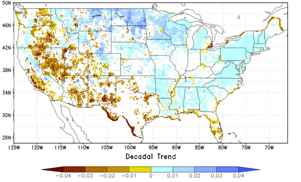
NCA-LDAS Noah-3.3 Land Surface Model L4 Trends 0.125 x 0.125 degree V2.0 (NCALDAS_NOAH0125_Trends) at GES DISC
National Aeronautics and Space Administration —
The National Climate Assessment - Land Data Assimilation System, or NCA-LDAS, is a terrestrial water reanalysis in support of the United States Global Change Research... -
Federal
Alpha Jet Atmospheric eXperiment Formaldehyde Data
National Aeronautics and Space Administration —
The Alpha Jet Atmospheric eXperiment (AJAX) is a partnership between NASA's Ames Research Center and H211, L.L.C., facilitating routine in-situ measurements over... -
Federal
TROPESS CrIS-SNPP L2 for Los Angeles Megacity, Standard Product V1 (TRPSDL2ALLCRSMGLOS) at GES DISC
National Aeronautics and Space Administration —
The TROPESS CrIS-SNPP L2 for Los Angeles Megacity, Standard Product contains the vertical distribution of seven retrieved atmospheric gases (CH4, CO, H2O, HDO, NH3,... -
Federal
AirMOSS: L2/3 Volumetric Soil Moisture Profiles Derived From Radar, 2012-2015
National Aeronautics and Space Administration —
This data set provides level 2/3 root zone soil moisture (RZSM) estimates at multiple depths at 90-m spatial resolution from the Airborne Microwave Observatory of... -
Federal
ABoVE LVIS L2 Geolocated Surface Elevation Product V001
National Aeronautics and Space Administration —
This data set contains surface elevation data over Alaska and Western Canada measured by the NASA Land, Vegetation, and Ice Sensor (LVIS), an airborne lidar scanning... -
Federal
BOREAS TE-23 Map Plot Data
National Aeronautics and Space Administration —
The BOREAS TE-23 team collected map plot data in support of its efforts to characterize and interpret information on canopy architecture and understory cover at the... -
Federal
The Seven-Year Swift-XRT Point Source Catalog (1SWXRT)
National Aeronautics and Space Administration —
This table contains the 1SWXRT catalog of point sources detected by X-ray Telescope (XRT) on board of the Swift satellite during the first seven years of operation... -
Federal
AIRSAR_TOPSAR_DEM_C
National Aeronautics and Space Administration —
AIRSAR topographic SAR digital elevation model CTIF product -
Federal
TWINS 1 Images of Plasma Sheet Ion Temperature during Storms calculated from Energetic Neutral Atom (ENA) Measurements
National Aeronautics and Space Administration —
TWINS, Two Wide-angle Imaging Neutral-atom Spectrometers, is a Mission of Opportunity under NASA's Small Explorer, SMEX, Program. TWINS-1 and TWINS-2 are the... -
Federal
ISIS-1 Topside Sounder Average Ionogram over Orroral, Australia: ORR, Latitude -36, Longitude 149
National Aeronautics and Space Administration —
This Ionogram was digitized from the original ISIS 1 Analog Telemetry Data on 7-Track Tape using the Facilities of the Data Evaluation Laboratory at NASA GSFC, Code... -
Federal
CERES Time-Interpolated TOA Fluxes, Clouds and Aerosols Daily NOAA-20 Edition1B
National Aeronautics and Space Administration —
The Clouds and the Earth's Radiant Energy System (CERES) Single Scanner Footprint One Degree (SSF1deg) Day provides daily averages of regional constant meteorology... -
Federal
SWOT Level 2 Lake Single-Pass Vector Data Product, Version 2.0
National Aeronautics and Space Administration —
The SWOT Level 2 Lake Single-Pass Vector Data Product from the Surface Water Ocean Topography (SWOT) mission provides water surface elevation, area, storage change... -
Federal
KPBZ NEXRAD IMPACTS V1
National Aeronautics and Space Administration —
The KPBZ NEXRAD IMPACTS dataset consists of Next Generation Weather Radar (NEXRAD) Level II surveillance data that were collected at 31 NEXRAD sites from January 1 to... -
Federal
MLS/Aura Level 2 Diagnostics, Geophysical Parameter Grid V004 (ML2DGG) at GES DISC
National Aeronautics and Space Administration —
ML2DGG is the EOS Aura Microwave Limb Sounder (MLS) product containing geophysical diagnostic quantities pertaining directly to the standard geophysical data... -
Federal
SWOT Level 2 Radiometer Brightness Temperatures and Troposphere Operational Data Product, Version 2.0
National Aeronautics and Space Administration —
The SWOT Level 2 Radiometer Brightness Temperatures and Troposphere Operational Geophysical Data Record (OGDR) Version 1.0 dataset produced by the Surface Water and... -
Federal
Global gene expression analysis highlights microgravity sensitive key genes in soleus and EDL of 30 days space flown mice
National Aeronautics and Space Administration —
Microgravity exposure as well as chronic muscle disuse are two of the main causes of physiological adaptive skeletal muscle atrophy in humans and murine animals in... -
Federal
NOAA-21 VIIRS Regional Ocean Color (OC) - Near Real Time (NRT) Data, version R2022.0
National Aeronautics and Space Administration —
The Ocean Biology DAAC produces near real-time (quicklook) products using the best-available combination of ancillary data from meteorological and ozone data. As... -
Federal
IMAGE RPI Monthly Electron Density Values
National Aeronautics and Space Administration —
The electron density values listed in this file are derived from the IMAGE Radio Plasma Imager (B.W. Reinisch, PI) data using an automatic fitting program written by...

Official websites use .gov
A
.gov website belongs to an official government
organization in the United States.
Secure .gov websites use HTTPS
A
lock (
) or https:// means you’ve safely connected to
the .gov website. Share sensitive information only on official,
secure websites.