
-
Federal
ISEE 3 - IMP 8 Impact Parameters
National Aeronautics and Space Administration —
ISEE 3 - IMP 8 - Earth impact parameters (IP). IP is the minimal distance by which a plasma element seen at one body misses being seen by a second body. Cf.... -
Federal
VIIRS/JPSS1 BRDF/Albedo WSA at Solar Noon Band M2 Daily L3 Global 30ArcSec CMG V002
National Aeronautics and Space Administration —
The NOAA-20 Visible Infrared Imaging Radiometer Suite (VIIRS) Bidirectional Reflectance Distribution Function (BRDF) and Albedo white-sky albedo for band M2... -
Federal
ROSATPSPCCatalogofLMCX-RaySources(Haberl&Pietsch)
National Aeronautics and Space Administration —
More than 200 ROSAT PSPC observations performed between 1990 and 1994 in a 10 by 10 degree field centered on the Large Magellanic Cloud (LMC) have been analyzed on... -
Federal
ORACLES Cloud Aircraft InSitu Data
National Aeronautics and Space Administration —
ORACLES_Cloud_AircraftInSitu_Data are in situ cloud measurements collected onboard the P-3 Orion or ER-2 aircraft during the ObseRvations of Aerosols above CLouds and... -
Federal
CERES Time-Interpolated TOA Fluxes, Clouds and Aerosols Daily Aqua Edition4A
National Aeronautics and Space Administration —
CER_SSF1deg-Day_Aqua-MODIS_Edition4A is the Clouds and the Earth's Radiant Energy System (CERES) Time-Interpolated Top of Atmosphere (TOA) Fluxes, Clouds and Aerosols... -
Federal
SOHO MDI Line Of Sight (LOS) Velocity Data
National Aeronautics and Space Administration —
Line of sight magnetic field inferred from the frequency/wavelength Zeeman splitting between opposite circular polarizations of a magnetically-sensitive line. -
Federal
2MASS Survey Merged Extended Source Information Table
National Aeronautics and Space Administration —
The merged source tables contain the mean positions magnitudes and uncertainties for sources detected multiple times in each of the 2MASS data sets. The merging was... -
Federal
MISR radiometric camera-by-camera Cloud Mask subset for the UAE region V004
National Aeronautics and Space Administration —
UAEMIRCM_004 is the Multi-angle Imaging SpectroRadiometer (MISR) radiometric camera-by-camera Cloud Mask subset for the UAE region version 4. It contains the... -
Federal
TES/Aura L2 Methanol Lite Nadir V006
National Aeronautics and Space Administration —
Atmospheric vertical profile estimates and associated errors including the mapping matrix to relate the reduced-size retrieval vectors, covariances, and averaging... -
Federal
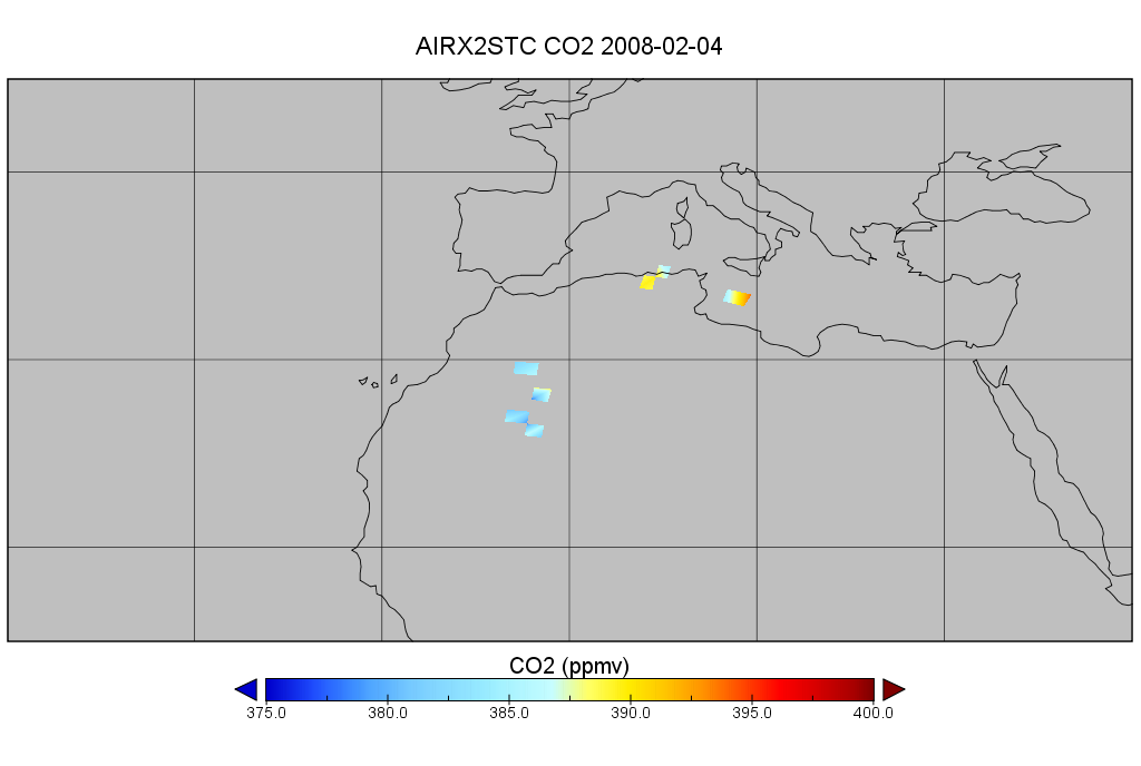
AIRS/Aqua L2 CO2 in the free troposphere (AIRS+AMSU) V005 (AIRX2STC) at GES DISC
National Aeronautics and Space Administration —
The Atmospheric Infrared Sounder (AIRS) is a grating spectrometer (R = 1200) aboard the second Earth Observing System (EOS) polar-orbiting platform, EOS Aqua. In... -
Federal
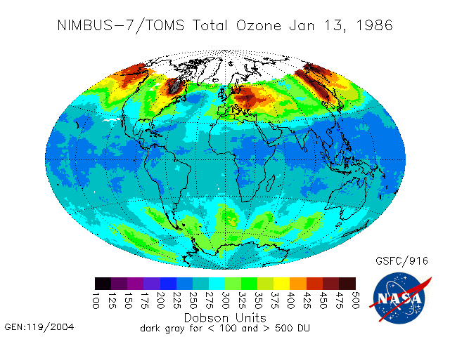
TOMS Nimbus-7 Total Column Ozone Daily L3 Global 1 deg x 1.25 deg Lat/Lon Grid V008 (TOMSN7L3dtoz) at GES DISC
National Aeronautics and Space Administration —
This Nimbus-7 Total Ozone Mapping Spectrometer (TOMS) version 8 daily global gridded data product contains total column ozone values. The data are mapped to a global... -
Federal
LBA-ECO ND-02 Soil Volumetric Water Content, Tapajos National Forest, Brazil
National Aeronautics and Space Administration —
This data set reports monthly measured soil volumetric water content (VWC) from a rainfall exclusion experiment that was conducted from 1999-2001 at the km 67 Seca... -
Federal
CYGNSS Level 2 Ocean Surface Heat Flux Climate Data Record Version 1.2
National Aeronautics and Space Administration —
This dataset contains the third release, Version 1.2, of the CYGNSS Level 2 Ocean Surface Heat Flux Climate Data Record (CDR), which provides the time-tagged and... -
Federal
LOFAR Radio Catalog of Herschel-ATLAS North Galactic Pole Field
National Aeronautics and Space Administration —
This table contains some of the results of Low-Frequency Array (LOFAR) High-Band Array (HBA) observations of the Herschel-ATLAS North Galactic Pole (NGP) survey area.... -
Federal
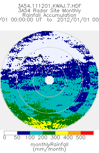
TRMM Ground Validation Radar Site Rain Type Totals Map L3 1 month 2 km V7 (TRMM_3A54) at GES DISC
National Aeronautics and Space Administration —
The 3A54 product, 'Site Rainfall Map', is a map of monthly surface rain totals derived from the instantaneous rain rate maps (2A53). The map is in Cartesian... -
Federal
Global Navigation Satellite System (GNSS) IGS Final Analysis Center (AC) Station Positions/Velocities (no covariance matrix) product from NASA CDDIS - Cloned
National Aeronautics and Space Administration —
This derived product set consists of Global Navigation Satellite System Final Combined Station Positions/Velocities (no covariance matrix) Product available from the... -
Federal
AIRS/Aqua L3 8-day CO2 in the free troposphere (AIRS-only) 2.5 degrees x 2 degrees V005 (AIRS3C28) at GES DISC
National Aeronautics and Space Administration —
The Atmospheric Infrared Sounder (AIRS) is a grating spectrometer (R = 1200) aboard the second Earth Observing System (EOS) polar-orbiting platform, EOS Aqua. In... -
Federal
VIIRS/JPSS1 Land Surface Temperature/Emissivity 8-Day L3 Global 0.05Deg CMG V002
National Aeronautics and Space Administration —
The NOAA-20 Visible Infrared Imaging Radiometer Suite (VIIRS) Land Surface Temperature and Emissivity (LST&E) 8-day Climate Modeling Grid Version 2 product... -
Federal
AMSR-E/AMSR2 Unified L3 Global 5-Day 25 km EASE-Grid Snow Water Equivalent V001
National Aeronautics and Space Administration —
This AMSR-E/AMSR2 Unified Level-3 (L3) data set provides 5-day maximum estimates of Snow Water Equivalent (SWE). SWE was derived from brightness temperature... -
Federal
VIIRS/NPP BRDF/Albedo WSA at Solar Noon Band M7 Daily L3 Global 30ArcSec CMG V002
National Aeronautics and Space Administration —
The NASA/NOAA Suomi National Polar-orbiting Partnership (Suomi NPP) Visible Infrared Imaging Radiometer Suite (VIIRS) Bidirectional Reflectance Distribution Function...

Official websites use .gov
A
.gov website belongs to an official government
organization in the United States.
Secure .gov websites use HTTPS
A
lock (
) or https:// means you’ve safely connected to
the .gov website. Share sensitive information only on official,
secure websites.