
-
Federal
GPM GROUND VALIDATION NASA S-BAND DUAL POLARIMETRIC (NPOL) DOPPLER RADAR IFLOODS
National Aeronautics and Space Administration —
The GPM Ground Validation NASA S-Band Dual Polarimetric (NPOL) Doppler Radar IFloodS dataset was collected from April 30 to June 16, 2013 near Traer, Iowa as part of... -
Federal
VIIRS/NPP BRDF/Albedo WSA at Solar Noon Band M10 Daily L3 Global 30ArcSec CMG V001
National Aeronautics and Space Administration —
The VNP43D74 Version 1 data product was decommissioned on July 31, 2025. Users are encouraged to use theFederalCAMEX-4 TOGA RADAR V1
National Aeronautics and Space Administration —
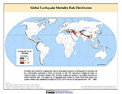
The TOGA radar dataset consists of browse and radar data collected from the TOGA radar during the CAMEX-4 experiment. TOGA is a C-band linear polarized doppler radar...FederalGlobal Earthquake Mortality Risks and Distribution
National Aeronautics and Space Administration —
The Global Earthquake Mortality Risks and Distribution is a 2.5 minute grid of global earthquake mortality risks. Gridded Population of the World, Version 3 (GPWv3)...FederalBARREL 2T X-ray Spectrometer (SSPC) Bremsstrahlung X-ray Spectrum Slow Time Resolution, Level 2, 32 s Data
National Aeronautics and Space Administration —
SSPC: 256 channels of slow time resolution, 32 s, Bremsstrahlung X-ray spectra detected with a NaI Scintillator. The nominal energy range covered by the 256 channels...FederalBOREAS HYD-08 1994 Gravimetric Moss Moisture Data
National Aeronautics and Space Administration —
The BOREAS HYD-08 team made measurements of surface hydrological processes that were collected at the NSA OBS Tower Flux site in 1994 and at Joey Lake, Manitoba, to...FederalMODIS/Terra Thermal Anomalies/Fire 5-Min L2 Swath 1km V061
National Aeronautics and Space Administration —
The Moderate Resolution Imaging Spectroradiometer (MODIS) Thermal Anomalies and Fire MOD14 Version 6.1 product is produced daily in 5-minute temporal satellite...FederalNOAA-20 VIIRS Global Mapped Normalized Difference Vegetation Index Land Reflectance Data, version R2022.0
National Aeronautics and Space Administration —
The Visible and Infrared Imager/Radiometer Suite (VIIRS) is a multi-disciplinary instrument that is being flown on the Joint Polar Satellite System (JPSS) series of...FederalLISTOS Westport Ground Site Data
National Aeronautics and Space Administration —
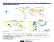
LISTOS_Ground_Westport_Data is the Long Island Sound Tropospheric Ozone Study (LISTOS) Wesport ground site data collected during the LISTOS field campaign. This...FederalGlobal One-Eighth Degree Urban Land Extent Projection and Base Year Grids by SSP Scenarios, 2000-2100
National Aeronautics and Space Administration —
The Global One-Eighth Degree Urban Land Extent Projection and Base Year Grids by SSP Scenarios, 2000-2100 consists of global SSP-consistent spatial urban land...FederalATom: Actinic Flux and Photolysis Frequencies from CAFS Instrument, 2016-2018, V2
National Aeronautics and Space Administration —
This dataset contains actinic flux and photolysis frequencies for photodissociation reactions for a variety of chemical species during the four ATom campaigns....FederalBOREAS Follow-On DSP-10 Reclassified Regridded TM Mosaic Land Cover Maps, 1994
National Aeronautics and Space Administration —
These images were produced by aggregating a reclassified version of the 30-m land cover Thematic Mapper classification by CCRS and are now available at multiple...FederalMODIS/Aqua Land Surface Temperature/Emissivity Monthly L3 Global 0.05Deg CMG V061
National Aeronautics and Space Administration —
The Aqua Moderate Resolution Imaging Spectroradiometer (MODIS) Land Surface Temperature/Emissivity Monthly (MYD11C3) Version 6.1 product provides monthly Land Surface...FederalMeasurement of Air Pollution from Satellites (MAPS) Space Radar Laboratory - 1 (SRL1) Carbon Monoxide Second by Second data
National Aeronautics and Space Administration —
MAPS Overview The MAPS experiment measures the global distribution of carbon monoxide (CO) mixing ratios in the free troposphere. Because of MAPS' previous flights on...FederalGPM GROUND VALIDATION DUAL POLARIZED C-BAND DOPPLER RADAR KING CITY GCPEX
National Aeronautics and Space Administration —
The GPM Ground Validation Dual Polarized C-Band Doppler Radar King City GCPEx dataset has special Range Height Indicator (RHI) and sector scans of several dual...FederalTES/Aura L2 Water Vapor Nadir Special Observation V007
National Aeronautics and Space Administration —
TL2H2ONS_7 is the Tropospheric Emission Spectrometer (TES)/Aura Level 2 Water Vapor Nadir Special Observation Version 7 data product. It consists of information for...FederalWind Weimer Propagated 60 s Resolution Tri-axial Fluxgate Magnetometer in GSM Coordinates
National Aeronautics and Space Administration —
Wind Weimer propagated solar wind data and linearly interpolated to have the measurements on the minute at 60 s resolution tri-axial fluxgate magnetometer data in GSM...FederalMODIS/Terra+Aqua BRDF/Albedo QA ValidobsBand6 Daily L3 Global 30ArcSec CMG V061
National Aeronautics and Space Administration —
The MCD43D38 Version 6.1 Bidirectional Reflectance Distribution Function and Albedo (BRDF/Albedo) QA ValidObs Band 6 dataset is produced daily using 16 days of Terra...12,246 datasets found

Official websites use .gov
A
.gov website belongs to an official government
organization in the United States.
Secure .gov websites use HTTPS
A
lock (
) or https:// means you’ve safely connected to
the .gov website. Share sensitive information only on official,
secure websites.