
-
Federal
S-COSMOS MIPS 160 micron Photometry Catalog
National Aeronautics and Space Administration —
COSMOS is an astronomical survey designed to probe the formation and evolution of galaxies as a function of cosmic time (redshift) and large scale structural... -
Federal
OWLETS-2 Ceilometer Aerosol Data
National Aeronautics and Space Administration —
OWLETS2_Aerosol_Data_1 is the Ozone Water-Land Environmental Transition Study (OWLETS-2) aerosol data collected at various ground sites during the OWLETS-2 field... -
Federal
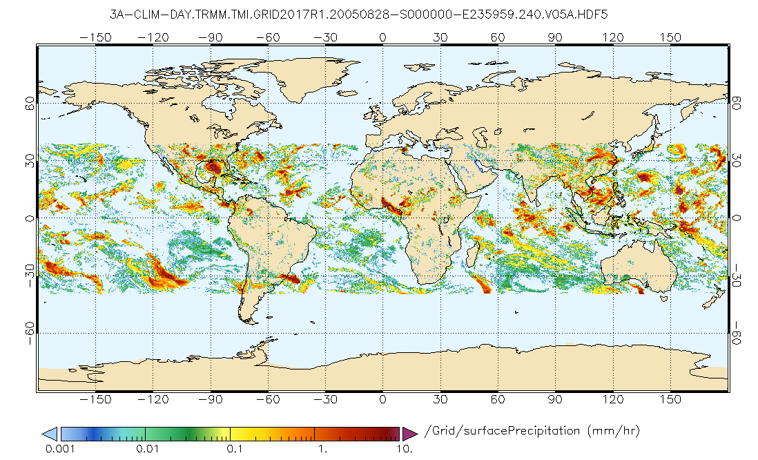
GPM TMI on TRMM (GPROF) Climate-based Radiometer Precipitation Profiling L3 1 day 0.25 degree x 0.25 degree V07 (GPM_3GPROFTRMMTMI_DAY_CLIM) at GES DISC
National Aeronautics and Space Administration —
This a new (GPM-formated) TRMM product. There is no equivalent in the old TRMM suite of products. Version 07 is the current version of the data set. Older versions... -
Federal
ISEE 3 Merged Vector Helium Magnetometer (MAG), and Solar WInd Plasma (SWP), 2 min ASCII Data
National Aeronautics and Space Administration —
ISEE 3 2-m merged magnetic field and plasma data, annual ASCII files, L1 orbit phase 1978-1982 (plasma data only to 1980.02.19) -
Federal
Scanning Multichannel Microwave Radiometer (SMMR) Monthly Mean Atmospheric Liquid Water (ALW) By Prabhakara
National Aeronautics and Space Administration —
SMMR_ALW_PRABHAKARA data are Special Multichannel Microwave Radiometer (SMMR) Monthly Mean Atmospheric Liquid Water (ALW) data by Prabhakara.The Prabhakara Scanning... -
Federal
AMSR-E L2 Rainfall Subset, collocated with CloudSat track V002 (AMSERR_CPR) at GES DISC
National Aeronautics and Space Administration —
This is a subset of AMSR-E rain rate product along CloudSat field of view track. The goal of the subset is to select and return AMSR-E data that are within -100 km... -
Federal
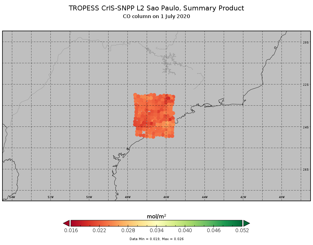
TROPESS CrIS-SNPP L2 for Sao Paulo Megacity, Summary Product V1 (TRPSYL2ALLCRSMGSAO) at GES DISC
National Aeronautics and Space Administration —
The TROPESS CrIS-SNPP L2 for Sao Paulo Megacity, Summary Product contains the vertical distribution of six retrieved atmospheric gases (CH4, CO, HDO, NH3, O3 and... -
Federal
SCR/Nimbus-5 Level 1 Radiance Data from CD-ROM V001 (SCRN5L1RAD_CDROM) at GES DISC
National Aeronautics and Space Administration —
SCRN5L1RAD_CDROM is the gridded Nimbus-5 Selective Chopper Radiometer (SCR) Level 1 Radiance Data Product. The radiances are measured by 16 channels at 2.3 to 15... -
Federal
MASTER: Geological Earth Mapping Experiment (GEMx), Spring 2024
National Aeronautics and Space Administration —
This dataset includes Level 1B (L1B) data products from the MODIS/ASTER Airborne Simulator (MASTER) instrument. The spectral data were collected during 26 flights... -
Federal
COSMOS X-ray Group Catalog - Gozaliasl (2019)
National Aeronautics and Space Administration —
This is the revised catalogue of 247 X-ray groups of galaxies in the 2 square degree COSMOS field with M200c = 8x10^12 - 3x10^14 M_sun at redshift range of 0.08 <=... -
Federal
COSMOS 3GHz AGN Catalog
National Aeronautics and Space Administration —
The VLA-COSMOS 3 GHz AGN catalog includes classification and selected physical properties for the 3 GHz radio sample with optical/NIR counterparts (7 903 sources in... -
Federal
BARREL 4D Data Processing Unit (HKPG) Analog Housekeeping Voltage, Temperature, Current, and Payload Status, Level 2, 40 s Data
National Aeronautics and Space Administration —
Housekeeping voltage, temperature, current, and payload status values returned every 40 s. NOTE: The analog sensor data in these records are based on the nominal... -
Federal
BARREL 3G Ephemeris (EPHM) Geographic and Magnetic Coordinates, Level 2, 4 s Data
National Aeronautics and Space Administration —
Geographic and Magnetic Coordinates: The ephemeris data products, which include the balloon epoch time, latitude, longitude, and altitude, are each returned from the... -
Federal
SBU Mobile Soundings IMPACTS V1
National Aeronautics and Space Administration —
The SBU Mobile Sounding IMPACTS dataset consists of mobile sounding profiles collected during the Investigation of Microphysics and Precipitation for Atlantic Coast-... -
Federal
AMSRIce03 Photomosaics, Version 1
National Aeronautics and Space Administration —
Notice to Data Users: The documentation for this data set was provided solely by the Principal Investigator(s) and was not further developed, thoroughly reviewed, or... -
Federal
VIIRS/NPP BRDF/Albedo WSA at Solar Noon Band M7 Daily L3 Global 30ArcSec CMG V001
National Aeronautics and Space Administration —
The VNP43D72 Version 1 data product was decommissioned on July 31, 2025. Users are encouraged to use theFederalLBA-ECO CD-04 Logging Damage, km 83 Tower Site, Tapajos National Forest, Brazil
National Aeronautics and Space Administration —
This data set contains the results of a survey of logging damage in a 18 ha plot (300 m N-S, 600 m E-W) east (upwind) of the eddy flux tower at km 83, Tapajos...FederalNatural Resource Protection and Child Health Indicators, 2012 Release
National Aeronautics and Space Administration —
The Natural Resource Protection and Child Health Indicators, 2012 Release, are produced in support of the U.S. Millennium Challenge Corporation as selection criteria...FederalSARP 2021 Data
National Aeronautics and Space Administration —
SARP_2021_Data is the data collected onboard the NASA DC-8 aircraft during the 2021 deployment of the Student Airborne Research Program (SARP) mission. Data...FederalSatCORPS CERES GEO Edition 4 Meteosat-09 Southern Hemisphere Version 1
National Aeronautics and Space Administration —
CER_GEO_Ed4_MET09_SH_V01.2 is the Satellite ClOud and Radiation Property retrieval System (SatCORPS) Clouds and the Earth's Radiant Energy System (CERES)...12,246 datasets found

Official websites use .gov
A
.gov website belongs to an official government
organization in the United States.
Secure .gov websites use HTTPS
A
lock (
) or https:// means you’ve safely connected to
the .gov website. Share sensitive information only on official,
secure websites.