
-
Federal
Airborne Multi-angle Imaging SpectroRadiometer (AirMISR) Data from the Monterey 1999 Campaign
National Aeronautics and Space Administration —
The AIRMISR_MONTEREY_1999 data were acquired on June 29, 1999 during a field mission which focused on Monterey, California. The Jet Propulsion Laboratory (JPL) in... -
Federal
MODIS/Aqua Clouds 1km and 5km 5-Min L2 Wide Swath Subset along CloudSat V002 (MAC06S1) at GES DISC
National Aeronautics and Space Administration —
This is the wide-swath MODIS/Aqua subset along CloudSat field of view track. The goal of the wide-swath subset is to select and return MODIS data that are within... -
Federal
SWOT Level 1B Low-Rate Interferogram Data Product, Version D
National Aeronautics and Space Administration —
Interferograms for each of the 9 Doppler beams formed and spatially averaged (low rate) by the On Board Processor, corrected on the ground for phase biases (inherent... -
Federal
LBA-ECO LC-07 Amazon Floodplain Lake Chlorophyll from MODIS, Para, Brazil: 2002-2003
National Aeronautics and Space Administration —
This data set contains chlorophyll concentration maps of the Amazon River floodplain region from Parintins (Amazonas) to Almeirim (Para). These chlorophyll fraction... -
Federal
First ISCCP Regional Experiment (FIRE) Marine Stratocumulus United Kingdom Meteorological Office (UKMO) C-130 Aircraft Data
National Aeronautics and Space Administration —
The First ISCCP Regional Experiments have been designed to improve data products and cloud/radiation parameterizations used in general circulation models (GCMs).... -
Federal
IPCC Special Report on Emissions Scenarios (SRES) 1x1 Degree Gridded Emissions Dataset
National Aeronautics and Space Administration —
The Intergovernmental Panel on Climate Change (IPCC) Special Report on Emissions Scenarios (SRES) 1x1 Degree Gridded Emissions Dataset consists of global gridded... -
Federal
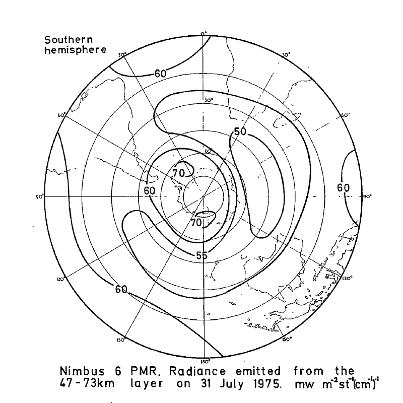
PMR/Nimbus-6 Level 1 Radiance Data from CD-ROM V001 (PMRN6L1RAD_CDROM) at GES DISC
National Aeronautics and Space Administration —
PMRN6L1RAD_CDROM is the gridded Nimbus-6 Pressure Modulated Radiometer (PMR) Level 1 Radiance Data Product. The radiances are measured at CO2 lines in the 15 micron... -
Federal
CYGNSS Level 2 Ocean Surface Heat Flux Climate Data Record Version 1.0
National Aeronautics and Space Administration —
This dataset contains the first release, Version 1.0, of the CYGNSS Level 2 Ocean Surface Heat Flux Climate Data Record (CDR), which provides the time-tagged and... -
Federal
AERONET-OCEAN COLOR
National Aeronautics and Space Administration —
The Aerosol Robotic Network (AERONET), developed to sustain atmospheric studies at various scales with measurements from worldwide distributed autonomous sun-... -
Federal
PnET-BGC: Modeling Biogeochemical Processes in a Northern Hardwood Forest Ecosystem
National Aeronautics and Space Administration —
This archived model product contains the directions, executables, and procedures for running PnET-BGC to recreate the results of Gbondo-Tugbawa, S.S., C.T. Driscoll ,... -
Federal
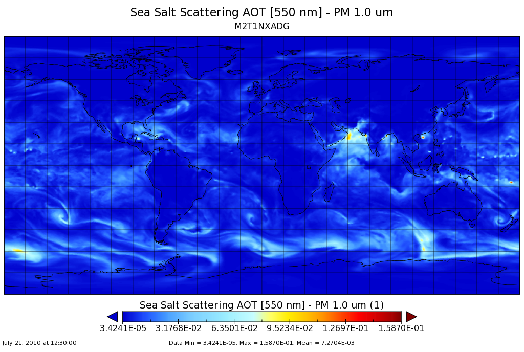
MERRA-2 tavg1_2d_adg_Nx: 2d,1-Hourly,Time-averaged,Single-Level,Assimilation,Aerosol Diagnostics (extended) 0.625 x 0.5 degree V5.12.4 (M2T1NXADG) at GES DISC
National Aeronautics and Space Administration —
M2T1NXADG (or tavg1_2d_adg_Nx) is an hourly time-averaged 2-dimensional data collection in Modern-Era Retrospective analysis for Research and Applications version 2... -
Federal
MLS/Aura (pre-average radiances) Level 3 Hydroperoxy Radical (HO2) Daily 10deg Lat Zonal Mean V005 (ML3DZMHO2) at GES DISC
National Aeronautics and Space Administration —
ML3DZMHO2 is the EOS Aura Microwave Limb Sounder (MLS) daily zonal mean product for hydroperoxy derived from radiances measured in two bands from the 640 GHz... -
Federal
BOREAS TE-12 Leaf Optical Data for SSA Species
National Aeronautics and Space Administration —
The BOREAS TE-12 team collected several data sets in support of its efforts to characterize and interpret information on the reflectance, transmittance, and gas... -
Federal
SWOT Level 2 Radiometer Brightness Temperatures and Troposphere Operational Data Product Version D
National Aeronautics and Space Administration —
The SWOT Level 2 Radiometer Brightness Temperatures and Troposphere Operational Geophysical Data Record (OGDR) Version D dataset produced by the Surface Water and... -
Federal
MERRA-2 inst3_3d_aer_Nv: 3d,3-Hourly,Instantaneous,Model-Level,Assimilation,Aerosol Mixing Ratio 0.625 x 0.5 degree V5.12.4 (M2I3NVAER) at GES DISC
National Aeronautics and Space Administration —
M2I3NVAER (or inst3_3d_aer_Nv) is an instantaneous 3-dimensional 3-hourly data collection in Modern-Era Retrospective analysis for Research and Applications version 2... -
Federal
Arctic Ocean Drift Tracks from Ships, Buoys, and Manned Research Stations, 1872-1973, Version 1
National Aeronautics and Space Administration —
Thirty-four drift tracks in the Arctic Ocean pack ice are collected in a unified tabular data format, one file per track. Data are from drifting ships, manned... -
Federal
GPM ATMS on SUOMI-NPP (GPROF) Radiometer Precipitation Profiling L2 1.5 hours 16 km V07 (GPM_2AGPROFNPPATMS) at GES DISC
National Aeronautics and Space Administration —
Version 07 is the current version of the data set. Older versions will no longer be available and have been superseded by Version 07. The 2AGPROF (Goddard Profiling)... -
Federal
Silalirijiit Project: Kangiqtugaapik (Clyde River), Nunavut, Canada, Weather Station Network, Version 1
National Aeronautics and Space Administration —
The Kangiqtugaapik (Clyde River), Nunavut, Canada, Weather Station Network is a collection of weather station data from the locations of Akuliaqattak, Silasiutitalik,... -
Federal
ABoVE: Synthesis of Burned and Unburned Forest Site Data, AK and Canada, 1983-2016
National Aeronautics and Space Administration —
This dataset is a synthesis of field plot characterization data, derived above-ground and below-ground combusted carbon, and acquired Fire Weather Index (FWI) System... -
Federal
CARVE-ARCSS: Methane Loss From Arctic- Fluxes From the Alaskan North Slope, 2012-2014
National Aeronautics and Space Administration —
This data set provides the results of (1) year-round measurements of methane (CH4) flux along with soil and air temperatures at five eddy covariance towers at sites...

Official websites use .gov
A
.gov website belongs to an official government
organization in the United States.
Secure .gov websites use HTTPS
A
lock (
) or https:// means you’ve safely connected to
the .gov website. Share sensitive information only on official,
secure websites.