
-
Federal
AIRS/Aqua L1B Near Real Time (NRT) Visible/Near Infrared (VIS/NIR) quality assurance subset V005 (AIRVBQAP_NRT) at GES DISC
National Aeronautics and Space Administration —
The AIRS Level 1B Near Real Time (NRT) product (AIRVBQAP_NRT_005) differs from the routine product (AIRVBQAP_005) in 2 ways to meet the three hour latency... -
Federal
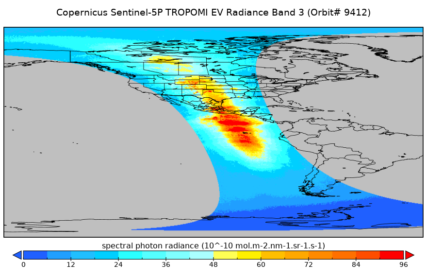
Sentinel-5P TROPOMI Near-Real-Time (NRT) Radiance product band 3 (UVIS detector) L1B 5.5km x 3.5km V2 (S5P_L1B_RA_BD3_HiR_NRT) at GES DISC
National Aeronautics and Space Administration —
The Sentinel-5P TROPOMI Near Real Time (NRT) Radiance product band 3 (UVIS detector) L1B 5.5km x 21km V2 (S5P_L1B_RA_BD3_HiR_NRT_NRT) product at GES DISC is the near... -
Federal
CODATA Catalog of Roads Data Sets, Version 1
National Aeronautics and Space Administration —
The CODATA Catalog of Roads Data Sets, Version 1 contains 367 entries describing national-level road network data sets for 147 countries and four entries describing... -
Federal
GHRSST NOAA/STAR Metop-B AVHRR FRAC ACSPO v2.80 1km L2P Dataset (GDS v2)
National Aeronautics and Space Administration —
The MetOp First Generation (FG) is a European multi-satellite program jointly established by ESA and EUMETSAT, comprising three satellites, MetOp-A, -B and -C. The... -
Federal
Suomi-NPP VIIRS Global Mapped Normalized Difference Vegetation Index Land Reflectance Data, version R2022.0
National Aeronautics and Space Administration —
The Visible and Infrared Imager/Radiometer Suite (VIIRS) is a multi-disciplinary instrument that is being flown on the Joint Polar Satellite System (JPSS) series of... -
Federal
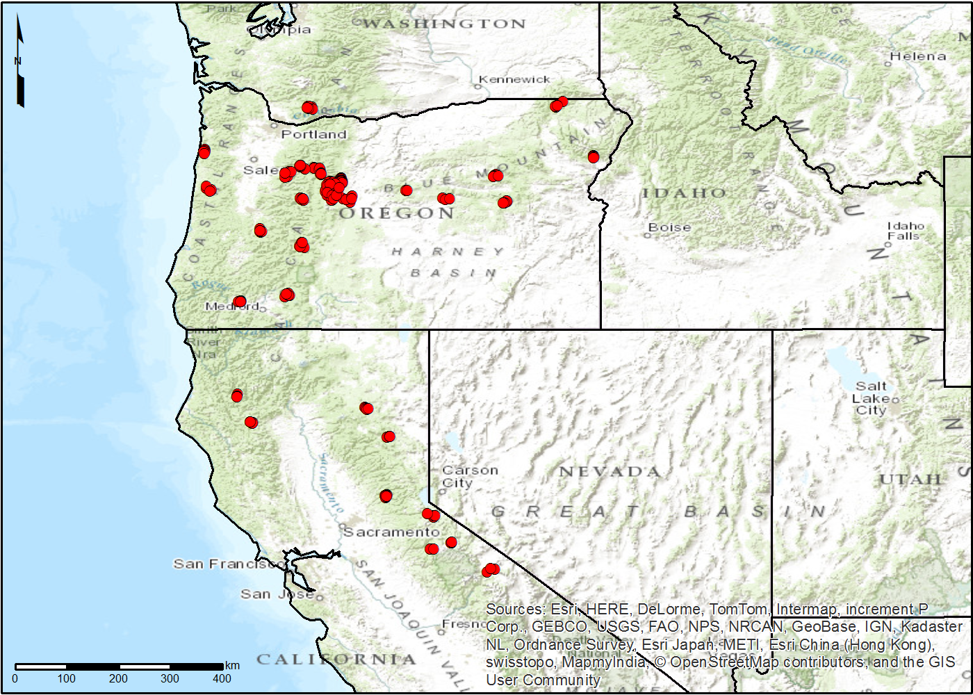
UAlbany Micro Rain Radar 2 (MRR-2) IMPACTS
National Aeronautics and Space Administration —
The UAlbany Micro Rain Radar 2 (MRR-2) IMPACTS dataset consists of reflectivity, Doppler velocity, signal-to-noise ratio, spectral width, droplet size, Liquid Water... -
Federal
XMM-Newton Medium Deep Survey/VIRMOS VLT Deep Survey 4-Sigma Catalog
National Aeronautics and Space Administration —
The XMM-Newton Medium Deep Survey/VIRMOS VLT Deep Survey (XMDS/VVDS) 4-Sigma Catalog contains 286 X-ray sources with their optical identification taken from the XMDS... -
Federal
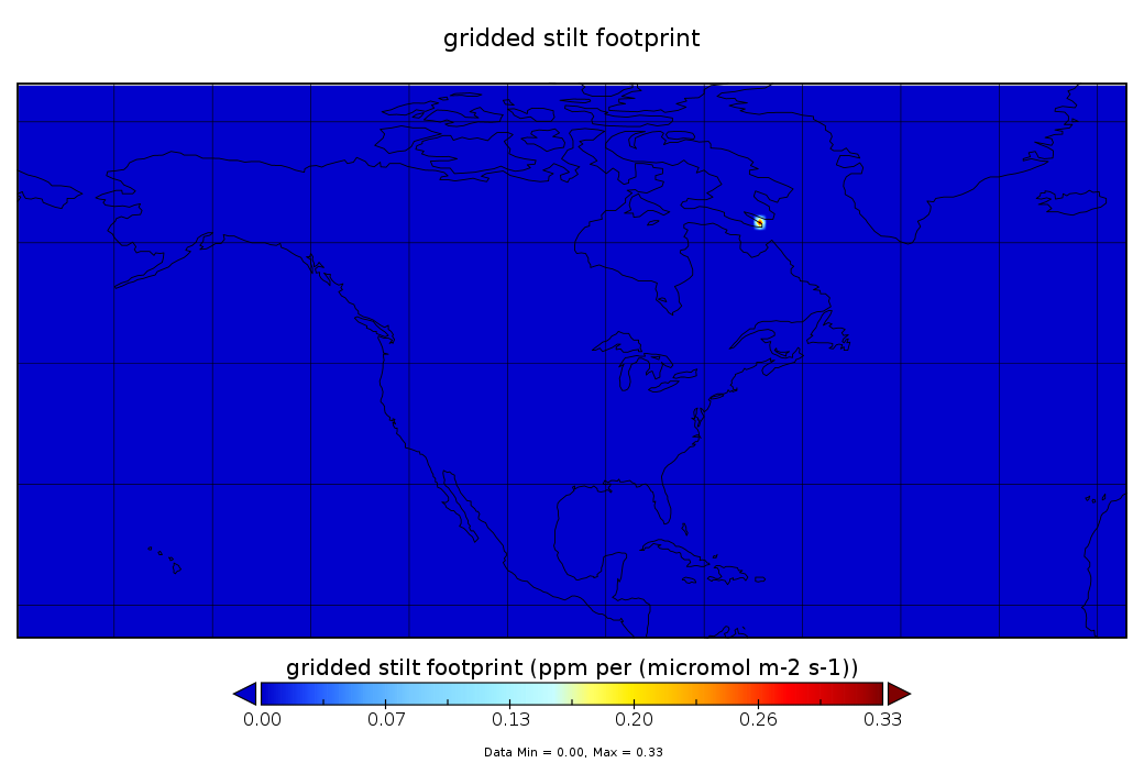
CarbonTracker-Lagrange North America OCO-2 Vertical Profile of Footprints V1 (CMS_CTL_NA_OCO2_FOOTPRINTS)
National Aeronautics and Space Administration —
This data set provides Weather Research and Forecasting (WRF) Stochastic Time-Inverted Lagrangian Transport (STILT) particle trajectory data products for particle... -
Federal
Transcriptional analysis of spleens from mice preserved with the Rapid Freeze hardware
National Aeronautics and Space Administration —
Data from the NASA Rodent Research-1 (RR-1) mission showed that gene-expression levels in mouse livers are different depending on what tissue preservation protocol is... -
Federal
TROPESS CrIS-JPSS1 L2 Carbon Monoxide for Forward Stream, Standard Product V1 (TRPSDL2COCRS1FS) at GES DISC
National Aeronautics and Space Administration —
The TROPESS CrIS-JPSS1 L2 Carbon Monoxide for Forward Stream, Standard Product contains the vertical distribution of the retrieved atmospheric state of carbon... -
Federal
BOREAS TGB-03 Plant Species Composition Data over the NSA Fen
National Aeronautics and Space Administration —
The BOREAS TGB-03 team collected several data sets that contributed to understanding the measured trace gas fluxes over sites in the NSA. This data set contains... -
Federal
CARVE: L2 Atmospheric CO2, CO and CH4 Concentrations, NOAA CRDS, Alaska, 2012-2015
National Aeronautics and Space Administration —
This data set provides atmospheric carbon dioxide (CO2), methane (CH4), carbon monoxide (CO), and water vapor (H2O) concentrations from airborne campaigns over the... -
Federal
S-MODE Saildrone Level 1 Observations
National Aeronautics and Space Administration —
This dataset contains a suite of Saildrone in-situ measurements (including but not limited to temperature, salinity, currents, biochemistry, and meteorology) taken... -
Federal
2008 Environmental Performance Index (EPI)
National Aeronautics and Space Administration —
The 2008 Environmental Performance Index (EPI) centers on two broad environmental protection objectives: (1) reducing environmental stresses on human health, and (2)... -
Federal
VIIRS/NPP BRDF/Albedo WSA at Solar Noon Band M2 Daily L3 Global 30ArcSec CMG V002
National Aeronautics and Space Administration —
The NASA/NOAA Suomi National Polar-orbiting Partnership (Suomi NPP) Visible Infrared Imaging Radiometer Suite (VIIRS) Bidirectional Reflectance Distribution Function... -
Federal
NACP TERRA-PNW: Forest Plant Traits, NPP, Biomass, and Soil Properties, 1999-2014
National Aeronautics and Space Administration —
This data set contains measurements and estimates of leaf, tree, and soil data from six projects conducted by the Terrestrial Ecosystem Research and Regional... -
Federal
LISTOS Bayonne Ground Site Data
National Aeronautics and Space Administration —
LISTOS_Ground_Bayonne_Data is the Long Island Sound Tropospheric Ozone Study (LISTOS) ground site data collected at the Bayonne ground site during the LISTOS field... -
Federal
TES/Aura L2 Summary Profiles Special Observation V008
National Aeronautics and Space Administration —
TL2SUMS_8 is the Tropospheric Emission Spectrometer (TES)/Aura Level 2 Atmospheric Temperatures Limb Version 8 data product. TES was an instrument aboard NASA's Aura... -
Federal
SatCORPS CERES GEO Edition 4 Meteosat-5 Full Disk Version 2
National Aeronautics and Space Administration —
CER_GEO_Ed4_MET05_FD_V02 is the Satellite Cloud and Radiation Property retrieval System (SatCORPS) Clouds and the Earth's Radiant Energy System (CERES) Geostationary...

Official websites use .gov
A
.gov website belongs to an official government
organization in the United States.
Secure .gov websites use HTTPS
A
lock (
) or https:// means you’ve safely connected to
the .gov website. Share sensitive information only on official,
secure websites.