
-
Federal
ECCO Ocean Three-Dimensional Potential Temperature Fluxes - Monthly Mean llc90 Grid (Version 4 Release 4)
National Aeronautics and Space Administration —
This dataset provides monthly-averaged ocean three-dimensional potential temperature fluxes on the native Lat-Lon-Cap 90 (LLC90) model grid from the ECCO Version 4... -
Federal
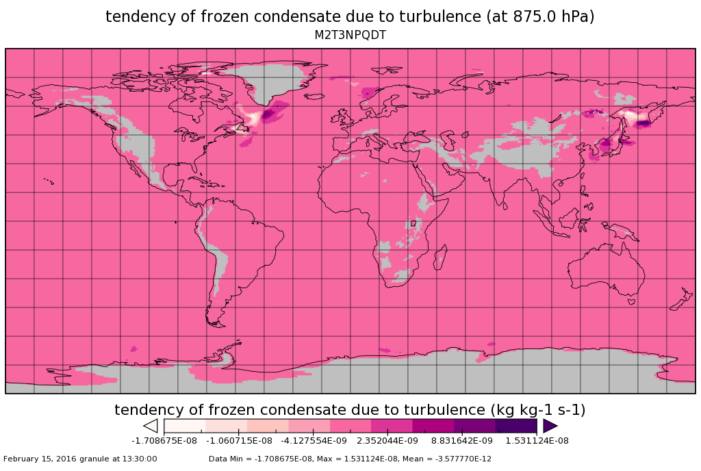
MERRA-2 tavg3_3d_qdt_Np: 3d,3-Hourly,Time-Averaged,Pressure-Level,Assimilation,Moist Tendencies 0.625 x 0.5 degree V5.12.4 (M2T3NPQDT) at GES DISC
National Aeronautics and Space Administration —
M2T3NPQDT (or tavg3_3d_qdt_Np) is a 3-dimensional 3-hourly time averaged data collection in Modern-Era Retrospective analysis for Research and Applications version 2... -
Federal
VIIRS/NPP BRDF/Albedo WSA at Solar Noon Band M4 Daily L3 Global 30ArcSec CMG V002
National Aeronautics and Space Administration —
The NASA/NOAA Suomi National Polar-orbiting Partnership (Suomi NPP) Visible Infrared Imaging Radiometer Suite (VIIRS) Bidirectional Reflectance Distribution Function... -
Federal
Suomi-NPP VIIRS Global Mapped Chlorophyll (CHL) - NRT Data, version R2022.0
National Aeronautics and Space Administration —
The Ocean Biology DAAC produces near real-time (quicklook) products using the best-available combination of ancillary data from meteorological and ozone data. As... -
Federal
KDTX NEXRAD IMPACTS V1
National Aeronautics and Space Administration —
The KDTX NEXRAD IMPACTS dataset consists of Next Generation Weather Radar (NEXRAD) Level II surveillance data that were collected at 31 NEXRAD sites from January 1 to... -
Federal
Global Land Ice Velocity Extraction from Landsat 8 (GoLIVE), Version 1
National Aeronautics and Space Administration —
This data set is a compilation of ice velocity mappings generated from pairs of Landsat 8 panchromatic images acquired from May 2013 to present covering all... -
Federal
High Mountain Asia LDAS 1 km Snow and Temperature Parameters V001
National Aeronautics and Space Administration —
This data set provides daily-averaged NASA Land Information System (LIS) output at a spatial resolution of 1 km. LIS was driven by uncorrected Modern-Era... -
Federal
TES/Aura L2 Carbon Dioxide Nadir Special Observation V007
National Aeronautics and Space Administration —
TL2CO2NS_7 is the Tropospheric Emission Spectrometer (TES)/Aura Level 2 Carbon Dioxide Nadir Special Observation Version 7 data product. TES Level 2 data contain... -
Federal
30 Doradus Catalog ConeSearch
National Aeronautics and Space Administration —
30 Doradus (a.k.a. the Tarantula Nebula), with its ionizing cluster R136, is one of the few known starbursts in the Local Group. For size (~200 pc in diameter) and... -
Federal
OrbView-2 SeaWiFS Global Mapped Inherent Optical Properties (IOP) Data, version R2022.0
National Aeronautics and Space Administration —
The SeaWiFS instrument was launched by Orbital Sciences Corporation on the OrbView-2 (a.k.a. SeaStar) satellite in August 1997, and collected data from September 1997... -
Federal
ACCLIP WB-57 Meteorological and Navigational Data
National Aeronautics and Space Administration —
ACCLIP_MetNav_AircraftInSitu_WB57_Data is the in-situ meteorology and navigational data collection during the Asian Summer Monsoon Chemical & Climate Impact... -
Federal
BARREL 2K X-ray Spectrometer (MSPC) Bremsstrahlung X-ray Spectrum Medium Time Resolution, Level 2, 4 s Data
National Aeronautics and Space Administration —
MSPC: 48 channels of medium time resolution, 4 s, Bremsstrahlung X-ray spectra detected with a NaI Scintillator. The nominal energy range covered by the 48 channels... -
Federal
Wind 3DP Linearly Interpolated 60 s Resolution data in GSE Coordinates
National Aeronautics and Space Administration —
Wind linearly interpolated to have the measurements on the minute at 60 s resolution 3DP data in GSE coordinates. This data set consists of processed solar wind data... -
Federal
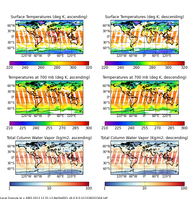
AIRS/Aqua L3 Daily Standard Physical Retrieval (AIRS+AMSU) 1 degree x 1 degree V006 (AIRX3STD) at GES DISC
National Aeronautics and Space Administration —
The Atmospheric Infrared Sounder (AIRS) is a grating spectrometer (R = 1200) aboard the second Earth Observing System (EOS) polar-orbiting platform, EOS Aqua. In... -
Federal
INTEX-A DC-8 Aircraft Trajectory data
National Aeronautics and Space Administration —
Intercontinental Chemical Transport Experiment - North America Phase A (INTEX-A) is an integrated atmospheric field experiment performed over North America. The study... -
Federal
Helioviewer API
National Aeronautics and Space Administration —
The Helioviewer Project maintains a set of Public APIs with the goal of improving access to solar and heliospheric datasets to scientists, educators, developers, and... -
Federal
Gridded Species Distribution: Global Amphibian Richness Grids, 2015 Release
National Aeronautics and Space Administration —
The 2015 Release of the Global Amphibian Richness Grids data set of the Gridded Species Distribution collection are aggregations of the presence grids data for the... -
Federal
BARREL 2P X-ray Spectrometer (FSPC) Bremsstrahlung X-ray Spectrum Fast Time Resolution, Level 2, 0.05 s Data
National Aeronautics and Space Administration —
FSPC: Six channels of fast time resolution, 50 ms, Bremsstrahlung X-ray spectra detected with a NaI Scintillator. Each channel is separated in its own variable:... -
Federal
TRACE-A DC-8 In-Situ Trace Gas Data
National Aeronautics and Space Administration —
TRACE-A_TraceGas_AircraftInSitu_DC8_Data is the in-situ trace gas data collected onboard the DC-8 aircraft during the Transport and Atmospheric Chemistry near the...

Official websites use .gov
A
.gov website belongs to an official government
organization in the United States.
Secure .gov websites use HTTPS
A
lock (
) or https:// means you’ve safely connected to
the .gov website. Share sensitive information only on official,
secure websites.