
-
Federal
NGC 2903 Central Region Chandra X-Ray Point Source Catalog
National Aeronautics and Space Administration —
This table contains some of the results from a deep Chandra observation of the central regions of the late-type barred spiral galaxy NGC 2903. The Chandra data reveal... -
Federal
Unified Sea Ice Thickness Climate Data Record, 1947 Onward, Version 1
National Aeronautics and Space Administration —
The Unified Sea Ice Thickness Climate Data Record, 1947 Onward is the result of a concerted effort to collect as many observations as possible of Arctic and Antarctic... -
Federal
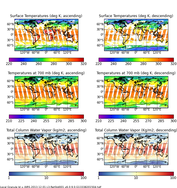
AIRS/Aqua L3 Daily Support Product (AIRS+AMSU) 1 degree x 1 degree V006 (AIRX3SPD) at GES DISC
National Aeronautics and Space Administration —
The Atmospheric Infrared Sounder (AIRS) is a grating spectrometer (R = 1200) aboard the second Earth Observing System (EOS) polar-orbiting platform, EOS Aqua. In... -
Federal
TRACE-P DC-8 Remotely Sensed Differential Absorption Lidar (DIAL) Data
National Aeronautics and Space Administration —
TRACE-P_AircraftRemoteSensing_DC8_DIAL_Data is the remotely sensed Differential Absorption Lidar (DIAL) data collected onboard the DC-8 aircraft during the Transport... -
Federal
Aqua MODIS Level-1 Data NGDA
National Aeronautics and Space Administration —
MODIS (or Moderate Resolution Imaging Spectroradiometer) is a key instrument aboard the Terra (EOS AM) and Aqua (EOS PM) satellites. Terra's orbit around the Earth is... -
Federal
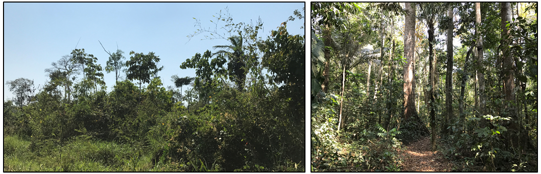
Forest Inventories and DBH at Burned and Unburned Forest Sites, Acre, Brazil, 2017
National Aeronautics and Space Administration —
This data set provides measurements of diameter at breast height (DBH) and species identification at four forest sites in the eastern side of Acre, Brazil including... -
Federal
Maps of Vegetation, NDVI, Snow and Thaw Depths: North Slope, Alaska and NWT, Canada
National Aeronautics and Space Administration —
This dataset includes vegetation cover maps, Normalized Difference Vegetation Index (NDVI) maps, snow depth and thaw depth data that were obtained as part of a... -
Federal
VIIRS/SNPP Deep Blue Aerosol L2 6-Min Swath 6 km
National Aeronautics and Space Administration —
The Suomi National Polar-orbiting Partnership (SNPP) Visible Infrared Imaging Radiometer Suite (VIIRS) NASA standard Level-2 (L2) deep blue aerosol product provides... -
Federal
SAFARI 2000 MISR Level 2 Data, Southern Africa, Dry Season 2000
National Aeronautics and Space Administration —
MISR (Multi-angle Imaging SpectroRadiometer) views the sunlit Earth simultaneously at nine widely spaced and collects global images with high spatial detail in four... -
Federal
Aqua AIRS-MODIS 1-km Matchup Indexes V1 (Aqua_AIRS_MODIS1km_IND) at GES_DISC
National Aeronautics and Space Administration —
This dataset includes Aqua AIRS to MODIS 1-km collocation index product, within the framework of the Multidecadal Satellite Record of Water Vapor, Temperature, and... -
Federal
CDDIS_VLBI_data
National Aeronautics and Space Administration —
Very Long Baseline Interferometry (VLBI) is a geometric technique: it measures the time difference between the arrival at two Earth-based antennas of a radio... -
Federal
VIIRS/JPSS1 BRDF/Albedo BSA at Solar Noon Band M1 Daily L3 Global 30ArcSec CMG V002
National Aeronautics and Space Administration —
The NOAA-20 Visible Infrared Imaging Radiometer Suite (VIIRS) Bidirectional Reflectance Distribution Function (BRDF) and Albedo Black-Sky Albedo for Band M1... -
Federal
Global Navigation Satellite System (GNSS) IGS Final Cumulative Station Positions/Velocities Product from NASA CDDIS
National Aeronautics and Space Administration —
This derived product set consists of Global Navigation Satellite System Final Combined Station Positions/Velocities Product available from the Crustal Dynamics Data... -
Federal
CLPX-Satellite: AMSR-E Brightness Temperature Grids, Version 1
National Aeronautics and Space Administration —
This data set includes Aqua Advanced Microwave Scanning Radiometer - Earth Observing System (AMSR-E) passive microwave brightness temperatures gridded to the... -
Federal
SMAPVEX12 In Situ Vegetation Data for Agricultural Area V001
National Aeronautics and Space Administration —
This data set contains in situ vegetation data collected at several agricultural sites as a part of the Soil Moisture Active Passive Validation Experiment 2012... -
Federal
IMP 7 LANL 2-m plasma data
National Aeronautics and Space Administration —
IMP 7 LANL 2-min solar wind plasma parameter data, including temperature anisotropy and alpha/proton ratio -
Federal
Advanced Scatterometer (ASCAT) CPEX V1
National Aeronautics and Space Administration —
The Advanced Scatterometer (ASCAT) CPEX dataset consists of ice probability, wind speed, and wind direction estimates collected by the ASCAT. The ASCAT is onboard the... -
Federal
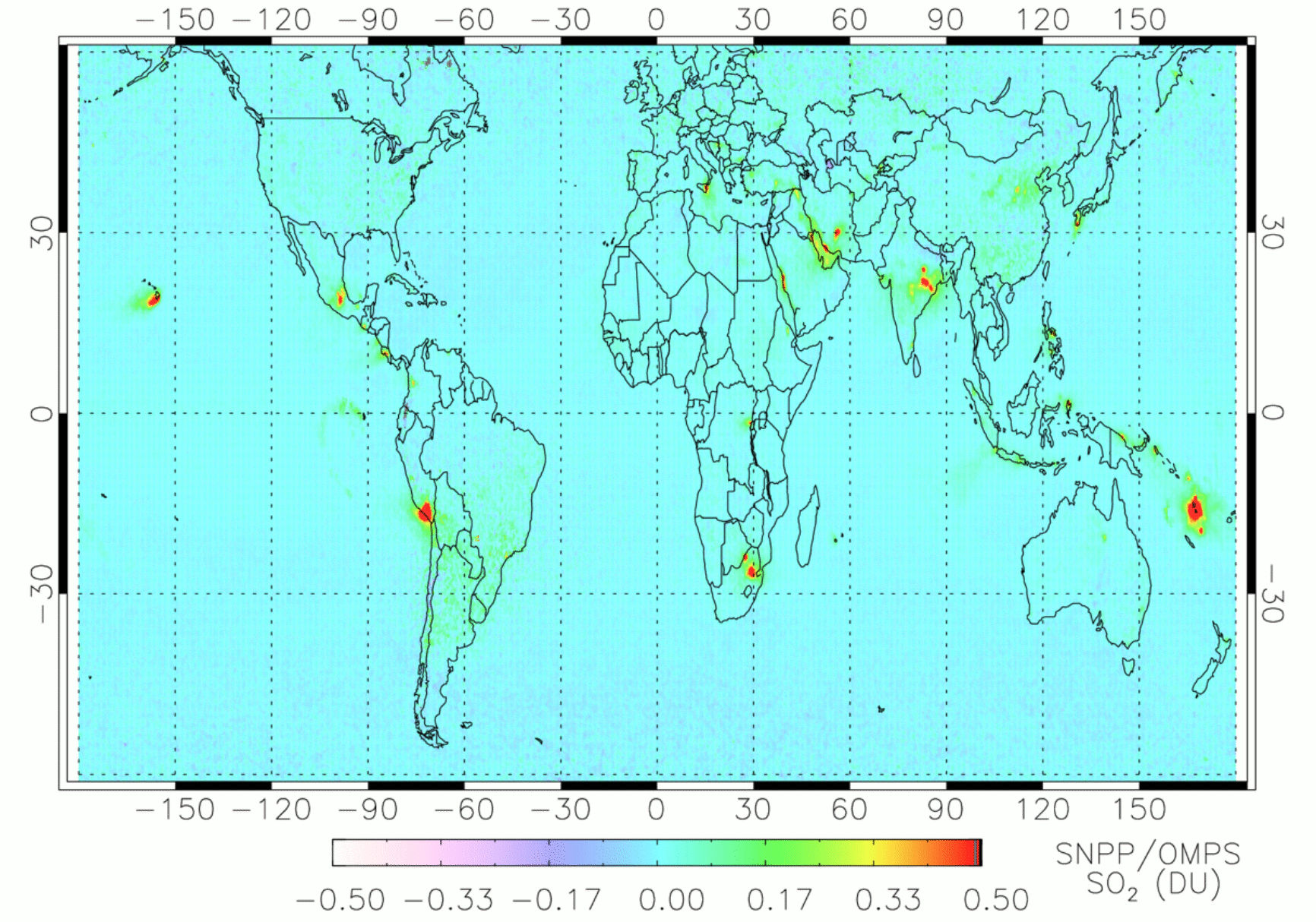
OMPS/NPP PCA SO2 Total Column 1-Orbit L2 Swath 50x50km V2 (OMPS_NPP_NMSO2_PCA_L2) at GES DISC
National Aeronautics and Space Administration —
The OMPS_NPP_NMSO2_PCA_L2 product is part of the MEaSUREs (Making Earth Science Data Records for Use in Research Environments) suite of products. It is retrieved from... -
Federal
TRACE-P P-3B In-Situ Trace Gas Data
National Aeronautics and Space Administration —
TRACE-P_TraceGas_AircraftInSitu_P3B_Data is the in-situ trace gas data collected onboard the P-3B aircraft during the Transport and Chemical Evolution over the... -
12,246 datasets found

Official websites use .gov
A
.gov website belongs to an official government
organization in the United States.
Secure .gov websites use HTTPS
A
lock (
) or https:// means you’ve safely connected to
the .gov website. Share sensitive information only on official,
secure websites.