
-
Federal
Goddard Satellite-Based Surface Turbulent Fluxes, 1x1 deg Yearly Climatology, Set1 and NCEP V2c (GSSTFYC) at GES DISC
National Aeronautics and Space Administration —
These data are the Goddard Satellite-based Surface Turbulent Fluxes Version-2c Dataset recently produced through a MEaSURES funded project led by Dr. Chung-Lin Shie... -
Federal
First ISCCP Regional Experiment (FIRE) Extensive Time Observations (ETO) University of Utah Polar Diversification LIDAR
National Aeronautics and Space Administration —
The First ISCCP Regional Experiments have been designed to improve data products and cloud/radiation parameterizations used in general circulation models (GCMs).... -
Federal
HIRDLS/Aura Level 3 Geopotential Height 1deg Lat Zonal Fourier Coefficients V007 (H3ZFCGPH) at GES DISC
National Aeronautics and Space Administration —
The "HIRDLS/Aura Level 3 Geopotential Height Zonal Fourier Coefficients" version 7 data product (H3ZFCGPH) contains the entire mission (~3 years) of HIRDLS data... -
Federal
ACTIVATE King Air Aerosol and Cloud Remotely Sensed Data
National Aeronautics and Space Administration —
ACTIVATE_AerosolCloud_AircraftRemoteSensing_KingAir_Data is the aerosol and cloud data collected onboard the B-200 King Air aircraft via remote sensing... -
Federal
PSRPI Mapping the Galactic distribution of pulsars with the VLBA
National Aeronautics and Space Administration —
Observations for the initial PSRPI sample of 60 pulsars have now concluded. 84.7 hours were observed on the VLBA (plus 12 hours from a pilot project) searching for... -
Federal
ISIS 1 Topside Sounder Ionograms
National Aeronautics and Space Administration —
These ionograms were digitized from the original ISIS-1 7-track analog telemetry tapes using the facilities of the former Data Evaluation Laboratory at the NASA/GSFC.... -
Federal
OMI/Aura TOMS-Like Ozone, Aerosol Index, Cloud Radiance Fraction L3 1 day 1 degree x 1 degree V004 (OMTO3d) at GES DISC
National Aeronautics and Space Administration —
The OMI science team produces this Level-3 daily global TOMS-Like Total Column Ozone gridded product OMTO3d (1 deg Lat/Lon grids). The OMTO3d product is produced by... -
Federal
Suomi-NPP VIIRS Global Mapped Particulate Inorganic Carbon (PIC) - Near Real Time (NRT) Data, version R2022.0
National Aeronautics and Space Administration —
The Ocean Biology DAAC produces near real-time (quicklook) products using the best-available combination of ancillary data from meteorological and ozone data. As... -
Federal
IMP 6 LANL 2-m plasma data
National Aeronautics and Space Administration —
IMP 6 LANL 2-min solar wind plasma parameter data, including temperature anisotropy and alpha/proton ratio -
Federal
CGRO BATSE-Observed Piccinotti Sample of Active Galactic Nuclei
National Aeronautics and Space Administration —
Compton Gamma-Ray Observatory (CGRO) BATSE Earth-occultation data have been used by Malizia et al. (1999, ApJ, 519, 637) to search for emission in the 20-100 keV band... -
Federal
BOREAS TGB-12 Soil Carbon Data: NSA
National Aeronautics and Space Administration —
The BOREAS TGB-12 team made measurements of soil carbon inventories, carbon concentration in soil gases, and rates of soil respiration at several sites to estimate... -
Federal
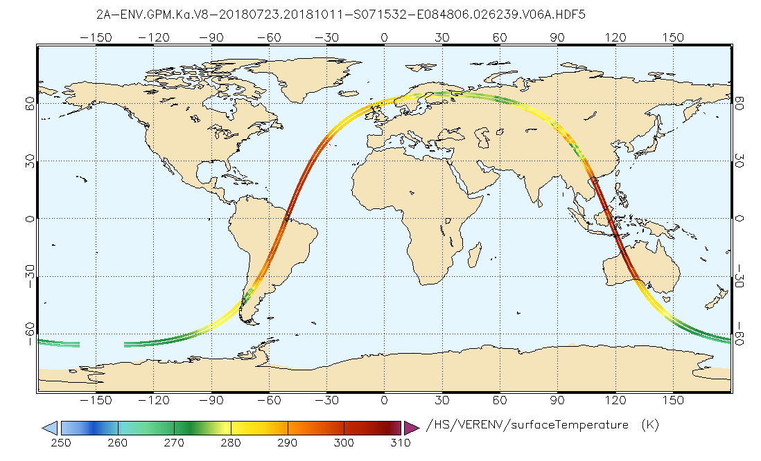
GPM DPR Ka Environment L2A 1.5 hours 5 km V07 (GPM_2AKaENV) at GES DISC
National Aeronautics and Space Administration —
Version 07 is the current version of the data set. Older versions will no longer be available and have been superseded by Version 07. . This is environmental data... -
Federal
SARP 2011 Data
National Aeronautics and Space Administration —
SARP_2011_Data is the data collected onboard the NASA DC-8 aircraft during the 2011 deployment of the Student Airborne Research Program (SARP) mission. Data... -
Federal
MODIS/Aqua Aerosol Cloud Water Vapor Ozone Monthly L3 Global 1Deg CMG
National Aeronautics and Space Administration —
The MODIS/Aqua Aerosol Cloud Water Vapor Ozone Monthly L3 Global 1Deg CMG product (MYD08_M3) contains monthly 1 x 1 degree grid average values of atmospheric... -
Federal
SMAPVEX12 PALS Backscatter Data V001
National Aeronautics and Space Administration —
This data set contains backscatter data obtained by the Passive Active L-band System (PALS) microwave aircraft instrument as part of the Soil Moisture Active Passive... -
Federal
ROSETTA-ORBITER PRELANDING OSINAC 3 RDR MTP007 V2.0
National Aeronautics and Space Administration —
This data set contains images acquired by the OSIRIS Narrow Angle Camera during the PRELANDING phase of the Rosetta mission at the comet 67P, covering the period from... -
Federal
Aeolus CalVal HALO Aerosol and Water Vapor Profiles and Images
National Aeronautics and Space Administration —
Aeolus-CalVal-HALO_DC8_1 is the Aeolus CalVal HALO Aerosol and Water Vapor Profiles and Images data product. Data was collected using the High Altitude Lidar... -
Federal
MODIS/Aqua Land Surface Temperature/3-Band Emissivity Daily L3 Global 1km SIN Grid Day V061
National Aeronautics and Space Administration —
A suite of MODIS Land Surface Temperature and Emissivity (LST&E) products are available in Collection 6.1. The MYD21 LST algorithm differs from the algorithm of... -
Federal
SDO/AIA 171 Angstrom FITS Data
National Aeronautics and Space Administration —
The SDO/AIA 171 Å Level 1 FITS Data .The 171 Å channel observes the Fe ix line from quiet corona and upper transition region (0.63 MK).\n\nThe Atmospheric Imaging... -
Federal
All-Sky Optical Catalog of Radio/X-Ray Sources
National Aeronautics and Space Administration —
The Quasars.org (QORG) Catalog is an all-sky optical catalog of radio/X-ray sources. The QORG Catalog aligns and overlays the year 2001/2 releases of the ROSAT HRI,...

Official websites use .gov
A
.gov website belongs to an official government
organization in the United States.
Secure .gov websites use HTTPS
A
lock (
) or https:// means you’ve safely connected to
the .gov website. Share sensitive information only on official,
secure websites.