
-
Federal
DISCOVER-AQ Maryland Deployment Essex Ground Site Data
National Aeronautics and Space Administration —
DISCOVERAQ_Maryland_Ground_Essex_Data contains data collected at the Essex ground site during the Maryland (Baltimore-Washington) deployment of NASA's DISCOVER-AQ... -
Federal
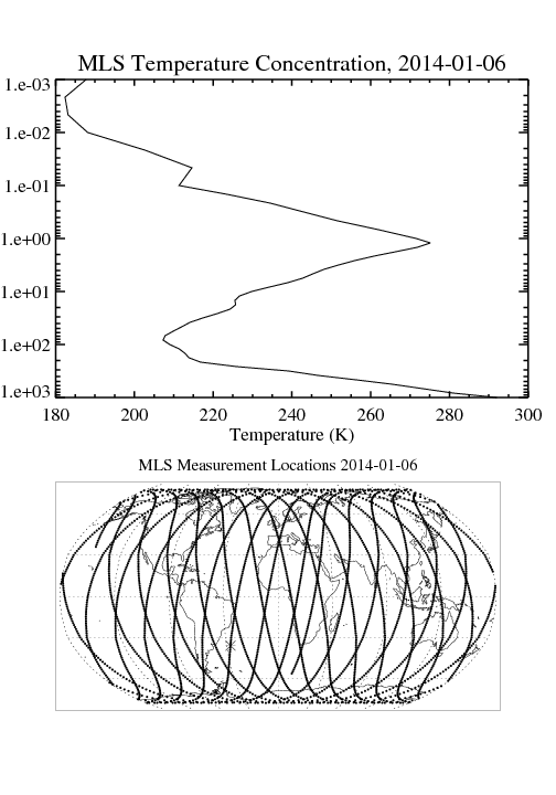
MLS/Aura Level 2 Temperature V004 (ML2T) at GES DISC
National Aeronautics and Space Administration —
ML2T is the EOS Aura Microwave Limb Sounder (MLS) standard product for temperature derived from radiances measured by the 118 and 240 GHz radiometers. The data... -
Federal
CALIPSO Lidar Level 3 Tropospheric Aerosol Profiles, All Sky Data, Standard V4-21
National Aeronautics and Space Administration —
CAL_LID_L3_Tropospheric_APro_AllSky-Standard-V4-21 is the Cloud-Aerosol Lidar and Infrared Pathfinder Satellite Observation (CALIPSO) Lidar Level 3 Tropospheric... -
Federal
BOREAS TE-05 Diurnal CO2 Canopy Profile Data
National Aeronautics and Space Administration —
These data were collected by BOREAS TE-05 to provide detailed information within the canopy during times when TE-05 sampled canopy CO2 for carbon and oxygen isotope... -
Federal
CLPX-Ground: Snow Measurements at the Local Scale Observation Site (LSOS), Version 1
National Aeronautics and Space Administration —
This data set presents snow depth, snow water equivalence (SWE), snow wetness data, and snow pit data from two pine sites and a small clearing at the Local Scale... -
Federal
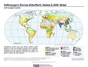
Anthropogenic Biomes of the World, Version 2: 2000
National Aeronautics and Space Administration —
The Anthropogenic Biomes of the World, Version 2: 2000 data set describes anthropogenic transformations within the terrestrial biosphere caused by sustained direct... -
Federal
TROPICS06 Pathfinder L2B Instantaneous Surface Rain Rate (ISRR) V1.0
National Aeronautics and Space Administration —
The "Time-Resolved Observations of Precipitation structure and storm Intensity with a Constellation of Smallsats" (TROPICS) mission has a goal of providing nearly... -
Federal
Atacama Cosmology Telescope DR5 Sunyaev-Zeldovich Cluster Catalog
National Aeronautics and Space Administration —
The catalog of 4195 optically confirmed Sunyaev-Zel'dovich (SZ) selected galaxy clusters were detected with signal-to-noise > 4 in 13,211 deg2 of sky surveyed by... -
Federal
BOREAS/AES MARS-II 15-minute Surface Meteorological Data: 1994
National Aeronautics and Space Administration —
Canadian AES personnel collected several data sets related to surface and atmospheric meteorological conditions over the BOREAS region. This data set contains... -
Federal
SMEX02 Iowa Regional Ground Soil Moisture Data, Version 1
National Aeronautics and Space Administration —
These data were collected as part of a validation study for the Advanced Microwave Scanning Radiometer - Earth Observing System (AMSR-E). Data were collected in crop... -
Federal
NGC 4649 Chandra X-Ray Point Source Catalog 2
National Aeronautics and Space Administration —
This table contains the main X-ray source catalog for the Chandra monitoring observations of the 16.5-Mpc distant elliptical galaxy, NGC 4649. The galaxy has been... -
Federal
Cloud Physics LiDAR (CPL) IMPACTS V1
National Aeronautics and Space Administration —
The Cloud Physics LiDAR (CPL) IMPACTS dataset consists of backscatter coefficient, lidar depolarization ratio, layer top/base height, layer type, particulate... -
Federal
Sounder SIPS: Suomi NPP CrIMSS Level 2 CLIMCAPS Full Spectral Resolution: Atmosphere cloud and surface geophysical state V2 (SNDRSNIML2CCPRET) at GES DISC
National Aeronautics and Space Administration —
WARNING: To users of the derived product “co_mmr_midtrop” (carbon monoxide mass mixing ratio to dry air [kg/kg] at ~500 hPa). This variable has a significant bias due... -
Federal
BARREL 1R X-ray Spectrometer (MSPC) Bremsstrahlung X-ray Spectrum Medium Time Resolution, Level 2, 4 s Data
National Aeronautics and Space Administration —
MSPC: 48 channels of medium time resolution, 4 s, Bremsstrahlung X-ray spectra detected with a NaI Scintillator. The nominal energy range covered by the 48 channels... -
Federal
MLS/Aura Level 3 Daily Binned Geopotential Height (GPH) on Assorted Grids V005 (ML3DBGPH) at GES DISC
National Aeronautics and Space Administration —
ML3DBGPH is the EOS Aura Microwave Limb Sounder (MLS) daily binned on various vertical grids product for geopotential height (GPH) derived from radiances measured by... -
Federal
SOLVE II DC-8 Aircraft In-situ Meteorology and Navigational Data
National Aeronautics and Space Administration —
SOLVE2_MetNav_AircraftInSItu_DC8_Data is the in-situ meteorological and navigational data for the DC-8 aircraft collected during the SAGE III Ozone Loss and... -
Federal
BARREL 1N Ephemeris (EPHM) Geographic and Magnetic Coordinates, Level 2, 4 s Data
National Aeronautics and Space Administration —
Geographic and Magnetic Coordinates: The ephemeris data products, which include the balloon epoch time, latitude, longitude, and altitude, are each returned from the... -
Federal
STAQS JSC GV High Spectral Resolution Lidar-2 Data
National Aeronautics and Space Administration —
STAQS_AircraftRemoteSensing_JSC-GV_HSRL2_Data is the remotely sensed trace gas data for the JSC Gulfstream V aircraft taken by the High Spectral Resolution Lidar-2... -
Federal
TOVS GLA 5 DAY GRIDS from NOAA-10 V01 (TOVSA5NG) at GES DISC
National Aeronautics and Space Administration —
This dataset (TOVSA5NG) contains the TIROS Operational Vertical Sounder (TOVS) level 3 geophysical parameters derived using data from NOAA-10 and the physical...

Official websites use .gov
A
.gov website belongs to an official government
organization in the United States.
Secure .gov websites use HTTPS
A
lock (
) or https:// means you’ve safely connected to
the .gov website. Share sensitive information only on official,
secure websites.