
-
Federal
LANDSAT SURFACE REFLECTANCE -L7 ETM+
National Aeronautics and Space Administration —
Landsat satellite data have been produced, archived, and distributed by the U.S. Geological Survey (USGS) since 1972. Users rely on these data for historical study of... -
Federal
TES/Aura L2 Ammonia Lite Nadir V006
National Aeronautics and Space Administration —
Atmospheric vertical profile estimates and associated errors including the mapping matrix to relate the reduced-size retrieval vectors, covariances, and averaging... -
Federal
Daily 8-Hour Maximum and Annual O3 Concentrations for the Contiguous United States, 1-km Grids, v1 (2000 - 2016)
National Aeronautics and Space Administration —
The Daily 8-Hour Maximum and Annual O3 Concentrations for the Contiguous United States, 1-km Grids, v1 (2000 - 2016) data set contains estimates of ozone... -
Federal
IRIS/Nimbus-4 Level 1 Radiance Data V001 (IRISN4RAD) at GES DISC
National Aeronautics and Space Administration —
The Nimbus-4 Infrared Interferometer Spectrometer (IRIS) Level 1 Radiance Data contain thermal emissions of the Earth's atmosphere at wave numbers between 400 and... -
Federal
Natural Resource Protection and Child Health Indicators, 2023 Release
National Aeronautics and Space Administration —
The Natural Resource Protection and Child Health Indicators, 2023 Release, is produced in support of the U.S. Millennium Challenge Corporation as selection criteria... -
Federal
CDDIS_GNSS_highrate_data
National Aeronautics and Space Administration —
Global Navigation Satellite System (GNSS) data consists of the U.S. Global Positioning System (GPS) and the Russian GLObal NAvigation Satellite System (GLONASS) (plus... -
Federal
OCO-2 Level 2 geolocated XCO2 retrievals results, physical model V11.2 (OCO2_L2_Standard) at GES DISC
National Aeronautics and Space Administration —
Version 11.2 is the current version of the data set. Older versions will no longer be available and are superseded by Version 11.2. The Orbiting Carbon Observatory is... -
Federal
VIIRS/SNPP Deep Blue Aerosol L2 6-Min Swath 6 km (v2.0)
National Aeronautics and Space Administration —
The Suomi National Polar-orbiting Partnership (SNPP) Visible Infrared Imaging Radiometer Suite (VIIRS) NASA standard Level-2 (L2) deep blue aerosol product provides... -
Federal
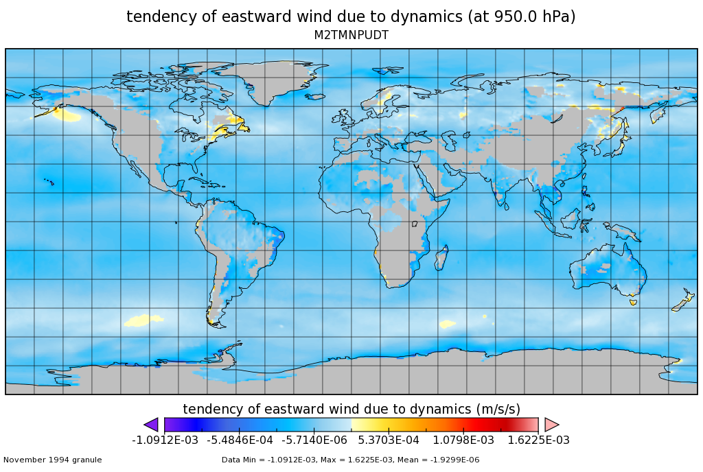
MERRA-2 tavgM_3d_udt_Np: 3d,Monthly mean,Time-Averaged,Pressure-Level,Assimilation,Wind Tendencies 0.625 x 0.5 degree V5.12.4 (M2TMNPUDT) at GES DISC
National Aeronautics and Space Administration —
M2TMNPUDT (or tavgM_3d_udt_Np) is a 3-dimensional monthly mean data collection in Modern-Era Retrospective analysis for Research and Applications version 2 (MERRA-2).... -
Federal
The VIIth Catalog of Galactic Wolf-Rayet Stars
National Aeronautics and Space Administration —
The VIIth Catalogue of Galactic Population I Wolf-Rayet (WR) Stars provides improved coordinates, spectral types, and bv photometry of known WR stars and adds 71 new... -
Federal
MODIS/Terra+Aqua Land Cover Type Yearly L3 Global 0.05Deg CMG V061
National Aeronautics and Space Administration —
The Terra and Aqua combined Moderate Resolution Imaging Spectroradiometer (MODIS) Land Cover Climate Modeling Grid (CMG) (MCD12C1) Version 6.1 data product provides a... -
Federal
Fermi LAT GRBs
National Aeronautics and Space Administration —
All analysis results presented here are preliminary and are not intended as an official catalog of Fermi-LAT detected GRBs. Please consult the table's caveat page for... -
Federal
FIREX-AQ DC-8 High-Spectral Resolution Lidar (HSRL) Remotely Sensed Data
National Aeronautics and Space Administration —
FIREXAQ_HSRL_AircraftRemoteSensing_DC8_Data are remotely sensed data collected by the High-Spectral Resolution Lidar (HSRL) onboard the DC-8 aircraft during FIREX-AQ.... -
Federal
Modeled Daily Thaw Depth and Frozen Ground Depth, Version 1
National Aeronautics and Space Administration —
This data set contains modeled daily thaw depth and freezing depth for the Arctic terrestrial drainage basin. Thaw and freezing depths were calculated over the study... -
Federal
M 67 Chandra X-Ray Point Source Catalog
National Aeronautics and Space Administration —
The M 67 Chandra X-Ray Point Source Catalog contains the results of a 47 ks Chandra/ACIS observation of the old (4 Gyr) open cluster M67. The authors detected 25... -
Federal
CLPX-Ground: Ground-Based Frequency Modulated Continuous Wave (FMCW) Radar, Version 1
National Aeronautics and Space Administration —
This data set is comprised of FMCW radar measurements, which are sensitive to electromagnetic discontinuities in the snowpack made during the 2002 and 2003 Cold Land... -
Federal
CPEX-AW HALO Aerosol and Water Vapor Profiles and Images
National Aeronautics and Space Administration —
CPEXAW-HALO_DC8_1 is the High Altitude Lidar Observatory (HALO) image and h5 data files collected during the Convective Processes Experiment - Aerosols & Winds... -
Federal
IRAS 1.2-Jy Redshift Survey
National Aeronautics and Space Administration —
This is The Redshift Survey of Fisher, Huchra, Strauss, Davis, Yahil and Schlegel; the data set is described in full in ApJ 361, 49 (1990). The data for the brighter... -
Federal
Antarctic 1 km Digital Elevation Model (DEM) from Combined ERS-1 Radar and ICESat Laser Satellite Altimetry, Version 1
National Aeronautics and Space Administration —
This data set provides a 1 km resolution Digital Elevation Model (DEM) of Antarctica. The DEM combines measurements from the European Remote Sensing Satellite-1... -
Federal
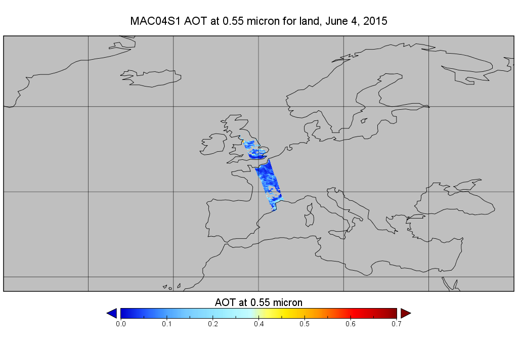
MODIS/Aqua Aerosol 10km 5-Min L2 Wide Swath Subset along CloudSat V002 (MAC04S1) at GES DISC NGDA
National Aeronautics and Space Administration —
This is the wide-swath MODIS/Aqua subset along CloudSat field of view track. The goal of the wide-swath subset is to select and return MODIS data that are within...

Official websites use .gov
A
.gov website belongs to an official government
organization in the United States.
Secure .gov websites use HTTPS
A
lock (
) or https:// means you’ve safely connected to
the .gov website. Share sensitive information only on official,
secure websites.