
-
Federal
China Dimensions Data Collection: China Maps Bibliographic Database
National Aeronautics and Space Administration —
The China Maps Bibliographic Database is an historical collection of bibliographic information for more than 400 maps of China. The information resides in a... -
Federal
Lunar Orbiter Photo Gallery
National Aeronautics and Space Administration —
The Lunar Orbiter Photo Gallery is an extensive collection of over 2,600 high- and moderate-resolution photographs produced by all five of the Lunar Orbiter missions.... -
Federal
GPM IMERG Final Precipitation L3 1 month 0.1 degree x 0.1 degree V07 (GPM_3IMERGM) at GES DISC
National Aeronautics and Space Administration —
Version 07B is the current version of the IMERG data sets. Older versions will no longer be available and have been superseded by Version 07. The Integrated Multi-... -
Federal
Precipitation Measurement Missions Data Access
National Aeronautics and Space Administration —
Tropical Rainfall Measuring Mission (TRMM) data products are currently available from 1998 to the present. Global Precipitation Measurement (GPM) mission data... -
Federal
Aqua MODIS Global Mapped Chlorophyll (CHL) - NRT Data, version R2022.0 NGDA
National Aeronautics and Space Administration —
The Ocean Biology DAAC produces near real-time (quicklook) products using the best-available combination of ancillary data from meteorological and ozone data. As... -
Federal
Potential Impacts of Climate Change on World Food Supply: Datasets from a Major Crop Modeling Study
National Aeronautics and Space Administration —
The Potential Impacts of Climate Change on World Food Supply: Datasets from a Major Crop Modeling Study contain projected country and regional changes in grain crop... -
Federal
Archive of Chandra Cluster Entropy Profile Tables (ACCEPT) Catalog
National Aeronautics and Space Administration —
This table, the Archive of Chandra Cluster Entropy Profile Tables (ACCEPT) Catalog, contains the radial entropy profiles of the intracluster medium (ICM) for a... -
Federal
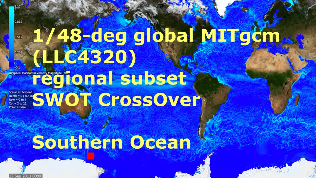
Southern Ocean Pre-SWOT Level-4 Hourly MITgcm LLC4320 Native Grid 2km Oceanographic Dataset Version 1.0
National Aeronautics and Space Administration —
This dataset provides a regional multivariate oceanographic state estimate from a global ocean numerical simulation with a focus on the Southern Ocean region. The... -
Federal
Global Navigation Satellite System (GNSS) IGS Summary of Orbit and Clock Comparisons of Analysis Center (AC) and Combination Real-Time Solutions with IGS Rapid Solutions from NASA CDDIS
National Aeronautics and Space Administration —
This derived product set consists of a summary comparing the International GNSS Service (IGS) Real-Time Service (RTS) orbit and clock products from all analysis... -
Federal
Submarine Upward Looking Sonar Ice Draft Profile Data and Statistics, Version 1
National Aeronautics and Space Administration —
This data set consists of upward looking sonar sea ice draft data collected by submarines in the Arctic Ocean. It includes data from both U.S. Navy and Royal Navy... -
Federal
The NASA Air Traffic Management Ontology (atmonto)
National Aeronautics and Space Administration —
The NASA ATM (Air Traffic Management) Ontology describes classes, properties, and relationships relevant to the domain of air traffic management, and represents... -
Federal
Catalog of AGN in the XMM-Newton Archive
National Aeronautics and Space Administration —
This table comprises CAIXA, the "Catalog of AGN In the XMM-Newton Archive". It consists of all the radio-quiet, X-ray unobscured (NH < 2 x 1022 cm-2) active... -
Federal
BOREAS RSS-08 BIOME-BGC SSA Simulations of Annual Water and Carbon Fluxes
National Aeronautics and Space Administration —
The BOREAS RSS-08 team performed research to evaluate the effect of seasonal weather and landcover heterogeneity on boreal forest regional water and carbon fluxes... -
Federal
HAQAST Sentinel-5P TROPOMI Nitrogen Dioxide (NO2) GLOBAL Annual Level 3 0.1 x 0.1 Degree Gridded Data Version 2.4 (HAQ_TROPOMI_NO2_GLOBAL_A_L3) at GES DISC
National Aeronautics and Space Administration —
This product provides level 3 annual averages of tropospheric Nitrogen dioxide (NO2) vertical column density derived from the level 2 Tropospheric Monitoring... -
Federal
IceCube All-Sky Point-Source Neutrino Events Catalog (2008-2018)
National Aeronautics and Space Administration —
IceCube has performed several searches for point-like sources of neutrinos. The events contained in this release make up the sample used in IceCube's 10-year time-... -
Federal
VIIRS/NPP Burned Area Monthly L4 Global 500m SIN Grid V002
National Aeronautics and Space Administration —
The daily NASA/NOAA Suomi National Polar-orbiting Partnership (Suomi NPP) Visible Infrared Imaging Radiometer Suite (VIIRS) Burned Area (VNP64A1) Version 2 data... -
Federal
RASS/All-Sky Automated Survey Eclipsing Binaries Catalog
National Aeronautics and Space Administration —
The authors have combined their catalog of eclipsing binaries from the All-Sky Automated Survey (ASAS) with the ROSAT All-Sky Survey (RASS) Bright and Faint Source... -
Federal
First ISCCP Regional Experiment (FIRE) Atlantic Stratocumulus Transition Experiment (ASTEX) INMG Funchal Sounding Data
National Aeronautics and Space Administration —
The First ISCCP Regional Experiments have been designed to improve data products and cloud/radiation parameterizations used in general circulation models (GCMs).... -
Federal
NLDAS Noah Land Surface Model L4 Monthly 0.125 x 0.125 degree V2.0 (NLDAS_NOAH0125_M) at GES DISC
National Aeronautics and Space Administration —
This data set contains fifty-two fields simulated from the Noah land-surface model (LSM) for Phase 2 of the North American Land Data Assimilation System (NLDAS-2)....

Official websites use .gov
A
.gov website belongs to an official government
organization in the United States.
Secure .gov websites use HTTPS
A
lock (
) or https:// means you’ve safely connected to
the .gov website. Share sensitive information only on official,
secure websites.