
-
Federal
MISR Level 2 Aerosol parameters V003
National Aeronautics and Space Administration —
MIL2ASAE_3 is the Multi-angle Imaging SpectroRadiometer (MISR) Level 2 Aerosol parameters Version 3 product. It contains information on retrieved aerosol column... -
Federal
Revised Luyten Half-Second (LHS) Catalog
National Aeronautics and Space Administration —
The Revised Luyten Half-Second (LHS) Catalog contains refined coordinates and proper motion data for the high proper motion (HPM) stars listed in the Original Luyten... -
Federal
Second INTEGRAL AGN Catalog
National Aeronautics and Space Administration —
The INTEGRAL mission provides a large data set for studying the hard X-ray properties of AGN and allows testing the unified scheme for AGN. This table contains some... -
Federal
Canadian Meteorological Centre (CMC) Daily Snow Depth Analysis Data, Version 1
National Aeronautics and Space Administration —
This data set consists of a Northern Hemisphere subset of the Canadian Meteorological Centre (CMC) operational global daily snow depth analysis. Data include daily... -
Federal
NASA/IPAC Infrared Science Archive
National Aeronautics and Space Administration —
IRSA is chartered to curate the calibrated science products from NASAs infrared and sub-millimeter missions, including five major large-area/all-sky surveys. IRSA... -
Federal
GPM Ground Validation NOAA X-band Polarimetric Radar (NOXP) IPHEx
National Aeronautics and Space Administration —
The GPM Ground Validation NOAA X-band dual-Polarimetric radar (NOXP) IPHEx dataset consists of differential reflectivity, differential phase shift, co-polar cross... -
Federal
Annual Mean PM2.5 Components Trace Elements (TEs) 50m Urban and 1km Non-Urban Area Grids for Contiguous U.S., 2000-2019, v1
National Aeronautics and Space Administration —
The Annual Mean PM2.5 Components Trace Elements (TEs) 50m Urban and 1km Non-Urban Area Grids for Contiguous U.S., 2000-2019, v1 data set contains annual predictions... -
Federal
GPM GROUND VALIDATION DUAL-FREQUENCY DUAL-POLARIZED DOPPLER RADAR (D3R) IPHEX
National Aeronautics and Space Administration —
The GPM Ground Validation Dual-frequency Dual-polarized Doppler Radar (D3R) IPHEx data set contains radar reflectivity and doppler velocity measurements. The D3R was... -
Federal
Global Navigation Satellite System (GNSS) IGS Ultra-Rapid Orbit Solution Comparison Summary Product from NASA CDDIS
National Aeronautics and Space Administration —
This derived product set consists of Global Navigation Satellite System Rapid Orbit/Reference Frame Product Summary from the NASA Crustal Dynamics Data Information... -
Federal
PSP FIELDS Digital Fields Board (DFB) AC-coupled Differential Voltage, V3-V4 Antennae, Dipole Mode, Spectra, High Gain, Sensor coordinates, Level 2 (L2), 0.873813 s Data
National Aeronautics and Space Administration —
PSP FIELDS Digital Fields Board, DFB, dV34hg data:\n\nThe DFB is the low frequency, less than 75 kHz, component of the FIELDS experiment on the Parker Solar Probe... -
Federal
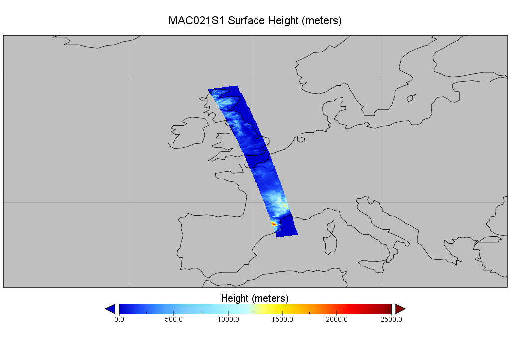
MODIS/Aqua Calibrated Radiances 250m 5-Min L1B Wide Swath Subset along CloudSat V002 (MAC02QS1) at GES DISC
National Aeronautics and Space Administration —
This is the wide-swath MODIS/Aqua subset along CloudSat field of view track. The goal of the wide-swath subset is to select and return MODIS data that are within... -
Federal
MERRA-2 tavgU_2d_lnd_Nx: 2d,diurnal,Time-Averaged,Single-Level,Assimilation,Land Surface Diagnostics 0.625 x 0.5 degree V5.12.4 (M2TUNXLND) at GES DISC
National Aeronautics and Space Administration —
M2TUNXLND (or tavgU_2d_lnd_Nx) is a time-averaged 2-dimensional monthly diurnal means data collection in Modern-Era Retrospective analysis for Research and... -
Federal
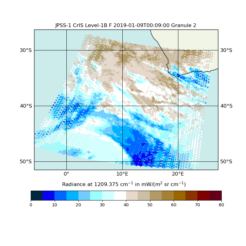
JPSS-1 CrIS Level 1B Full Spectral Resolution V2 (SNDRJ1CrISL1B) at GES DISC
National Aeronautics and Space Administration —
The Cross-track Infrared Sounder (CrIS) Level 1B Full Spectral Resolution (FSR) data files contain radiance measurements along with ancillary spacecraft, instrument,... -
Federal
Global Land Survey 1990
National Aeronautics and Space Administration —
Global Land Survey 1990 images were acquired from 1987 to 1997 by Landsat 4-5 TM. The U.S. Geological Survey (USGS) and the National Aeronautics and Space... -
Federal
Astrographic Catalog of Reference Stars
National Aeronautics and Space Administration —
For a number of years there has been a great demand for a high-density catalog of accurate stellar positions and proper motions that maintains a consistent system of... -
Federal
SWOT Level 2 Nadir Altimeter Operational Geophysical Data Record with Waveforms, Version 2.0
National Aeronautics and Space Administration —
The SWOT Level 2 Nadir Altimeter Operational Geophysical Data Record (OGDR) with Waveforms Version 1.0 dataset produced by the Surface Water and Ocean Topography... -
Federal
Global Vegetation Height Metrics from GEDI and ICESat2
National Aeronautics and Space Administration —
This dataset provides global rasters of relative height metrics for vegetation from Global Ecosystem Dynamics Investigation (GEDI) L2A data and Ice, Cloud, and Land... -
Federal
Land Resources of Russia -- Maps of Soil Characteristics, Version 1
National Aeronautics and Space Administration —
This data set consists of maps of various soil characteristics for all of Russia. The maps are available as ESRI Shapefiles and they are accompanied by databases of... -
Federal
Sentinel-1 Single Look Complex (SLC) Bursts
National Aeronautics and Space Administration —
Sentinel-1 Interferometric Wide (IW) and Extra Wide (EW) swath modes are collected using a form of ScanSAR imaging called Terrain Observation with Progressive Scans... -
Federal
IceBridge Sea Ice Freeboard, Snow Depth, and Thickness Quick Look, Version 1
National Aeronautics and Space Administration —
This data set is an evaluation product containing derived geophysical data products retrieved over the Arctic sea ice cover, using the IceBridge Airborne Topographic...

Official websites use .gov
A
.gov website belongs to an official government
organization in the United States.
Secure .gov websites use HTTPS
A
lock (
) or https:// means you’ve safely connected to
the .gov website. Share sensitive information only on official,
secure websites.