-
Federal
TES/Aura L2 Methanol Lite Nadir V006
National Aeronautics and Space Administration —
Atmospheric vertical profile estimates and associated errors including the mapping matrix to relate the reduced-size retrieval vectors, covariances, and averaging... -
Federal
AMSR-E/AMSR2 Unified L3 Global 5-Day 25 km EASE-Grid Snow Water Equivalent V001
National Aeronautics and Space Administration —
This AMSR-E/AMSR2 Unified Level-3 (L3) data set provides 5-day maximum estimates of Snow Water Equivalent (SWE). SWE was derived from brightness temperature... -
Federal
AMSR-E/Aqua Monthly L3 5x5 deg Rainfall Accumulations V002
National Aeronautics and Space Administration —
This Level-3 rainfall accumulation product (AE_RnGd) consists of two grids of 28 rows by 72 columns of monthly averaged rainfall accumulation over ocean and land.... -
Federal
SMAPVEX19-22 Millbrook UAVSAR Mosaics V001
National Aeronautics and Space Administration —
This data set consists of mosaicked Uninhabited Aerial Vehicle Synthetic Aperture Radar (UAVSAR) images corrected for terrain-flattened gamma. Data image files at... -
Federal
Nimbus-7 Narrow Field of View (NFOV) Maximum Likelihood Cloud Estimation (MLCE) Data in Native Format
National Aeronautics and Space Administration —
NIMBUS7_NFOV_MLCE data are Nimbus 7 Narrow Field of View (NFOV) Maximum Likelihood Cloud Estimation (MLCE) Data in Native Format.The NIMBUS7_NFOV_MLCE data set uses... -
Federal
VIIRS/JPSS1 Ice Surface Temperature Daily L3 Global 750m EASE-Grid 2.0 Night V002
National Aeronautics and Space Administration —
This data set reports sea ice surface temperature (IST) derived from radiance data acquired by the Visible Infrared Imager Radiometer Suite (VIIRS). Following the... -
Federal
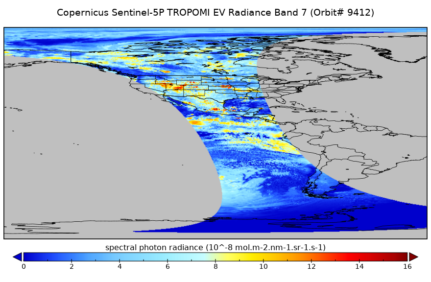
Sentinel-5P TROPOMI Radiance product band 7 (SWIR detector) L1B 5.5km x 7km V2 (S5P_L1B_RA_BD7_HiR) at GES DISC
National Aeronautics and Space Administration —
Starting from August 6th in 2019, Sentinel-5P TROPOMI along-track high spatial resolution (~5.5km at nadir) has been implemented. For data before August 6th of 2019,... -
Federal
SMAP_L1A_RADAR_RECEIVE_ONLY_QA_V001
National Aeronautics and Space Administration —
SMAP Level 1A Radar Receive Only Data Quality Information Version 1 -
Federal
Sentinel-5P TROPOMI Aerosol Layer Height 1-Orbit L2 7km x 3.5km V1 (S5P_L2__AER_LH) at GES DISC
National Aeronautics and Space Administration —
Starting from August 6th in 2019, Sentinel-5P TROPOMI along-track high spatial resolution (~5.5km at nadir) has been implemented. For data after August 6th of 2019,... -
Federal
Turbulent Air Motion Measurement System (TAMMS) IMPACTS V1
National Aeronautics and Space Administration —
The Turbulent Air Motion Measurement System (TAMMS) IMPACTS dataset consists of wind speed, wind direction, and cross wind speed measurements from the TAMMS... -
Federal
ABoVE LVIS L2 Geolocated Surface Elevation Product V001
National Aeronautics and Space Administration —
This data set contains surface elevation data over Alaska and Western Canada measured by the NASA Land, Vegetation, and Ice Sensor (LVIS), an airborne lidar scanning... -
Federal
AIRSAR_TOPSAR_DEM_C
National Aeronautics and Space Administration —
AIRSAR topographic SAR digital elevation model CTIF product -
Federal
SWOT Level 2 Lake Single-Pass Vector Data Product, Version 2.0
National Aeronautics and Space Administration —
The SWOT Level 2 Lake Single-Pass Vector Data Product from the Surface Water Ocean Topography (SWOT) mission provides water surface elevation, area, storage change... -
Federal
SWOT Level 2 Radiometer Brightness Temperatures and Troposphere Operational Data Product, Version 2.0
National Aeronautics and Space Administration —
The SWOT Level 2 Radiometer Brightness Temperatures and Troposphere Operational Geophysical Data Record (OGDR) Version 1.0 dataset produced by the Surface Water and... -
Federal
NOAA-21 VIIRS Regional Ocean Color (OC) - Near Real Time (NRT) Data, version R2022.0
National Aeronautics and Space Administration —
The Ocean Biology DAAC produces near real-time (quicklook) products using the best-available combination of ancillary data from meteorological and ozone data. As... -
Federal
Gridded Population of the World, Version 4 (GPWv4): Administrative Unit Center Points with Population Estimates, Revision 11
National Aeronautics and Space Administration —
The Gridded Population of the World, Version 4 (GPWv4): Administrative Unit Center Points with Population Estimates, Revision 11 consists of UN WPP-adjusted... -
Federal
SnowEx20 Cameron Pass Ground Penetrating Radar Raw V001
National Aeronautics and Space Administration —
This data set contains the raw files from ground-penetrating radar surveys conducted at Cameron Pass, Colorado during the SnowEx20 campaign. Data were collected... -
Federal
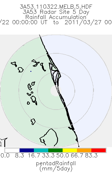
TRMM Ground Validation Radar Site Rain Totals Map L3 5 days 2 km V7 (TRMM_3A53) at GES DISC
National Aeronautics and Space Administration —
This is the 5-day accumulation of the 2A53 product, 'Radar Site Rain Map', which originally is an instantaneous surface rain rate map in Cartesian coordinates with a... -
Federal
ACES Aircraft and Mechanical Data V1
National Aeronautics and Space Administration —
The ACES Aircraft and Mechanical Data consist of aircraft (e.g. pitch, roll, yaw) and mechanical (e.g. aircraft engine speed, tail commands, fuel levels) data... -
Federal
USGS Global Forest Observations Initiative (GFOI) Colombia
National Aeronautics and Space Administration —
The Global Forest Observations Initiative (GFOI) is an initiative of the inter-governmental Group on Earth Observations (GEO) that aims to: foster the sustained...

Official websites use .gov
A
.gov website belongs to an official government
organization in the United States.
Secure .gov websites use HTTPS
A
lock (
) or https:// means you’ve safely connected to
the .gov website. Share sensitive information only on official,
secure websites.